
Queensland weather forecast: Frost, storms to hit state’s southeast
One state has been warned to rug up ahead of frost, thunderstorms and zero degree temperatures this weekend as an icy snap hits.
Queenslanders are preparing to reach for a jumper – or maybe even a sneaky pair of Ugg boots – with frost, thunderstorms and zero degree temperatures forecast this weekend as a cold snap hits the state’s southeast.
The mercury in the Darling Downs could drop to 0C, while Brisbane will shiver through lows of 9C as a cold front makes its way across Australia’s southeast today toward the sunshine state.
Dubbed an “icy blanket”, the plunge in temperatures is due to a complex low pressure system currently sitting deep in the Southern Ocean, Sky Weather meteorologist Alison Osborne explained.
“It’s expected to bring widespread rain first, set to hit parts of southern and Central Australia, followed by a significant wintry blast to end the week,” she said.
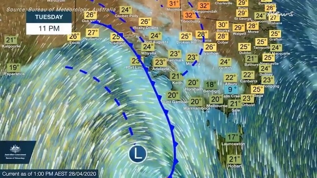
A southern cold snap is heading for #Queensland late this week with cooler temps for most of the State, rainfall in the south and raised dust in the west. Single digit minimums & frost forecast for some areas. Stay up to date w/ #QldWeather forecasts: https://t.co/b4Mpsop7GR ðŸŒ¡ï¸ pic.twitter.com/huLoEWJKjK
— Bureau of Meteorology, Queensland (@BOM_Qld) April 27, 2020
Bureau of Meteorology forecaster Peter Markworth said Queensland’s southeast will experience minimum temperatures on Saturday 6-10 degrees below average for this time of year.
“Saturday is likely to be the coldest day,” Mr Markworth told The Courier-Mail.
“Most of southwest Queensland will see minimums into the single digits, Stanthorpe and Warwick for example potentially could minimums around 0 degrees.”
The state’s southern interior can expect frost from Friday onwards, when temperatures dip lower than 5C.
Weatherzone meteorologist Joel Pippard said mornings in the southeast will be “very chilly” and winds will make weather during the day feel up to 3C colder than it is.
“We’re going to see cooler temperatures that we haven’t really seen so far this year and the winds are going to be the biggest thing that’s going to make people think that it’s colder,” Mr Pippard said.
The change will move through South Australia overnight, with a chance of intermittent heavy falls in New South Wales and Victoria as that rain band spills east.
From Thursday into Friday, Ms Osborne said, a low pressure system will deepen to the south of Tasmania, delivering another burst of icy winds.
Not even the Northern Territory will miss out on the cold outbreak, with the air mass pushing as far north as Alice Springs.
Places like the Red Centre, as well as Birdsville, can expect a swing in maximum temperatures of between 10C and 15C.
Across the south, Adelaide, Melbourne and Hobart are expected to see their mercury absolutely plunge, Ms Osborne said.
Temperatures in Hobart will dip to 7C on Saturday, with showers forecast through the end of the week.
Melbourne’s also set for a rainy weekend, with highs of between 13C and 15C and lows of 8C on Friday.
Meanwhile Canberra can expect single digit maximums, with highs of 7C and 9C on Friday and Saturday, and the mercury dipping as low as 1C on both days of the weekend.
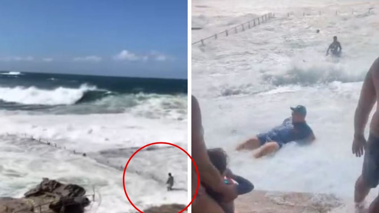
Aussie ‘idiots’ take on deadly waves
Videos uploaded to social media show people clearing not heeding warnings from surf lifesavers as massive swells claim lives across the country .

Search as city smashed by monster waves
An urgent search is underway after reports of a person missing in waters off a popular beach, as crowds gather to watch a monster swell smashing the city.
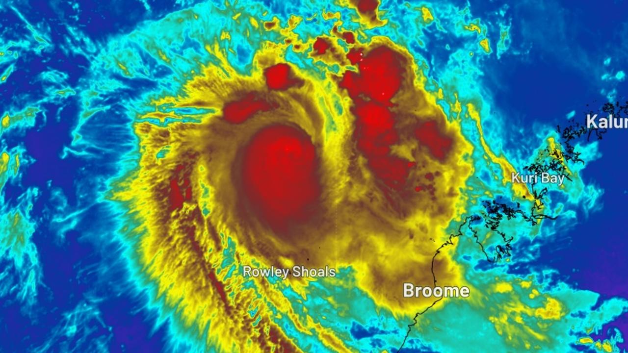
Locals on alert as cyclone nears
Residents are on alert with Cyclone Errol expected to cross the Australian coastline on Friday afternoon, bringing wind gusts of up to 140km.