
NSW weather: Prime Minister to declare national emergency, as 40,000 evacuated in Sydney
Amid ongoing criticism that the government has been too slow to act, Scott Morrison is set to declare a national emergency in relation to the NSW floods.
Prime Minister Scott Morrison will officially declare a national emergency in relation to the floods today during a visit to Lismore amid ongoing criticism that the SES has been too slow to ask for help from Defence.
The declaration is designed to streamline the deployment of Australian Defence Force support and other resources to communities battling rising flood waters and the clean up.
Questions have been raised in recent days over why NSW has not yet declared a state of emergency.
Under the new legislation which was passed after the black summer bushfires, the states recommend the declaration of a national emergency to the Prime Minister and the Commonwealth.
But that hasn’t occurred in this instance. The Prime Minister has the power to declare a national emergency without a request from NSW and that is what has occurred in this instance.
The declaration of a national emergency is largely administrative, it allows the Commonwealth to move faster on deployments and logistical matters with less red tape.
Underlining that red tape, the head of ADF Recovery Mission in Lismore, Brigadier Robert Lording revealed this morning they were still waiting to be asked to help people in Sydney after flooding overnight.
There are around 250 ADF troops on standby and ready to help.
“I know it’s been pretty severe. We haven’t received a direct request from NSW SES to step those people out the door yet but they are ready to go when we get that call,’’ he told 2GB radio.
“We’ve had a request to have them on standby. They are there ready to go out the door.
“SES have the lead. They come to us and ask for an assistance process and we ready those troops.”

NSW Premier Dom Perrottet has described the NSW floods as an “unpredictable freak catastrophe.”
He conceded that the emergency response to the NSW floods was not adequate and will hold an investigation into what occurred.
“Had neighbours not got in boats then I believe the death toll would have been much higher,” the Premier told ABC radio.
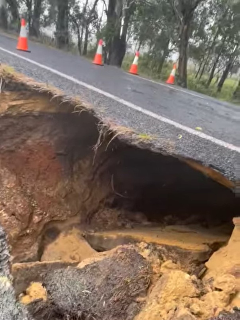
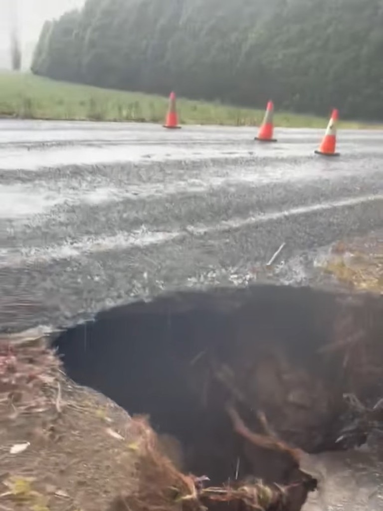
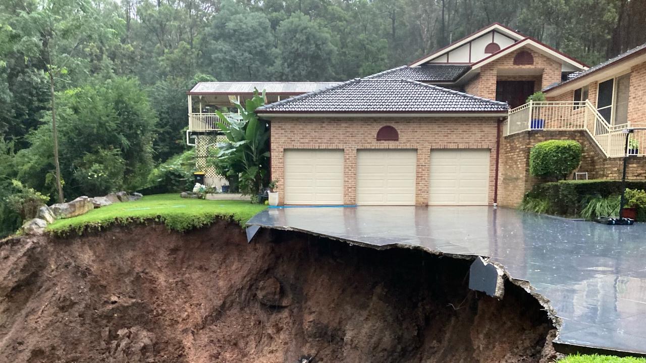
Massive sinkhole on Sydney highway
A massive sinkhole on the Illawarra Highway has opened up near the Southern Highlands village of Burrawang.
The Hume Police District shared a video of the large cavity, which shows the sinkhole extending underneath one side of the bitumen road to the other. As it stands, the road on top of the sinkhole has not collapsed.
Currently, the Illawarra Highway between Robertson and Moss Vale has been closed as a result. Diversions are also in place for light vehicles, however heavy vehicles have been declared unsuitable for the road.
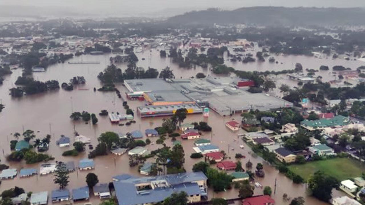
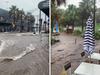
More than 40,000 ordered to evacuate
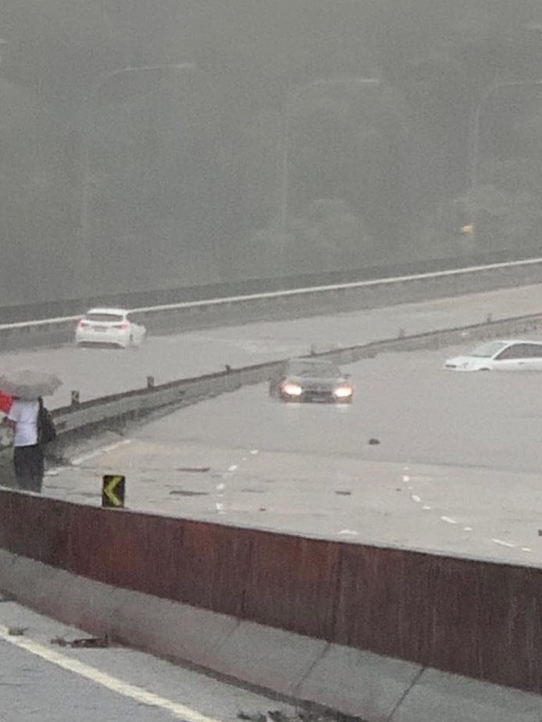
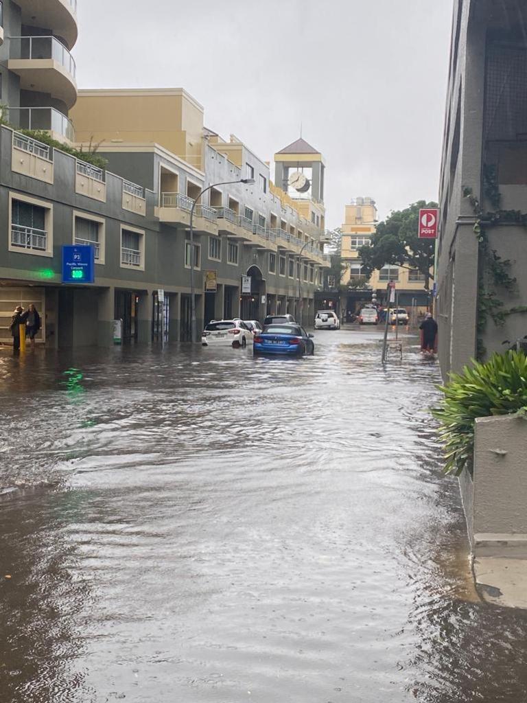
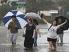
More than 40,000 people have been ordered to evacuate their homes across NSW and a further 18,000 are on alert as the state braces for another day of devastation.
Overnight, land slippages threatened homes, hundreds of cars became trapped on flooded roads and evacuation orders were issued as floodwaters continued to rise across Sydney’s northern and western suburbs, the Hunter Valley and Kempsey.
Flood levels in parts of the NSW capital are expected to reach new highs not seen since March 1978, with more than 65 evacuation orders now in place.
Evacuation centres were established to help those with nowhere else to go, including at Mona Vale and Freshwater Surf Club on the Northern Beaches, and Penrith RSL in Sydney’s west.
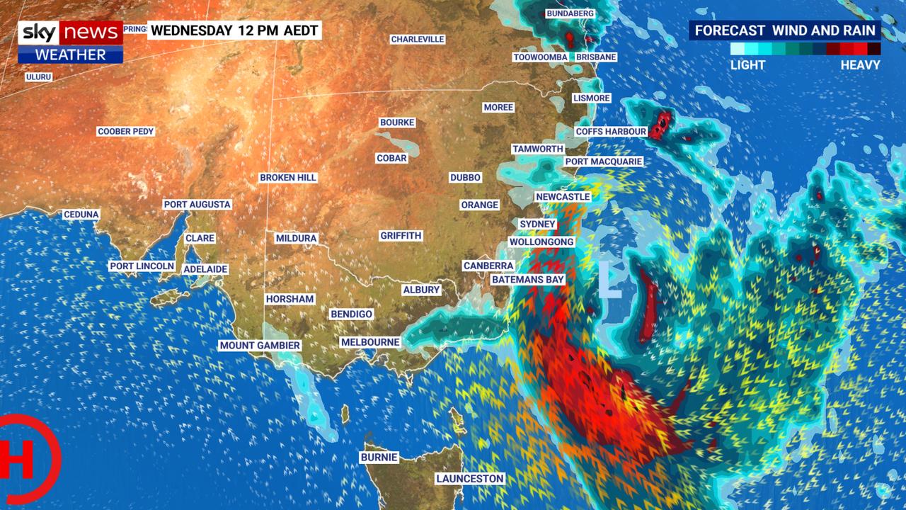
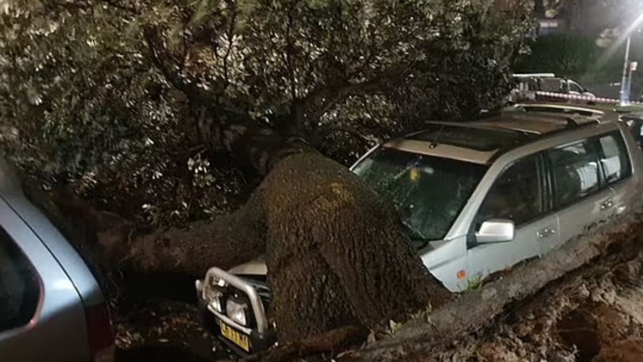
After intense rainfall led to flash flooding across Sydney’s northern beaches yesterday, the Bureau now warns damaging winds could lash a 600km stretch of the NSW coastline.
A severe weather warning was updated on Wednesday morning, with winds of up to 90km/hr expected from the Mid North Coast down to the South Coast.
âš ï¸ Severe Weather Warnings for DAMAGING WIND gusts and DAMAGING Surf have been reissued. While some showers will persist, HEAVY RAINFALL is no longer expected as has been removed from the warning. DANGEROUS FLOODING will continue for coming days. Detials: https://t.co/Ss766eSCrLpic.twitter.com/SMdr4lfxrO
— Bureau of Meteorology, New South Wales (@BOM_NSW) March 8, 2022
Strong winds continue along much of the NSW coast today, bringing risk of falling trees and powerlines. Crews have been kept busy overnight clearing debris with 100kph+ winds recorded. Severe weather warning remains in place. 📷 Loftus Brigade #nswrfspic.twitter.com/snEvb3daqy
— NSW RFS (@NSWRFS) March 8, 2022
Molineux Point recorded a 111km/hr guest late last night, while Sydney Airport also saw an intense 94km/hr wind gust at 9.20pm.
“The State Emergency Service advises that people should move vehicles under cover or away from trees, secure or put away loose items around your house, yard and balcony and keep at least eight metres away from fallen power lines or objects that may be energised, such as fences,” the Bureau warned in a statement.
SES spokeswoman Andrea Cantle said she was concerned that the strong winds that developed overnight could further complicate Sydney’s weather event, with trees potentially falling due to overly saturated soil.
Ms Cantle urged the community to be “as careful as possible”, adding that the SES are “asking people to avoid the road”.
“With properties, put away any loose items, bring your pets indoors because it’s going to get quite windy, the rain may die down and the wind will pick up,” she said.
A separate severe weather warning for hazardous surf has been issued across the Hunter Coast, Sydney Coast, Illawarra Coast, Batemans Coast and Eden Coast.
The “adverse weather conditions” have again forced the closure of a large number of schools across the NSW.
Further north, the SES directed residents along the Hunter River within Glenridding Dunolly and Combo to evacuate “high danger areas”.
The rising Hawkesbury – predicted to peak at Windsor at noon on Wednesday – also threatened homes at McGraths Hill and Mulgrave, with the SES saying, “once floodwater reaches 13.5 metres at Windsor, the area will be isolated”.
While reprieve from the rain is forecast for Thursday, Bureau of Meteorology senior meteorologist Dean Narramore warned that more rainfall in already soaked catchments is likely – and dangerous.
“Even though the sun does come out, we are likely to see many of these rivers continuing to experience major flooding,” Mr Narramore said.
“And for some, the flood peak won’t occur until Wednesday or Thursday.”
The Hawkesbury and Nepean Rivers remain of most concern, with Mr Narramore saying both were in danger of experiencing flooding levels “equal to or greater than what we saw in March of 2021”.
Western Sydney residents out of homes for another week
It’s unlikely that some residents in Sydney’s west forced to flee their homes last week will be able to return for at least another seven days, the SES has said.
NSW SES spokesman Phil Campbell said that water levels at the Hawkesbury River had topped last year’s flood event in many locations, adding that flood warnings would remain in place for the likes of North Richmond and Windsor for some time.
“In western Sydney we’re looking at flooding levels higher than last year, meaning that people that have been evacuated near McGraths Hill and Windsor, who sadly have been evacuated out there for close to a week, it looks like it’ll be close to a week before they can go back,” he said.
“These floods waters go up very quickly and take so long to drain out – it’s described as a bathtub effect.
“We’re going to continue to see high water levels and it won’t be until later today that the Hawkesbury will peak. It’s already peaked in North Richmond but it’ll likely peak around noon today in Windsor.
“We’re looking at rivers that go up really fast but slowly creep up and down again.”
Warning of ‘extreme’ public transport delays
Transport for NSW has again advised people to avoid the rail network, after yesterday’s conditions wrought havoc on the system with flooding, landslips and fallen trees on tracks.
“Severe weather conditions are currently affecting the network with significant disruptions and larger than normal service gaps,” the department said in a statement.
“Please avoid any non-essential travel, and if you have to travel please plan ahead and leave plenty of extra travel time.”
Speaking to 2GB radio on Wednesday morning, NSW Transport Minister David Elliott urged all commuters to “rethink” whether they needed to travel and warned of “extreme” delays.
“There will be further delays today. We’ve got forecasts of 100km/h of winds expected,” Mr Elliott said.
“A lot of the system is going to be affected today. My message to listeners is given these delays you might get more productivity working from home.”

Nightmare pic shows your weekend is cooked
A low-pressure system is rapidly building offshore, with Aussies in several states warned they will cop the brunt of the wild weather.

‘Most massive evacuation ever’ after quake
About 1.4 million people have been ordered to move to higher ground in what one country called “the most massive evacuation ever carried out”.

Worst yet to come as millions drenched
One Aussie state is expected to receive up to 150mm of rain within days, as its capital city sets a bleak winter record.