
Negative Indian Ocean Dipole climate driver to bring more rain to Australia until December
With La Nina only recently declared over, another key weather driver has hinted that Australia’s spate of rain could stretch into yet another summer.

As flood-torn areas in NSW and Queensland continue to recover from unprecedented levels of rain, it appears the wet weather is likely to continue.
Sky News’ Chief Meteorologist Thomas Saunders has forecast above average rainfalls will likely last until November or December, predicting a negative Indian Ocean Dipole (IOD) year for 2022.
Describing it as the “Indian Ocean version of La Nina,” the Indian Ocean Dipole is one of the main climate drivers which affects Australia. While the El Nino – Southern Oscillation (ENSO) system (which determines a El Nino/ La Nina climate pattern) refers to the winds and sea surface temperatures of the Pacific Ocean to Australia’s east, the IOD refers to the Indian Ocean, which borders Australia’s west.
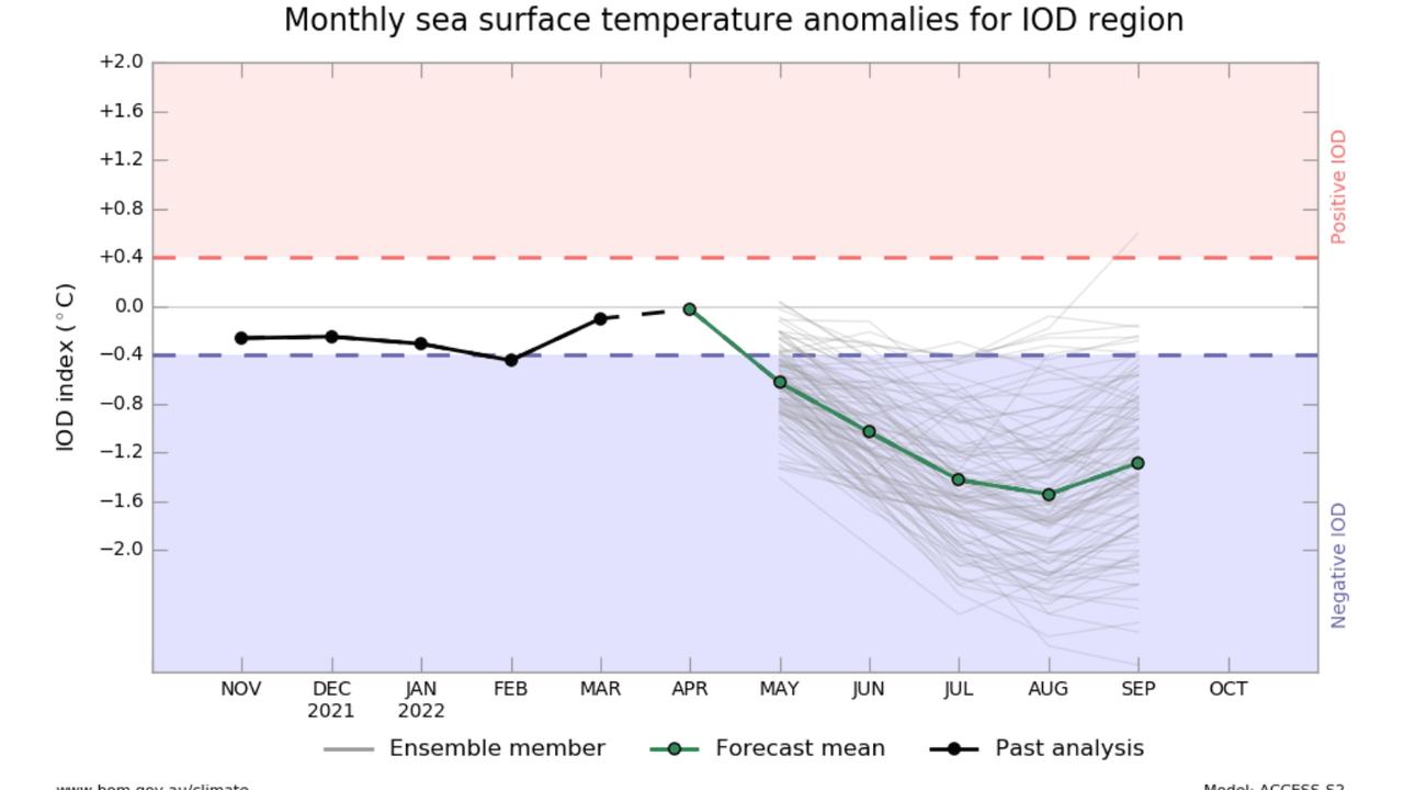
Latest Indian Ocean Dipole value is the lowest since Sep 2016. We can probably call it now, 2022 will be a -IOD year. The value needs to remain below -0.4 for 8 weeks to make it official. Why does this matter? The rain is here to stay. @SkyWeatherAUS@SkyNewsAustpic.twitter.com/OHZkOkJkZW
— Thomas Saunders (@TomSaundersSNW) July 11, 2022
Although positive IOD years result in dryer and less cloudy winter and spring periods with less rainfall over southern Australia and the Top End, negative IOD years have the opposite effect.
Instead, the weather event will bring increased chances for “above average winter – spring rainfall,” as well as “warmer days and nights for Northern Australia,” the Bureau of Meteorology (BOM) states.
2021 was a negative IOD year, as was 2016.
“Latest Indian Ocean Dipole value is the lowest since September 2016. We can probably call it now, 2022 will be a -IOD year,” Mr Saunders said on Monday afternoon.
“The value needs to remain below -0.4 for 8 weeks to make it official. Why does this matter? The rain is here to stay.”
The most recent update from the BOM also indicates a negative Indian Ocean Dipole is likely.
This comes as capital cities on Australia’s east coast have already surpassed their average yearly rainfall totals this year. With an average of 1214mm of rain each year, Sydney has already recorded a total of 1859mm. Brisbane has also surpassed its 1130mm average total, with 1627mm recorded this year.
Will La Nina happen again in 2022?
Although La Nina has officially ended for 2022, the BOM has warned that while rare, a third year of the wet weather system could be possible.
“Back to back La Ninas are not uncommon,” said the Bureau of Meteorology’s head of long-range forecasting, Dr Andrew Watkins.
“In fact we get them about half the time since 1900.
“But a three-year La Nina is less common and we’ve only seen that three times since the middle of the last century.”
Currently, the BOM have put out a ‘watch’ update for the return of La Nina, meaning there is around a 50 per cent chance of the weather even resurging. Notably, this is “approximately double the normal likelihood” we would be seeing during this time of the year.
The US National Weather Service’s prediction is slightly more in favour for a third year of La Nina. The most recent reports indicate there is also a 58 to 59 per cent chance of La Nina to increase in the spring/ summer period of 2022.

Brutal winter blast sparks warnings
A savage winter blast is sweeping across the country, bringing gale-force winds, icy temperatures and widespread weather alerts.

States told to brace for weekend cold front
Windy weather has finally subsided across Australia’s southern regions, but a cold front is bearing down on these states for the weekend.

Fury as fire ants hit major coalmine
A fire ant outbreak has hit a coalmine in a major mining state, with environmentalists calling the discovery a “spectacular failure”.