
Worst of El Nino yet to come with severe bushfires predicted across Australia over summer
ONE capital city is likely to be spared the brunt of the “Godzilla El Niño”. The rest ... aren’t quite so lucky. Here’s what you should know.
LIKE a superhero in a cape, the Indian Ocean has come to the rescue of southern and central Australia, saving it from the worst of the “Godzilla” El Niño.
The massive weather event — which is expected to cause an outbreak of potentially unstoppable bushfires in coming months — will wreak havoc throughout the country.
However, the Indian Ocean has managed to shield one of our biggest cities — Melbourne — from the disastrous effects.
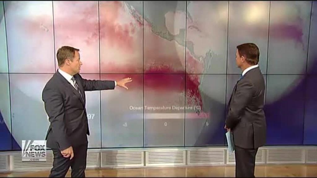
Bureau of Meteorology climate monitoring and prediction manager David Jones said the ocean, which is now the warmest it has been in a century, had fended off the wrath of the Godzilla El Niño in the southern parts of the nation.
“That warmth is protecting [southern regions] because it’s putting moisture into the atmosphere and increasing evaporation, stopping the El Niño from drying out the vulnerable state,” Mr Jones said.
“[Not] everywhere is faring well in the south but, over a fairly large area, it’s generally fared not too badly considering the bad El Niño event,” he said.
El Niños typically reduce rainfall and causes droughts, increased temperatures and bushfires.
The most severe impacts of the rare weather event — which has been overpowering the Pacific Ocean for about five months — are yet to come.
It is said to be stronger than one that broke records when it hit Australia in 1997, earning its name as the Godzilla of El Niño events.
Mr Jones has warned that the weather event was yet to peak, with the Indian Ocean “not necessarily able” to fend it off long term.
“A warm Indian Ocean doesn’t mean we’ll go unscathed,” Mr Jones said.
“Australia has an increased risk of bushfires, particularly in areas that haven’t had good rainfall.
“Things are slowly drying out and that means once the warm weather hits in summer, the moisture evaporates and we find ourselves with dry grass and forests that can easily catch fire.”
According to the Bushfires and Natural Hazards Cooperative Research Centre, large areas of southern Australia, especially along the east and west coasts extending inland, face above normal fire potential for the 2015-16 fire season.
“The above normal forecast is mostly due to a strengthening El Niño over the Pacific Ocean, currently tracking as one of the strongest on record, but is made more complex this year by the influence of warmer sea temperatures in the Indian Ocean,” the warning read.
The climate pattern has already caused severe droughts across southeast Asia and has been working on making Australia its next victim.
Mr Jones said the tropics, including the Top End of the Northern Territory and far north Queensland, were the areas so far most affected by the El Niño within Australia.
“[This year] is tracking to be the hottest year on record and that’s because of the El Niño,” he said.
“The tropics at the moment are suffering after the El Niño led to an early end to the monsoon and the onset of dry conditions.
“Whereas we’re seeing average conditions and rainfall stretching all the way down to through south and Central Australia.”

‘Nonsense’: Albo slams Greens over salmon
The prime minister has gone after the Greens in Question Time over salmon farming in Tasmania.
Small town rocked by earthquake
A small Aussie town has been rocked by a 4.5 magnitude earthquake, with people living near the epicentre reporting shaking houses and a loud rumble.
Supervolcano shift stirs fears of eruption
Scientists say the enormous Yellowstone supervolcano is stirring in its sleep, with concerns the subterranean monster could blow.