
Storms forecast as cool change set to sweep Adelaide
FIVE cars were involved in a crash after strong winds whipped up a huge dust storm from the recent Pinery bushfires in South Australia.
- MUGGY: Humid weather sending us troppo
- FORECAST: Outlook for rest of the week
- LAST WEEK: Widespread rainfall recorded across South Australia
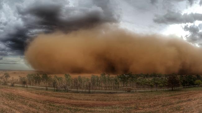
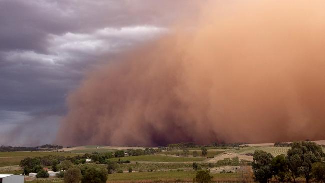
FIVE cars were involved in a crash on the Horrocks Highway, near Tarlee, after strong winds whipped up a massive dust storm from the recent Pinery bushfires, causing visibility problems on our roads.
One person was taken to Gawler Hospital following the accident but there were no serious injuries.
Horrocks Hwy southbound towards Tarlee is closed, with traffic being redirected to Stockport.
Charmaine Holland, who lives at Nain, east of Freeling, said the dust storm was “the most impressive” she had seen.
“We had so many dust storms here in the last few months it’s not funny,” she said.
She said seeing the dust storm approach was “nerve-racking” because her home was ravaged by the Pinery fire last November.
“It was like deja vu,” she said. “Everything was going blood red.”
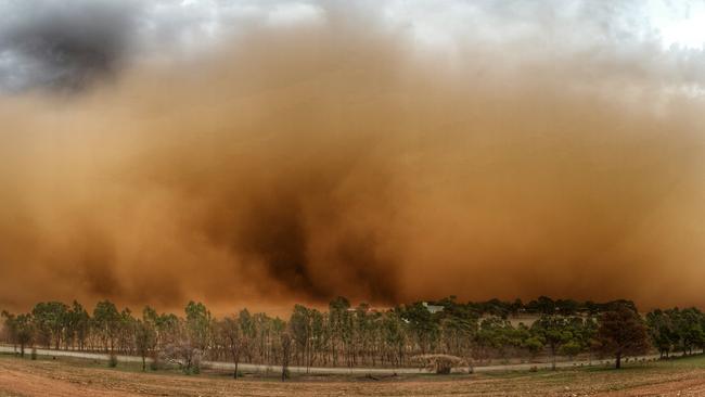
Travis O’Callaghan, of Travis Earth Wines at Barossa Valley, said he spotted the dust storm as he was heading home, about 4.30pm.
“Two minutes after I took that photo, I could barely see 20 metres in front of me,” he said.
“It came through quite quickly but was gone soon.”
Gusts of 93km/h at Roseworthy and 100km/h at Warburton Point were recorded this afternoon.
The bureau earlier issued a severe storm warning for Whyalla, Renmark, Port Augusta, Port Pirie, Clare, Murray Bridge, Naracoorte, Coober Pedy, Roxby Downs, Hawker, Jamestown and Woomera.
Severe thunderstorms with damaging wind gusts of 90 to 120km/h and heavy rainfall may lead to flash flooding in the warning area over the next several hours.
But Mr O’Callaghan said he was not worried about the heavy rains coming into the region.
“It couldn’t hurt seeing that we had a dry winter, spring and summer, more beneficial than damaging really,” he said.
“The temperature has dropped five, six degrees since so that’s helpful.”
Severe thunderstorms were no longer occurring in the West Coast and Yorke Peninsula districts and the warning for these districts was cancelled.
The State Emergency Service (SES) has already responded to 18 jobs, most of them at Whyalla, Wallaroo, Moonta and Kimba, where water has seeped through roofs in homes and businesses.
Severe Thunderstorm Warning issued for damaging winds and heavy rainfall. Keep up to date at https://t.co/5wxFrWeCue pic.twitter.com/SBe0Jsp1CZ
— BOM South Australia (@BOM_SA) March 17, 2016
The humid, summery weather we’ve had so far this March is forecast to be blown away on Thursday evening as a cold front arrives from the west.
Adelaide was forecast to reach 32C today after a warm night where the mercury hovered around 26C. It was hotter than that, with Adelaide reaching 33.2C at 4pm.
The cool change, expected about sunset, will bring a high chance of showers and a possible thunderstorm in Adelaide, the Bureau of Meteorology says.
Rainfall between 3-8mm is expected in Adelaide.
The change will mark the start of much milder conditions over the coming days.
A relatively frosty top of 20C is forecast for Friday, while Saturday is tipped to be 23C and Sunday 26C.
The expected cooler weather is not before time, with many Adelaideans suffering unseasonal hayfever, plagues of ants and other bugs, and frizzy hair.
Originally published as Storms forecast as cool change set to sweep Adelaide


