
Nasty weather change to hit millions as icy polar system moves north
A cold snap bringing record breaking icy temperatures is moving northwards today and is expected smash the east coast with strong winds.

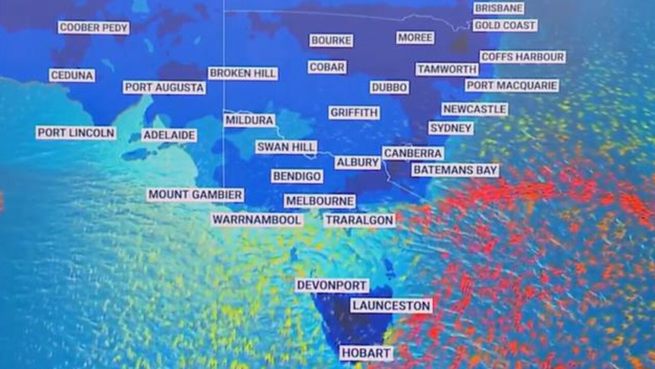
A prolonged cold snap bringing record breaking icy temperatures is moving northwards through Victoria and New South Wales today — smashing the east coast with strong winds, and plunging the mercury as far down as -10C.
It is anticipated that damaging south-westerly gusts of up to 100 kilometres per hour will hit the NSW south coast over the weekend — as forecasters warn the icy blast could drag on until at least Tuesday.
The large polar weather system has already brought temperatures not seen in decades to parts of the nation.
And it’s not just the southern states that are copping it.
Temperatures in Brisbane hit just 6C on Friday — the coldest it has been this time of year since 1904 — while Melbourne is looking at its coldest week this early in the season since 1982 and Sydney since 1989.
Tom Saunders, the Chief Meteorologist for Sky News, said there are more frosty nights ahead for many of us.
He said a “blocking high” sitting south of WA has prevented the normal eastwards progression of weather systems reaching Australia.
Stream more weather news live & on demand with Flash. 25+ news channels in 1 place. New to Flash? Try 1 month free. Offer ends 31 October, 2022 >
“This means very cold polar air just keeps pumping up over southeast Australia, and some of that cold air is pushing all the way up to the tropics,” he said.
Tasmania is copping the worst of the polar system, with snow reaching as far down as sea level south of the state overnight on Saturday and through Sunday, with the possibility of snowfall around parts of Hobart.
“The coldest part of the system starts to move away, but it will still be very cold over southeast Australia,” he said. “There’s another pulse of cold air that will arrive around the middle of next week but this time but this time it’s not as cold as what we’ve seen through this week.”
For those areas not high enough to pick up snow, he said there will be showers and gusty winds for Tasmania, Victoria and southeast NSW on Saturday.
By early next week he said we will see clearer skies and lighter winds, which means colder overnight temperatures for the south and south east of the nation on Sunday and Monday — hitting below 5C in many low-lying areas.

“On Tuesday morning that will be the absolute coldest temperatures, hitting below 5C for much of southern and eastern Australia,” he said, adding there would be “severe frost” on the southern ranges of NSW where the mercury is tipped to plunge to -10C.
La Nina climate cycle could last into 2023
It comes as the current La Niña event which started in September 2020 is expected to now last until at least August, and perhaps continue into 2023.
La Nina refers to the large-scale cooling of surface temperatures in the central and eastern equatorial Pacific Ocean, occurring every two to seven years.
The UN’s World Meteorological Organisation (WMO) said there was a 70 per cent chance that the protracted La Nina event — which has held the globe in its clutches almost uninterrupted since September 2020 — will continue until at least August.
“Some long-lead predictions even suggest that it might persist into 2023,” it said in a statement.
If it does, this would be only the third so-called triple-dip La Nina — meaning the phenomenon is present during three consecutive northern hemisphere winters — on record since 1950, WMO said.
More Coverage
The effect has widespread impacts on weather around the world — typically the opposite impacts to the El Nino phenomenon, which has a warming influence on global temperatures.
It also said the above average rainfall in Australia could be linked to the phenomenon, as could the predictions for an above average Atlantic hurricane season.
— with AFP

200 species dead in ‘unprecedented’ disaster
Scientists have offered a grim outlook for Aussies hoping for an immediate solution to an ‘unprecedented’ disaster leaving the water at Aussie beaches toxic.

Australia told to brace for a soaking
Parts of Australia that have already experienced a wet weekend should expect more downpours in the week ahead.

‘Big’: Wild weather warning to Aussies
Aussies in several states have been warned to brace for a weekend of wild weather, with the risk of floods and damaging winds.