
NSW rain records set to be broken, as South Australia lashed by wild weather
A rainfall record is expected to be obliterated for one of Australia’s major cities this week, with flooding also a possibility.
Sydney is expected to record its wettest year in history by the end of the week as two major weather events lash the southeast.
The city is already experiencing its second wettest year in 164 years of records, dating back to 1858, despite there still being a few months left of 2022.
Sydney has now reached 2130mm of rain for the year as of 9am on Wednesday.
It is a mere 64mm short of the all-time record of 2194mm set in 1950.
Fun Fact - we are 278 days into 2022. It has rained in Sydney for 157 of those days. A little primary school math and that's around 56%. More wet days than dry this year in Sydney. #notsofunfact
— Alison Osborne (@Alison_Osborne_) October 5, 2022
But with up to 125mm of rain possible for Sydney before Monday morning, that all-time record could be broken by the end of the week.
“Fun fact — we are 278 days into 2022. It has rained in Sydney for 157 of those days,” broadcast meteorologist at Sky News Weather Alison Osborne tweeted.
“A little primary school math and that’s around 56 per cent. More wet days than dry this year in Sydney.”
Rainfall totals of 20mm in Sydney are possible on Wednesday and Thursday respectively, with a 45mm deluge possible on Sunday.
There are also fears rainfall records could be broken elsewhere, as flood-affected NSW areas are hit with severe heavy falls.
The Bureau of Meteorology has issued a severe weather warning for people in parts of the central west slopes and plains, lower western and upper western forecast districts.
âš ï¸ðŸŒ§ï¸ The Severe Weather Warning for Heavy Rainfall has been updated, now covering parts of northwest #NSW. Locations which may be affected include Condobolin, Nyngan, Cobar, Bourke, Wanaaring and Brewarrina. Warning details https://t.co/GGh8gPUbzQpic.twitter.com/g7RD1GvTK0
— Bureau of Meteorology, New South Wales (@BOM_NSW) October 5, 2022
“A trough over central Australia is pulling large amounts of tropical moisture ahead of it over western NSW, bringing a rain band and areas of thunderstorms, with associated heavy rainfall,” the bureau said in its 3.30pm update.
“The system will slowly move east during Wednesday.
“Heavy rainfall, which may lead to flash flooding, has developed over parts of northwestern NSW.
“The heavy rainfall risk will mainly be with clusters or bands of thunderstorms embedded in the rain band.
“The heavy rainfall is expected to ease from the west during Wednesday afternoon, then ease throughout the warning area on Wednesday night.”
Locations that may be affected include Condobolin, Nyngan, Cobar, Bourke, Wanaaring and Brewarrina.
Seriously 2022? Not one, not two but THREE rainbands for the state this week. Major flooding ahead for most western rivers. Many towns will see >100mm. For #Sydney that all-time annual rain record could fall by Sunday night. #LaNina#ABC#NSWpic.twitter.com/reMMrMKcYH
— Thomas Saunders (@TomSaundersABC) October 3, 2022
The SES has 51 flood warnings in place across the state as of Wednesday morning.
Thirty are advisory warnings, the rest are “watch and act”.
NSW SES commissioner Carlene York said it will be another challenge for many communities who have been flooding for close to a year.
“The majority of river systems are already full, and the predicted rainfall could see renewed river level rises similar to what has been experienced in the last month,” she said.
“Many communities across inland, central west and western NSW including Gunnedah, Wee Waa, Warren, Parkes, Forbes, and Albury are expected to be impacted.”
Widespread rainfall across NSW in the past 24 hours with more to come today. A severe weather warning for heavy rainfall is current for western districts. Inland flooding continues with all rivers being monitored closely. Details https://t.co/Ss766eSCrLpic.twitter.com/cRPudYcC0R
— Bureau of Meteorology, New South Wales (@BOM_NSW) October 4, 2022
Ms Osborne said it was “like pouring a cup of water into an already full bucket” as the heavy rain moved across the coast.
“We’re talking about record breaking totals,” she said.
“They are expected in towns like Burke and Cobar, potentially Nyngan and Condobolin and a few other towns in between, with 40 to 60 millimetres of rain on the way.”
A hazardous surf warning is also in place for the Macquarie, Hunter, Sydney and Illawarra coasts on Wednesday.
Severe Weather Warning for HEAVY RAINFALL affecting people in Riverina, Lower Western, Upper Western and parts of Central West Slopes and Plains Forecast Districts which may lead to FLASH FLOODING.
— NSW SES (@NSWSES) October 5, 2022
Current warnings. https://t.co/20U5dKksr2 for more information. pic.twitter.com/mzyQeRpeLl
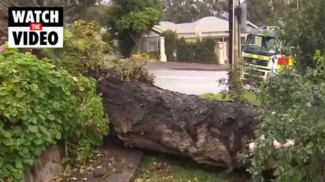
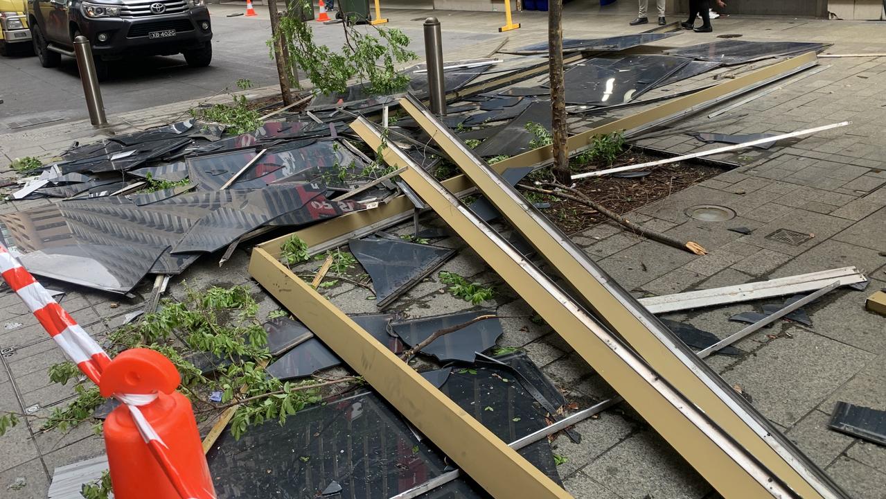
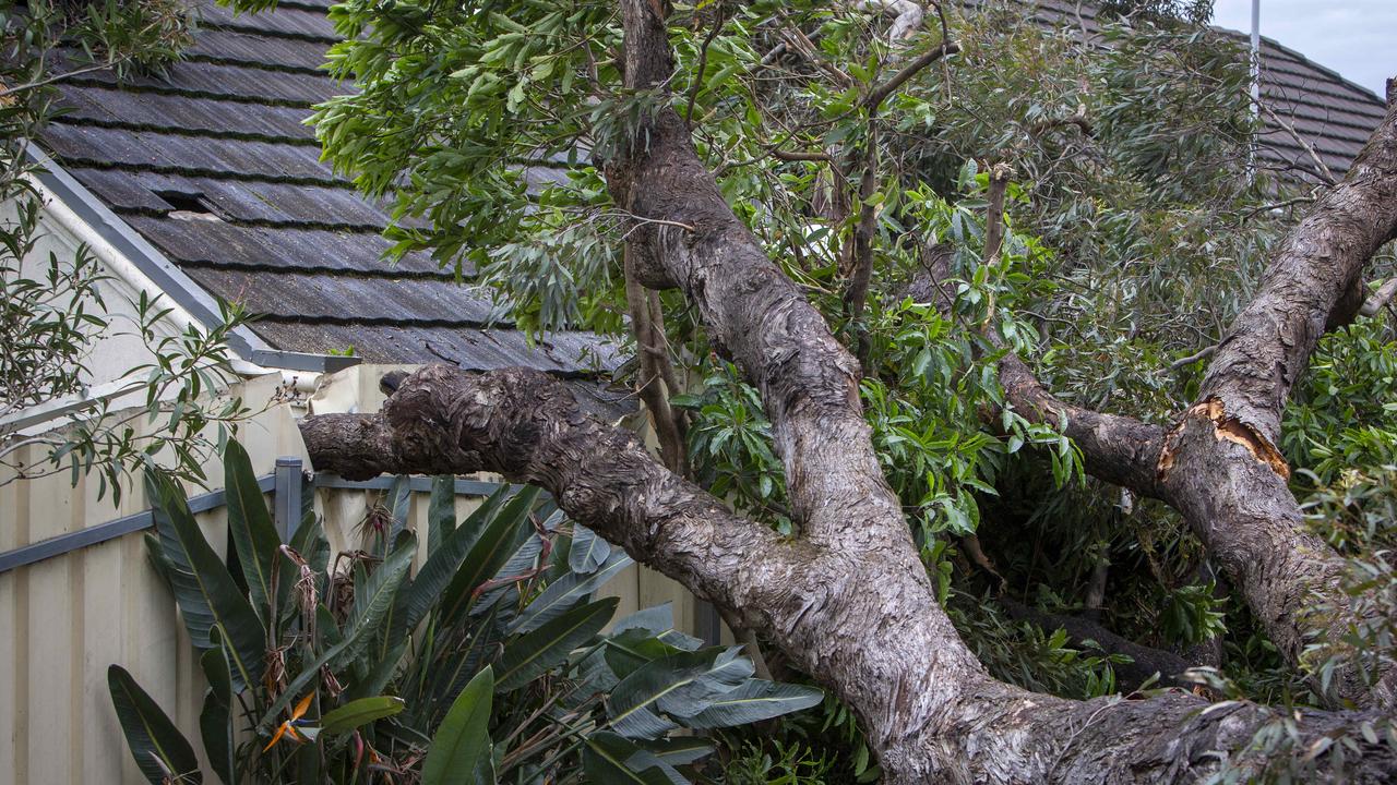
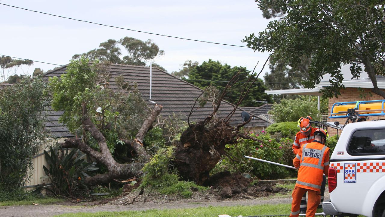
In South Australia, areas across Adelaide have suffered widespread damage, with downed trees crashing onto homes and parked cars, while the windows were blown out of the City Cross building near the Rundle Mall in the CBD.
Ferocious gusts caused glass and panels to plummet from the multi-storey building, leaving piles of debris in the middle of the walkway.
The incident happened in the early hours of Wednesday morning, with Adelaide City Council workers cleaning up the scene as the public started to make its way into the city.

More than 13,000 South Australians were left without power on Tuesday after damaging wind gusts of more than 80km/h were recorded.
State Emergency Services responded to around 75 calls for assistance from noon to 5pm on Tuesday.
There were 79 new incidents as of 12.30am on Wednesday, mainly for fallen trees and power lines.
The immediate threat of severe weather passed overnight on Tuesday, but the BOM will continue to monitor the situation and further warnings will be issued if necessary.
A strong wind warning is active for the Central and Lower South East coasts.
The wind also caused a crane to drop its load onto parked cars near a construction site in Hackney.
Nobody was in the cars or injured in the incident.
Several roads across Kangaroo Island have been closed, including the main road to the ferry terminal.
A severe weather warning has been issued by the BOM for parts of southeast Queensland, with a “serious concern for possible major flooding” developing in Burke.
“The rainfall over the coming days is likely to lead to renewed river level rises across large parts of southern Queensland, NSW and northern Victoria,” BOM senior meteorologist Dean Narramore said.
The main boom of a crane at Hackney construction site has buckled this morning, dropping its load onto nearby parked cars.
— 9News Adelaide (@9NewsAdel) October 5, 2022
Police are investigating the incident, which tore down power lines and left around 350 homes without power.
Thankfully, no one was injured.#9Newspic.twitter.com/a7DSDEMEQy
“Rain and thunderstorms are continuing across South Australia and Western Victoria on Tuesday.
“They are going to increase on Tuesday night and spread across southwest Queensland, much of NSW and northern Victoria on Wednesday, with widespread moderate to heavy falls,” he said.
Storms built up across outback Queensland and outback NSW through Tuesday night and into early Wednesday.
Records for the daily totals for the month of October are expected to be broken in parts of outback NSW.
“An additional round of rain and thunderstorms will move across NSW and Victoria and southern Queensland on Thursday night into Friday, leading to another burst of heavy rainfall with moderate to heavy falls,” Mr Narramore said.
⛈ï¸Thunderstorm Forecast for Tue: Severe storms possible for southwest QLD, most likely from afternoon. Heavy rain, flash flooding, localised damaging wind possible. Storms possible for western QLD tending to rain areas from evening.
— Bureau of Meteorology, Queensland (@BOM_Qld) October 3, 2022
Severe Warning current: https://t.co/pjs9WPAwxopic.twitter.com/uKzWrd5CMu
“This is likely to lead to even further river level rises across many of our saturated rivers, creeks and streams in NSW and northern Victoria and finally, a third burst of rainfall will sweep across southern Queensland, NSW and possibly eastern Victoria over the weekend, with further heavy rainfall, likely to further exacerbate already ongoing flooding across large parts of NSW, northern Victoria and southern Queensland,” he explained.
The system will run through into Friday, producing showers and storms for the country’s southeast, with a band of rain crossing Victoria and into NSW.
A surface low pressure system is expected to produce the heaviest rain for the event on Saturday night into Sunday morning across NSW.
The Bureau said it is “watching this forecast rainfall closely and will continue to update our forecasts and warnings regularly”.
“Many residents and communities that have already experienced flooding over the last few weeks are likely to see these flood conditions increase once again, particularly on and west of the ranges in NSW,” Mr Narramore warned.
“Residents and communities right across inland eastern Australia are advised to stay up to date with the latest forecasts and warnings via our website, app and social media and listen to all advice from emergency services in the coming days as the weather situation continues to change and evolve.”
Join the conversation

Albo’s power pledge to save Aussies $2300
Homeowners could see their yearly power bill slashed by up to 90 per cent following a new pledge by the Prime Minister.
Read more

Big change as daylight saving ends
Daylight saving ended in a number of Australian states at 3am Sunday morning. Here’s what you need to know.
Read more

Two states shaken by earthquake
A region between NSW and Victoria has been shaken by a “significant” 3.7 magnitude earthquake.
Read more