
Snow, ice, sludge force road closures as big freeze continues to bite
IT’S a little less wet, but plenty more chilly as the big East Coast freeze continues to bite.
KEEP the thermals handy — It’s a little less wet, but plenty more chilly as the big East Coast freeze continues to bite.
NSW and Victoria shivered through Friday night, and the mercury will stay low today — and plummet further tonight.
Snow and ice banked up to force the closure of some roads in NSW overnight, AAP reports.
NSW and Victoria are still bearing the brunt of the Antarctic-like cold front sweeping Australia with its capital set to have its coldest June in 18 years.
On Friday night it stretched its tentacles into southeast Queensland with gale-force winds leaving several thousand homes without power.
The cold snap is sweeping south and eastern parts of the country bringing flooding to South Australia, wild winds to Victoria and snow in alpine areas — and further afield up to the Blue Mountains, the NSW Central West, and NSW Northern Tablelands.
The Bureau of Meteorology (BoM)) says windy and icy weather affecting parts of the NSW central-west and the Blue Mountains will ease later on Saturday.
Strong wind warnings remain in place for Victoria, and gale force wind warnings are in place along the NSW Coast today.
8.4C #Sydney at 9am but with #WindChill feels like 0.9C! Stay rugged up at Sat morning sporthttps://t.co/oKWtjTX02w pic.twitter.com/V5Yj1IqZiF
— BOM New South Wales (@BOM_NSW) June 24, 2016
Snow reached far into the north on Friday night, with the New England Highway between Armidale and Glen Innes closed in both directions because of snow and ice.
The Great Western Highway between Yetholme and Marangaroo, west of Lithgow, has been closed, as well as local roads in Oberon and Jenolan.
But BoM forecaster Mohammed Nabi said while temperatures across much of the state would continue to fall, rain was not expected.
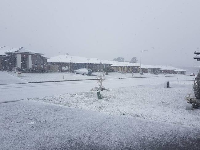
In Sydney overnight on Friday night, temperatures fell to 3C in the west and 8C in city. A top of 15C is expected in the city today.
Melbourne shivered through temperatures as low as 2C on Friday night. It was 4C at 9am Saturday.
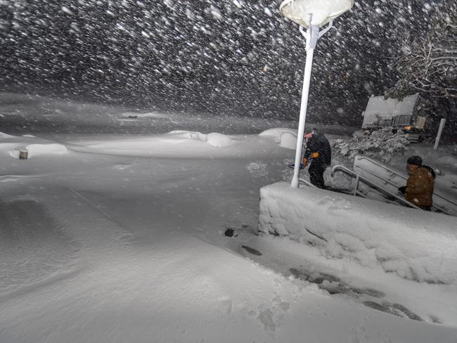
More snow fell in the alpine areas of Victoria and NSW, the Blue Mountains and central west NSW overnight, with the SES saying it had now turned to sludge in the lower Blue Mountains on Saturday morning, and renewing warnings for drivers to beware of black ice on roads.
In the NSW and Victorian ski fields there was about 5cm more snow overnight and lows of -7C.
It’s not expected temperatures which go below zero in those areas anytime soon.
Throw in the wind chill at Thredbo at 9am Saturday and that -7C felt like -16.8C. At Falls Creek in Victoria, -5.7C felt like -15.3C.
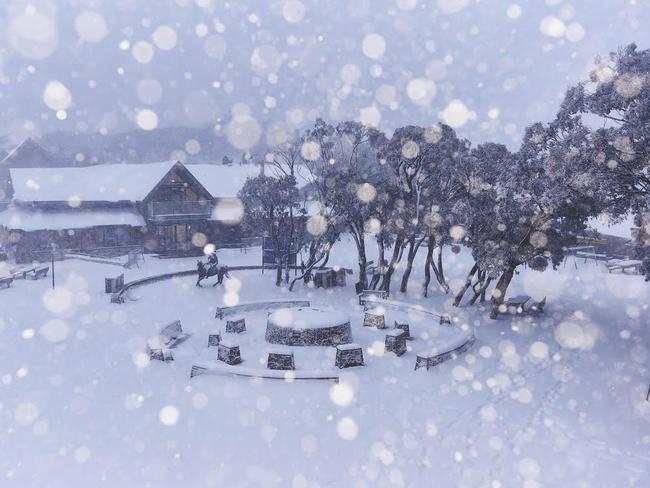
With over 70cm of snow this week, four resort areas are open today @PerisherResort #perisher @SubaruAustralia pic.twitter.com/Zqt39yXDL7
— Perisher Ski Resort (@PerisherResort) June 24, 2016
NEW SOUTH WALES
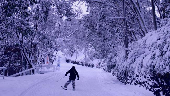
The blizzard-like conditions swept into NSW skifields on Thursday night dumping about 40cm of snow at Perisher and Thredbo by early Friday. By Saturday morning snowfall for the week was about 70cm.
Scattered snow is expected for the next couple of days, with temperatures dipping to -8C.
Snow has settled in Thredbo Village and had fallen all the way down to East Jindabyne at the foot of the NSW skifields.
But it wasn’t just ski resorts getting the falls.
Further north, heavy snow came to Orange, Oberon and the Blue Mountains as the front bit hard on Friday, but is easing to flurries today.
Mid-afternoon Friday, it was snowing at Blackheath, Katoomba, Wentworth Falls and Leura in the Blue Mountains, and further west, even briefly in Bathurst’s central business district. where the temperature plummeted to 0.8C.
The area around Polblue at Barrington Tops also copped a dusting of the white stuff.
While Sydney is sheltered from the worst of the chill, it’s still going to get cold enough to make the city feel as if things are a lot colder, with biting winds continuing today.
The mercury will struggle to reach 16C across the weekend and 15C on Monday with lows of just 7C overnight.
VICTORIA
AFTER Victoria froze through its coldest June day in almost 20 years on Friday, Melburnians can only expect slightly better weather conditions across the weekend,The Herald Sun reports.
The city is in for another two chilly nights, with minimum temperatures of 4 degrees in the early hours of both Saturday and Sunday morning.
Bureau of Meteorology duty forecaster Dean Stewart said there would be morning showers on Saturday in Melbourne’s southeast, including suburbs Dandenong, Pakenham and Cranbourne.
It will dry out in metropolitan Melbourne this afternoon. in the afternoon, remaining mostly cloudy with a top of 13.
As for Sunday, it will be dry across Melbourne with some sunny periods but we’ll only reach a top temperature of 12.
As for wider Victoria, there will be some isolated showers over southern Victoria on Saturday morning but it will dry out on Sunday.
Mildura will reach a top of 14 degrees on Saturday, while Bairnsdale and Orbost will reach 14 degrees on Sunday.
The icy-cold strong front meant the temperature struggled to hit double digits in Melbourne with strong winds making it feel more like zero during the day on Friday, and hitting almost zero overnight.
Snow was reported on Friday at locations including Lorne, Ballarat, Mt Donna Buang, the Grampians, the Great Otway National Park, the Dandenong Ranges and the Yarra Ranges in Victoria.
TASMANIA
Tasmania is slightly colder with a top of 9C expected today with further snow falls possible.
Last night the BoM issued several warnings across Tasmania as the cold front moved in.
Temperatures won’t get above 12C across the weekend with a low of just 3C expected tomorrow.
Statewide rain, heavy in N, easing tonight, but becoming very cold. Lots of warnings @ https://t.co/NHL3HY0zFO pic.twitter.com/aOH5CpOk2t
— BOM Tasmania (@BOM_Tas) June 23, 2016
SOUTH AUSTRALIA
This state won’t be spared either with a severe weather warning issued for the Riverland, Murraylands, Upper South East, Lower South East and parts of the Mount Lofty Ranges and Mid North districts.
Snow falls remain possible for the Mt Lofty ranges.
Adelaide temperatures will hover between 6C and 14C for most of the weekend with a high of 13C on Sunday.

Albo reconnects with Aussie icon in China
Anthony Albanese has gotten a big dose of panda diplomacy in China, reconnecting with an Aussie favourite as he winds down his state visit.

Greens demand PM act on toxic bloom
As one Aussie state continues to suffer from a “disaster” algae bloom that is putting the future of the fisheries industry in crisis, the Greens have made a simple demand from Albo.

‘Mind boggles’: Big call to bring back old tax
A former Treasury boss says the axing of a controversial tax “still boggles the mind” amid calls for stronger action to protect the environment.