
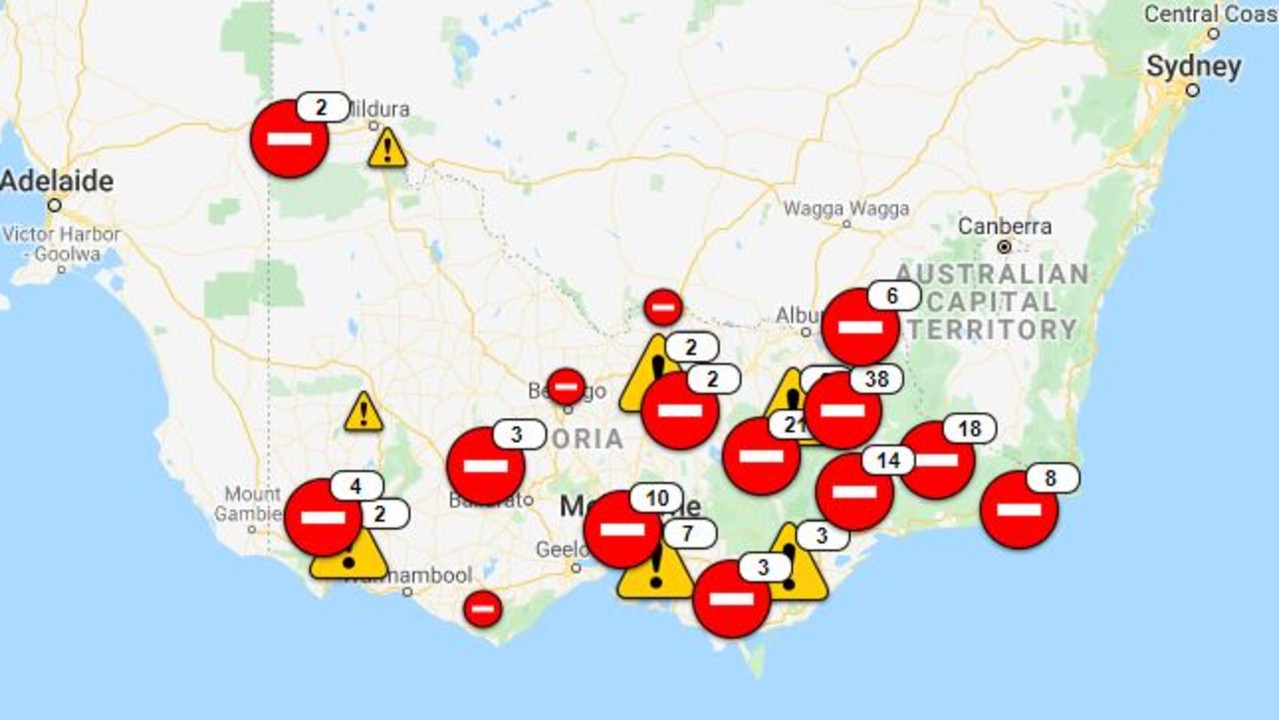
Major roads closed due to horror fire conditions
A risk of falling trees is among the hazards on roads and major travel routes in bushfire-affected parts of NSW, Victoria and South Australia
Some roads have reopened in bushfire areas, but others still remain closed and on Kangaroo Island warnings were issued of a “large risk of falling trees”.
The western end of Kangaroo Island still had areas of uncontrolled fire and within the burnt area a high risk to motorists and pedestrians of blackened trunks falling over without warning.
In Victoria, the Bogong High Plains Road was closed between Falls Creek and Omeo Highway due to fire activity.
In NSW, The Snowy Mountains Highway was still closed on Saturday due to bushfires between the Hume Highway and the town of Adelong in the NSW Riverina.
But the Hume Highway itself was open as conditions eased in Victoria and NSW, despite the merged mega blaze still burning south of the Snowy Mountains.
Motorists were also advised to be aware of the fact there was a grass fire at Beechworth-Wodonga Road in Wodonga.
The fire was under control with crew remaining at the scene, but heavy machinery was operating in the area.
Nearly 100 roads were closed over the past week in New South Wales and Victoria as horror fire conditions continued before relief brought by rain south of the border.
Now a warning of possible flash flooding has been issued by Victoria’s Police and Emergency Services Minister and VicRoads has stated that “no one should be travelling in the fire-affected areas”.
Last weekend, a bushfire at Voyager Point in Sydney’s west forced the closure of the M5 Motorway.
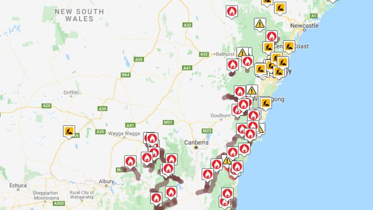
After a “horrendous” weekend of bushfires on the state’s south coast, the Southern Highlands and the Snowy Mountains, 136 fires continued to burn.
RELATED: Live coverage of Australia’s bushfires
VICTORIAN ROAD CLOSURES
In Victoria, the following roads were closed last weekend due to fire threat:
• Great Alpine Road is closed between Bright-Tawonga Road and Omeo.
• Lake Buffalo-Whitfield Road is closed from Buffalo River Road to Black Range Creek Road.
• Rose River Road is closed from Buffalo River Road to Upper Rose River Road.
• Lake Buffalo-Carboor Road is closed from Lake Buffalo-Whitfield Road to Gum Flat Creek Road.
• Buffalo River Road is closed from the Ovens River at Myrtleford to Lake Buffalo.
• The Princes Highway is closed between Orbost and the New South Wales border.
• Lake Buffalo-Whitfield Road is closed between Buffalo River Road and Warford.
• Murray Valley Highway is closed between Bullioh and Corryong.
• Mount Buffalo Road is closed from Porepunkah.
• Buckland Valley Road is closed at the Great Alpine Road roundabout at Porepunkah.
• Bogong High Plains Road is closed in both directions between Mount Beauty and the Omeo Highway.
• Brights Lane/Caellis Road is closed at Millwood Road.
• Tambo Upper Road is closed between the Princes Highway and Dukes Road.
• Upper Dargo Road is closed.
• Faithfuls Creek Road is closed.
• Dargo High Plains Rd is closed north of Kings Road, Dargo.
• Morses Creek Road is closed from Back Wandiligong Road.
• Euro-Strathbogie Road is closed.
• Tambo Upper Road is closed between Dukes Road and the Princes Highway.
• Engineers Road is closed between Great Alpine Road and Mount Baldhead Road.
• The Omeo Highway is closed between Omeo Valley Rd and Mitta Mitta.
• Mckillops Road is closed between Snowy River Road and Bonang Road.
• Murrungowar Road is closed between the Princes Highway and Metal Road.
• Dargo High Plains Road is closed between Great Alpine Road and Dargo.
• Kohnes Road is closed between the Omeo Highway and Fluerty Track.
• Mount Stirling Road is closed between Mount Buller Road and Circuit Road.
• Mount Buller Road is closed from Mirimbah to Mount Buller.
• Bluff Track is closed.
• Great Alpine Road is closed from Bruthen to Doctors Flat.
• Bogong High Plains Road is closed between Falls Creek and Omeo Highway.
• Nobs Track is closed.
• Refrigerator Gap Track is closed.
• King Billy Track is closed.
• Mt Eccles road is closed near Sparrows Road.
• Martins Road is closed between the Princes Highway and Waygara Road.
• Simpsons Creek Road is closed between the Princes Highway and Reeves Road.
• Cudgewa-Tintaldra Road is closed between Cudgewa and Tintaldra.
• Murray River Road is closed between Granya and Tintaldra.
• Benambra-Corryong Road is closed between Benambra and Colac Colac.
For the latest closures and to stay up to date, visit the VicTraffic map
RELATED: Bushfire relief: How you can help
NSW ROAD CLOSURES
In NSW, the following roads have been closed due to fire threat:
• Tabulam to Lower Duck Creek: Hootons Road and Paddys Flat Road are closed between Clarence Way and the Bruxner Highway.
• Adelong to Rosewood: Wondalga Road is closed between Rimmers Lane and Broadleaf Park Road
• Moruya: Francis St is closed at Bergalia St
• Greigs Flat to Eden: Nethercote Road is closed at the Princes Highway
• Conjola: Bendalong Road, Fishermans Paradise Road and Lake Conjola Entrance Road are closed from the Princes Highway
• Termeil: Boardinghouse Road is closed at the Old Princes Highway
• Braidwood to North Batemans Bay: The Kings Highway is closed
• Rylstone to Bylong: Bylong Valley Way is closed between Wollar Road and Lue Road
• High Range to Taralga: Wombeyan Caves Road is closed between the Old Hume Highway and Taralga Road
• Tomerong to Jerrawangala: Turpentine Road is closed between the Princes Highway and Braidwood Road
• Nowra Hill to Charleyong: Braidwood Road/Nerriga Road is closed between Albatross Road and Stewarts Crossing Road
• Moss Vale: Yarrawa Road and Mount Broughton Road are closed between Nowra Road and Werai Road
• Sutton Forest and Exeter: Exeter Road, Ellsmore Road and Sallys Corner Road are closed between the Illawarra Highway and the Hume Highway
• North Nowra: Illaroo Road is closed from Browns Mountain Road
• Tumut to Adaminaby: The Snowy Mountains Highway is closed between Tumut Plains Road and Adaminaby
• Bombala to Cann River (Victoria): The Monaro Highway is closed beyond the Victorian border
• Wentworth Falls: Tableland Road is closed from Yester Road
• Wingello: Highland Way is closed between Bumballa Road and the Wingello township
• Mogo to Moruya: The Princes Highway is closed between Tomakin Road and North Head Drive
• Khancoban to Jindabyne: Alpine Way is closed
• Jindabyne to Charlotte Pass: Kosciuszko Road is closed between Barry Way and Charlotte Pass
• Khancoban via Cabramurra to Paddys River: Swampy Plains Creek Road, Tooma Road, Snow Bridge Road, Goat Ridge Road and Elliott Way are closed between Alpine Way and Paddys River
• Braidwood to Cooma: Cooma Road is closed
• Jerangle (near Cooma): Peak View Road is closed between Jernagle Road and Numerella
• Hampton to Jenolan: Jenolan Caves Road and Edith Road are closed between Duckmaloi Road and Bastard Point Road
• Taradale to Rosewood: Broadleaf Park Road is closed between Taradale Road and Albury St
• Basin View: Wool Road is closed between the Princes Highway and John Street
• Cobargo: Cobargo Bermagui Road and other local roads are closed at the Princes Highway
• Adelong: Grahamstown Road is closed between the Snowy Mountains Highway and Hume Highway
• Kosciuszko National Park: Link Road is closed between the Snowy Mountains Highway and Goat Ridge Road
• Paddys Flat to Narrabarba: Imlay Road is closed between the Monaro Highway and Princes Highway
• Holbrook: Jingelic Road is closed between Holbrook and the Jingelic Township
• Bombala to the Victorian border: Delegate Road is closed between the Monaro Highway and Bonang Road in Victoria
• Ingebirah to Victorian border: Barry Way is closed
• Genoa to Cann River: The Princes Highway is closed
• South Pambula to the Victorian border: The Princes Highway is closed between Mount Darragh Road and the Victorian border
• Gilmore to Tumbarumba: Batlow Road is closed between the Snowy Mountains Highway and Kent St
• Mount Adrah to Gilmore: The Snowy Mountains Highway is closed between Mount Adrah and Batlow Road
• Myrtle Mountain (NSW far south coast): Myrtle Mountain Road is closed between Mount Darragh Road and Candelo
• Bucketty to St Albans: Wollombi Road/Great Northern Road is closed
For the latest closures and to stay up to date, visit the Live Traffic NSW website
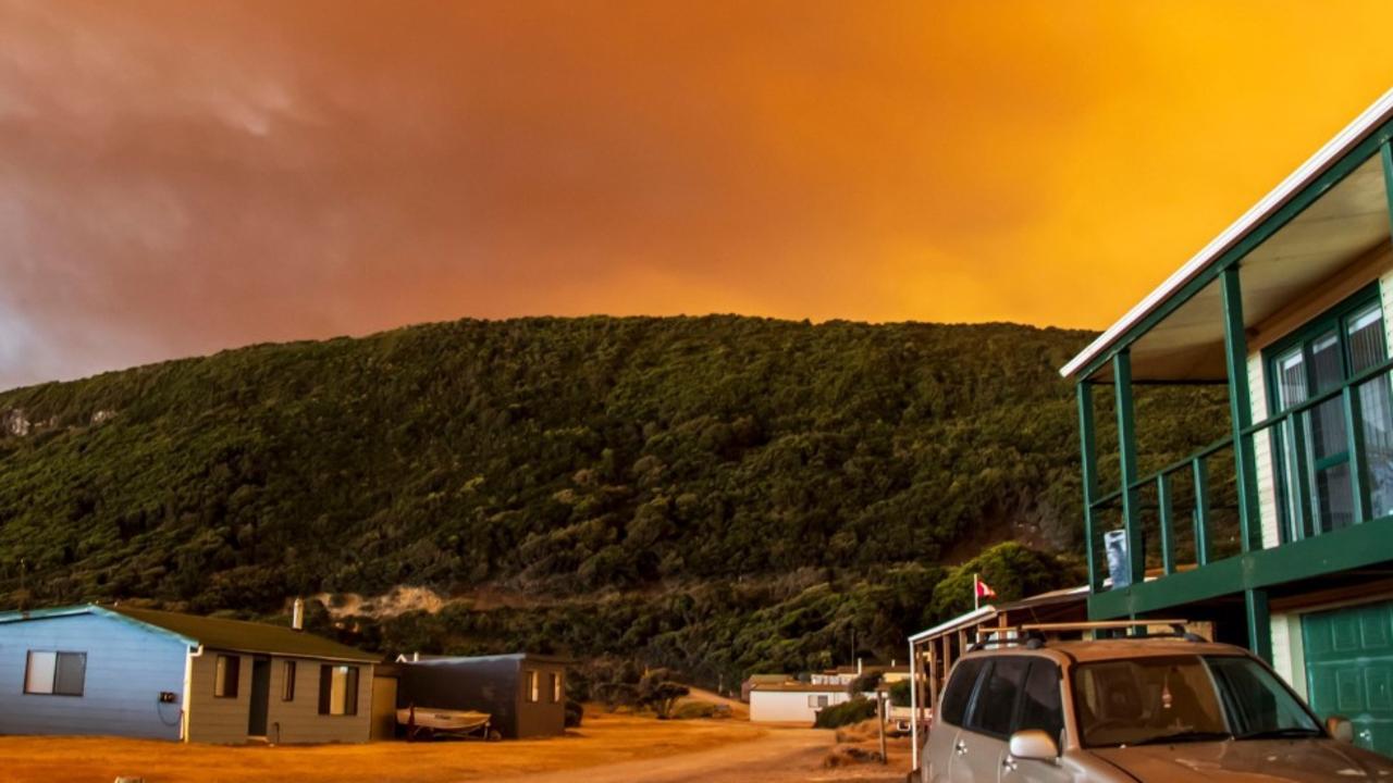
‘Volcanic’: Aussies battle raging fires
Residents in one state have captured startling photos showing apocalyptic scenes as they confront a complex web of bushfires.

‘Go home’: Albo heckled by angry mob
The Prime Minister was booed by activists fuming over wind farms while greeting supporters at a media event on NSW’s South Coast.
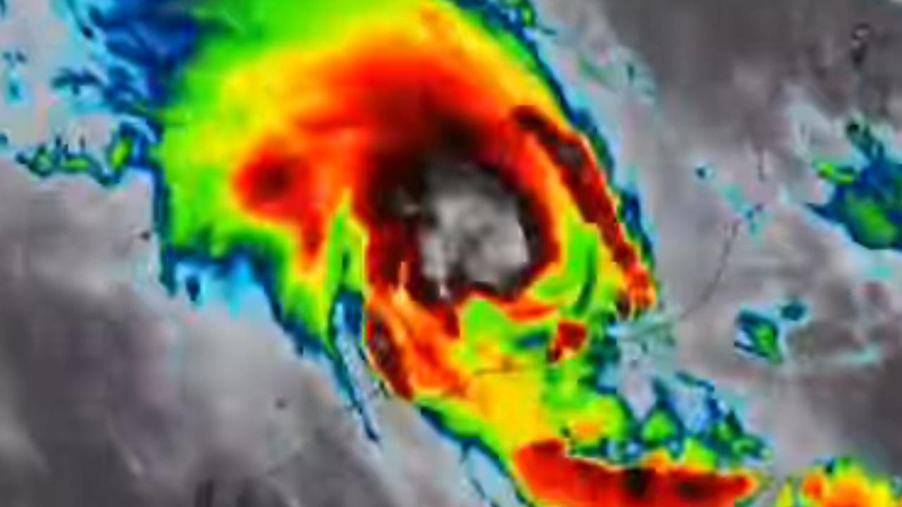
Massive category 5 cyclone crosses coast
One of the most powerful cyclones in Australian history has crossed the coast, with authorities warning of huge winds and up to 300mm of rain in 24 hours.