
Lack of rain and soaring temperatures – the bushfire threat isn’t going anywhere
If you think the bushfire threat has eased – think again. A weather system all the way in the Indian Ocean is hampering efforts to damp down the flames.

Forecasters have warned the bushfire risk is not over, and while conditions may have eased from yesterday’s scorching highs, there are worrying signs on the horizon.
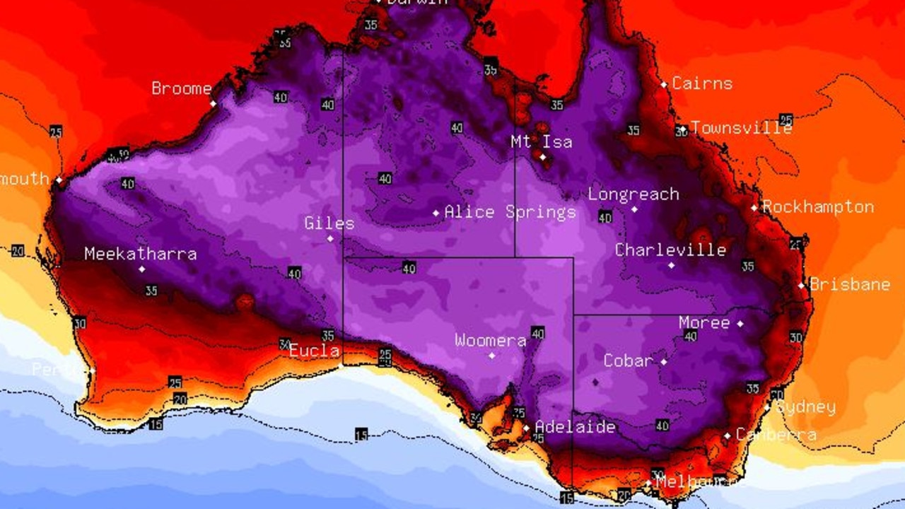
Temperatures will “increase dramatically once again” next week. Just take a look at the map below. The purple area is a band of air, above 40C in temperature, bearing down towards the east coast on Tuesday.
Weather systems in the Indian Ocean and to the south of Australia are combining to block the rain getting to where it’s needed most.
Immediate attention, however, turns to southeast Queensland, which is set for another scorching day as the cold front that stoked up fires in NSW heads north.
Brisbane could hit 33C today, and smoke haze is expected to be widespread before the winds arrive in the middle of the day.
Much of the southeast of the state is in the grip of severe fire danger, as is the Darling Downs and Granite Belt.
Residents north of Rockhampton in the path of a raging bushfire have been warned to prepare to leave as conditions worsen, AAP has reported.
“The fire is expected to have a significant impact on the community,” the Queensland Fire and Emergency Services said early on Wednesday.
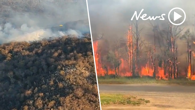
South of the Tweed, 950 firefighters are on the ground and 200 homes have been destroyed. Yesterday afternoon several suburbs of Sydney erupted in flames and 1.1 million hectares of land have been burned across the state.
Today, temperatures in Sydney will top out at 23C, some 15 degrees cooler than yesterday’s CBD high of 36.1C.
Residents of Taree on the NSW mid north coast, the epicentre of the worst bushfire damage, can expect highs of 26C.
“The fires will ease back but they will be still be quite substantial on Wednesday, and it will be difficult for firefighters to stop them entirely,” Sky News Weather Channel meteorologist Rob Sharpe said.
However, despite the cooler temperatures and lessened winds, there are still two things that are worrying weather watchers.
One is rain. Or the lack of it.
The second is a another bubble of hot weather, brewing up in Western Australia, that is ready to be flung across the desert at the east coast.
In terms of rainfall, very little is forecast across Australia, as can be seen from a stark map (below) from the Bureau of Meteorology.
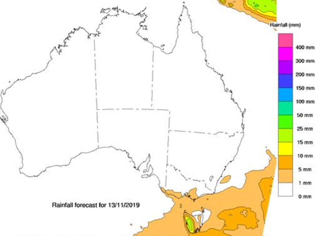
The mercury might be falling but the rain gauge shows no sign of rising by more than a drip or two.
The Indian Ocean Dipole, the equivalent of El Nino/La Nina but on the other side of the continent, is blocking rain and leading to drier conditions.
At the same time a negative Southern Annular Mode which is bringing hotter conditions to eastern Australia but cooler and wetter weather in Tasmania.
They are likely to break down in summer which may mean more rain can push through in the coming months. But that doesn’t help the situation right now.
For the next four days, the west coast of Tasmania is about the only place where any significant showers will occur.
Sunday is the first day where there is a chance some rain will fall in NSW. Even then it might only be on the coastal fringe, and if it does fall, there won’t be much of it to damp down the flames.
Concerningly, the heat will have returned by Friday as another cold front marches across the desert.
“Next week we may see the heat increase dramatically once again with temperatures soaring into the mid-30s in NSW,” Mr Sharpe told news.com.au.
Friday could reach 30C in Sydney, 32C in Taree and 35C in Grafton. Brisbane will dip to 29C tomorrow but on Saturday it will be at 34C, which is higher than today.
Early forecasts for Tuesday predict as high as 37C in Moree and 33C in Newcastle and Tenterfield.
The only saving grace is the wind, which may be less blustery than this week and so should provide less energy for the fires to take hold and spread.
“An enormous proportion of the landscape particularly in northeastern New South Wales remains at risk as a result of these fires. It’s going to be a long effort yet. Many days, many weeks, indeed many months if we don’t get rain before we properly bring these fires under control,” RFS Commissioner Shane Fitzsimons said on Wednesday.
EVEN HOTTER IN WA, CHILLY IN VICTORIA
Across the Nullarbor, and Perth is right up there in the heat league. It’s an absolutely roasting week in Western Australia. Expect 36C on Wednesday and then, like a very hot record, it will get stuck in that groove until at least Saturday.
Sunday and Monday will likely hit 30C in Perth. Again, little in the way of rain.
Head towards the southeast and the weather is completely different. Melbourne is even facing a week of below-average temperatures. It could struggle to get above 20C on the weekend, and there’s the possibility of a few showers. Overnight lows could dip to just 9C.
It’s cooler still in a soggy Tasmania with a week of temperatures in the mid-teens.
Adelaide will hit 19C on Wednesday but could get as high as 27C on Monday. Again, little to no rain.
It’s sunny and 21C in Canberra on Wednesday, climbing on Friday to 27C where the mercury will stay for the weekend. Next week, it could nudge 30C in the capital.
It will be hot, sunny and dry in Darwin, topping out at 35C.

Reason housing crisis could get worse
Australians are already facing a shortfall of more than 640,000 affordable homes. There’s one reason that might get even worse.

Severe frost alert for Aussie farmers
Farmers are being urged to keep their livestock warm as a freezing start to winter puts animals at risk.

Aussie-first hydrogen servo opens
Australia’s first publicly accessible hydrogen service station has opened, in a huge move towards decarbonising commercial vehicles.