
Rare weather phenomenon covers Queensland beach as storm front hits
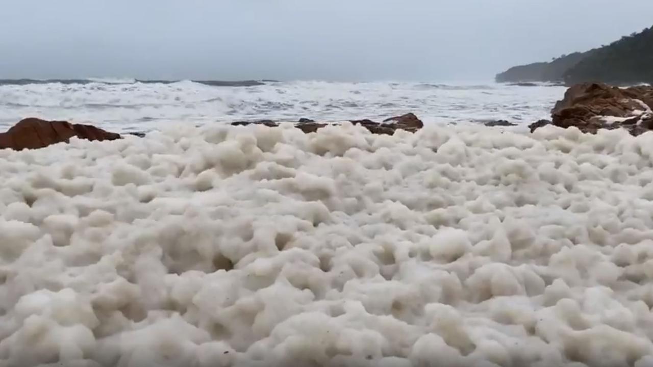
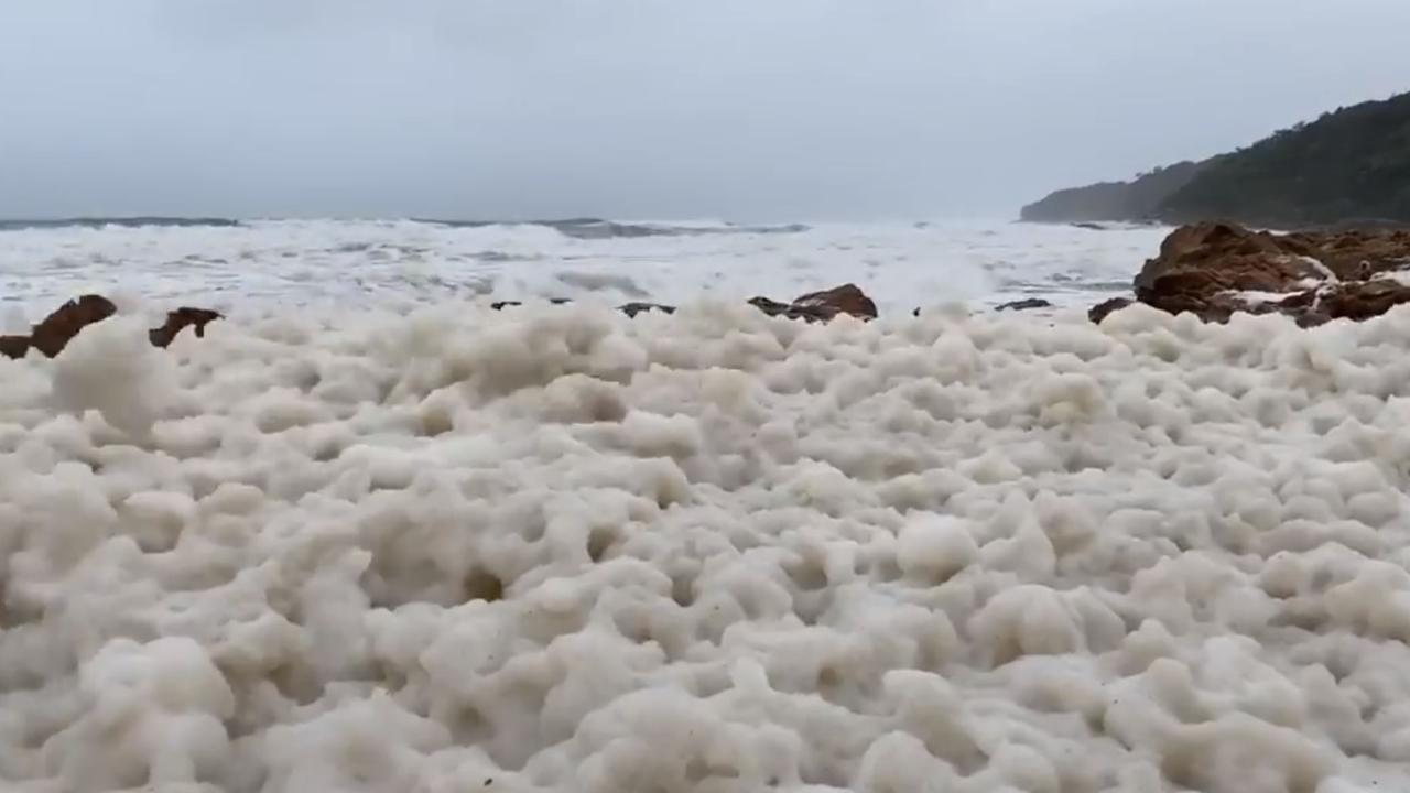
Jaw-dropping footage shows a Queensland beach coated with a lathery white substance – as experts warn more weather chaos is coming.
Wild scenes of sea foam overtaking a Queensland beach have emerges as residents across a major stretch of Australia’s east coast are being asked to brace for more wild weather tomorrow morning.
Footage shows First Bay Coolum’s usually pristine beach completely encased in thick mounts of murky white foam, wobbling on top of the water in the aftermath of the brutal weather currently lashing the area.
But the sight isn’t a sign the savage weather is over – with a spokeswoman for the BOM warning there will be increased rain, wind and waves Tuesday morning
“Tomorrow, it does look at some point during tomorrow conditions will ease, probably not in the morning,” she said.
“The expectation at the moment is later in the day. But, certainly, tomorrow morning we’d be expecting some increased rain, wind and waves. The surf does look like it’ll hang around for a bit longer now.”
Karlene York from the SES said there have been over 900 requests for assistance over the course of this weather event with 160 of them being since 6pm last night.
“It’s been particularly busy night,” she said. “Most of the jobs we’re assisting with are fallen trees, leaking roofs and windows.”
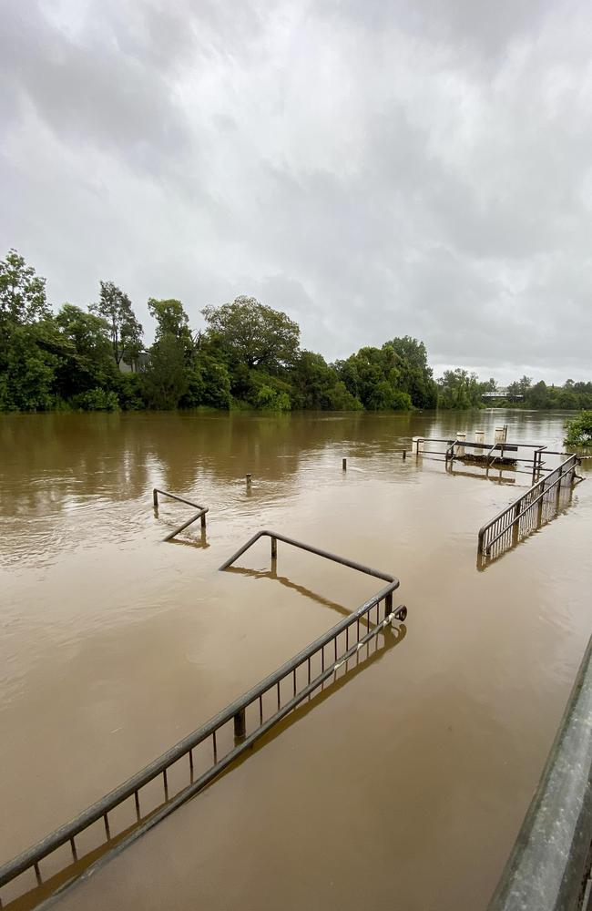
Homes and businesses are preparing to be inundated as flooding lashes parts of Brisbane and in the Gold Coast, wild winds are ripping glass panels from skyscrapers and flooding roads.
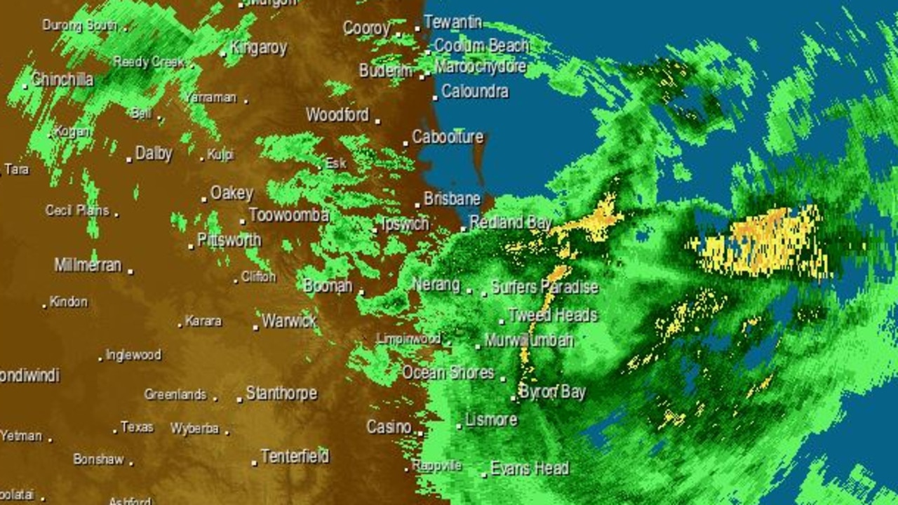
It comes after storm warning was issued across 1000km of Australia’s east coast this morning.
Winds of 104km/h have been clocked in Cape Byron this morning, and a high tide is hitting the Gold Coast causing flooding on the streets and reducing the Surfers Paradise beach to just a thin strip of sand.
Thousands there have been left without power and police have had to close roads in Surfers Paradise after glass panels were blown from a shelter of a high-rise pool deck.
Traffic is heavily backed up at Ferny Ave between Beach Rd and Elkhorn Ave as a result of the incident.
Meanwhile, pictures on social media show flooding at nearby Budds Beach — with cars trapped and roads inundated with water — and blackouts are hitting thousands in Labrador, Nerang and Southport.
Budds Beachã®ç¾å ´ã‹ã‚‰ã¯ä»¥ä¸Šã§ã™ðŸ˜‡ pic.twitter.com/HwbK1WROtR
— ゆã†ã„ã¡/Gold CoastðŸ³ï¸â€ðŸŒˆðŸ‡¦ðŸ‡º (@Horrie_Bradshaw) December 13, 2020
The dangerous weather and “relentless” rain is expected to continue up until at least Tuesday as residents are being warned to brace for damaging winds, flash flooding, heavy rainfall, “abnormally” high tides and disappearing beaches.
This morning a severe weather warning has been issued for a 500km stretch of the Queensland coast from Coolangatta to Hervey Bay and roughly 500km of coastline in NSW’s Northern Rivers mid-north coast regions, including the Tweed Coast and Byron Bay.
The warnings state there will be heavy rainfall, damaging winds, abnormally high tides and dangerous surf.
“Rainfall rates could be locally enhanced in the far north with thunderstorms, leading to the possibility of very heavy rainfall and dangerous flash flooding,” the NSW BOM warning reads.
“At this stage, the widespread heavy rainfall is expected to ease late Tuesday or early Wednesday, though thunderstorms may still produce localised heavy falls that may lead to flash flooding during Wednesday.”
It also warns of 90km/h winds along the coastal fringe north from about Yamba, possibly extending south to about Crescent Head on the Mid North Coast during the day.
There will also be waves exceeding 5m extending south to Port Macquarie during the day, possibly leading to significant beach erosion.
Abnormally high tides are expected along the coast north from about Ballina during this morning’s high tide, which may lead to localised coastal inundation.
South East Queensland is also being hit by the cyclone-like conditions, which worsened overnight with damaging winds and heavy rains battering the region.
Motorists have been warned to stay off the roads if possible with emergency services warning of flash flooding.
Locations which may be affected include Gold Coast, Brisbane, Moreton Island, North Stradbroke Island, Sunshine Coast and adjacent hinterland areas, Fraser Island, Caboolture, Cleveland, Redcliffe, Jimboomba, Beaudesert and Springbrook.
RELATED: Byron Bay’s Main Beach washed away
Monday will be the “critical time” for the affected areas as the trough moves further south and saturated rivers rise even further and the SES prepares for the worst in the first major La Nina event of the summer.
By Tuesday, three day totals of 300-600 ml are predicted to fall across the region.
Look at that energy! The system that's causing heavy rain & localised flooding in northern NSW is seen here gathering pace as it tracks south from Qld. People in affected areas are urged to keep up to date with latest warnings, & put safety first: https://t.co/0ikQE2NKzl@NSWSES pic.twitter.com/3yTyhAAueQ
— Bureau of Meteorology, New South Wales (@BOM_NSW) December 13, 2020
Authorities are urging caution and to prepare for local flooding as a trough deepens and moves away from southeast Queensland in the coming days.
“The community should prepare for minor to major flooding so please check for warnings and updates over the coming days,” BOM meteorologist Jonathan How said.
“This is the most significant rainfall event since February and floods will pose a risk to many people.”
Overnight, there were over 700 SES call-outs, with the busiest areas being the Mid North Coast and northern New South Wales regions. RFS and Fire and Rescue crews were on standby as winds averaging 60-70 km/h and gusts exceeding 90 km/h were predicted along the coastal fringe north from the beachside town of Yamba overnight, and possibly extending south to about Crescent Head on the Mid North Coast Monday.
âš ï¸ #Minor to Moderate Flood Warning issued for the Tweed River at #Tumbulgum and #Chinderah (Barneys Point). Minor to Moderate flooding is possible along the Tweed River. See https://t.co/9rNWfaCzgu for details and updates; follow advice from @NSWSES. #NSWFloods pic.twitter.com/mHq3ZURPZT
— Bureau of Meteorology, New South Wales (@BOM_NSW) December 13, 2020
âš ï¸ NSW SES is contacting residents in the Tweed / Byron area to let them know about the heavy rain and dangerous flash flooding expected overnight. More info: https://t.co/OFbQgz7qym For emergency help in floods and storms, call NSW SES on 132 500, or if life-threatening call 000
— NSW SES (@NSWSES) December 13, 2020
WHERE IS IT COMING FROM?
The storm is coming out of a trough over the Coral Sea which is deepening offshore of the southern Queensland coast. It is expected to form en masse overnight and into Monday as it makes its way down the Far North Coast, through the Mid North Coast on Tuesday and further south on Wednesday.
“This system is likely to bring significant rainfall, strong winds and large waves to the northern half of the coast until Tuesday,” warned the Bureau of Meteorology.
Streets in Coffs Harbour and Tumbulgum flooded over the weekend while four people were rescued from floodwaters in NSW on Saturday night.
HEAVY RAIN
A late night message from the Bureau of Meteorology predicted heavy rain “is expected to become severe again over the Northern Rivers from Monday morning and parts of the Mid North Coast during the day.
“Rainfall rates could be locally enhanced in the far north with thunderstorms on Monday, leading to the possibility of very heavy rainfall and dangerous flash flooding.”
The rain is expected to fall until at least late Tuesday or early Wednesday in the region but the addition of thunderstorms could spell flash flooding on Wednesday.
Some areas on the Gold Coast and northern NSW border recorded more than 350mm of rain since Saturday. More than 400mm of rain fell in Numinbah, a rural locality on the Gold Coast.
WHAT’S HAPPENING ELSEWHERE
In NSW, the wild weather will be contained to the north. In the southeast it will be cool-to-mild today with showers coming tonight.
Sydney has a possible shower today, with a low of 18C and a top of 25C.
Here’s a look at the other capitals around the nation.
Brisbane has heavy showers today, with a low of 20C and a top of 28C.
Canberrawill be cloudy, with a low of 12C and a top of 25C.
Melbourne will be sunny, with a low of 19C and a top of 32C.
Adelaide will be mostly sunny, with a low of 24C and a top of 34C.
Hobartwill be sunny, with a low of 14C and a top of 31C.
Perth will be mostly sunny, with a low of 12C and a top of 24C.
There’s a strong wind warning for Perth Local Waters, Pilbara Coast West, Ningaloo Coast, Gascoyne Coast, Geraldton Coast, Lancelin Coast, Perth Coast, Bunbury Geographe Coast, Albany Coast, Esperance Coast and Eucla Coast.
Darwin has a possible thunderstorm, with a low of 25C and a top of 33C.
BYRON’S BEACH SWEPT AWAY
The @Westpac Lifesaver Rescue Helicopter captured this footage of the dangerous surf conditions while flying over the Gold Coast Seaway today.
— Surf Life Saving Queensland (SLSQ) (@lifesavingqld) December 13, 2020
âš ï¸ Please stay out of the water. pic.twitter.com/UaYUPcjlSi
High tides have washed away the popular sandy Main Beach in Byron Bay as waves were seen crashing up against rocks, adjacent to a levelled footpath and road.
More of Australia’s beaches are under threat as damaging surf, with waves possibly exceeding 5 metres in the surf zone, were expected overnight from Yamba, then extending south to Port Macquarie during Monday and possibly leading to significant beach erosion.
The BOM also warned “abnormally high tides” are possible along the coast north from about Ballina during Monday morning’s high tide, which may lead to more localised coastal inundation.
“The combination of Damaging Surf and Abnormally High Tides may enhance the risk of significant beach erosion north from about Ballina,” the BOM said.
Surf and swell conditions are expected to be hazardous on Monday for coastal activities such as rock fishing, boating, and swimming in the following areas.
Swimmers and surfers have been urged to “stay out of the water and avoid walking near surf-exposed areas” by the NSW Police Force, Marine Area Command.
A hazardous surf warning is in place Monday for the Byron Coast, Coffs Coast, Macquarie Coast and Hunter Coast.
Main Beach in Byron Bay... gone! @9NewsSyd #NSWfloods pic.twitter.com/BWC6beCejy
— Hannah Sinclair (@hansinclair9) December 13, 2020
FLOODING
A flood watch is current for the Mid North Coast and Northern Rivers and flood warnings have been issued for the Tweed, Wilsons, Bellinger and Brunswick Rivers.
Locations which may be affected include Lismore, Grafton, Coffs Harbour, Port Macquarie, Sawtell and Dorrigo.
River flooding for the Mid North Coast and Northern Rivers is also expected with river levels to rise further from Monday and Tuesday.
High water levels due to spring tides are also forecast over the next few days, which adds to the risk of flooding in lower tidal areas.
Renewed minor to moderate flooding is possible along the Tweed River with the heavy rainfall forecast from overnight Sunday into Tuesday.
âš ï¸#Moderate #Flood Warning updated for the #Wilsons River at #Lismore. Minor flooding expected overnight Sunday and moderate flooding possible late Monday into Tuesday. See https://t.co/Q6MByhxSNz for details and updates; follow advice from @NSWSES. #NSWFloods pic.twitter.com/lLUEXf9KEd
— Bureau of Meteorology, New South Wales (@BOM_NSW) December 13, 2020
WHAT YOU CAN DO
The State Emergency Service advises has urged residents to move vehicles under cover or away from trees, to secure or put away loose items around your house, yard and balcony and to keep at least 8 metres away from fallen power lines or objects that may be energised, such as fences.
Residents are also warned not to drive or walk through flood water and to keep clear of creeks and storm drains.
“Be aware that run-off from rainfall in fire affected areas may behave differently and be more rapid. It may also contain debris such as ash, soil, trees and rocks,” the SES said.
* “After bushfires, heavy rain and the loss of foliage can make the ground soft and heavy, leading to a greater chance of landslides.
“Stay vigilant and monitor conditions. Note that the landscape may have changed following bushfires.

200 species dead in ‘unprecedented’ disaster
Scientists have offered a grim outlook for Aussies hoping for an immediate solution to an ‘unprecedented’ disaster leaving the water at Aussie beaches toxic.

City soaked in ‘wettest day of year’
One Australian city has just experienced its wettest day of the year thanks to a wild and wet cold front that is still lingering in the state.

‘Big’: Wild weather warning to Aussies
Aussies in several states have been warned to brace for a weekend of wild weather, with the risk of floods and damaging winds.