Wild scenes as Byron Bay inundated by floodwater
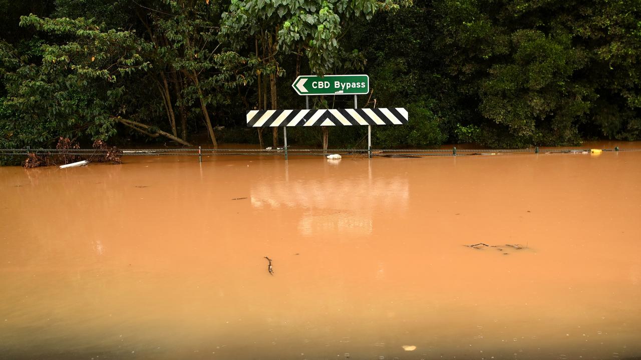
Insane pictures are emerging from Byron Bay, revealing the iconic main street now completely underwater as flash flooding wreaks havoc.
One of the nation’s most beloved tourist hot spots has been engulfed by floodwaters as wild weather lashes the east coast.
Insane pictures and footage is emerging from iconic Byron Bay, revealing the main street is now underwater.
Rattled residents have shared alarming photos of the carnage on social media, revealing extensive damage.
Stream more news on the floods with Flash. 25+ news channels in 1 place. New to Flash? Try 1 month free. Offer ends 31 October, 2022 >
Good morning, Byron Bay. Stay safe everyone. (Photos thanks to Tobias Haack) #ClimateEmergency#NSWFloodspic.twitter.com/IgUVMlok1E
— Daisy Dumas (@daisydumas) March 29, 2022
Flooding at Main Street, Byron Bay this morning. 📸 Reg Songaila @nbnnewspic.twitter.com/cDnpnZRir1
— Josephine Shannon (@Josie_Shannon_) March 29, 2022
Byron bay last night. #floods2022
— Costin Heaps 🌈 💉x 3 (@DianneCostin) March 29, 2022
That’s Great Northern Pub in the background pic.twitter.com/JLuFJ1Gr6U
According to Richmond Labor MP Justine Elliot, whose electorate covers flood zones including Ballina, Byron Bay, Mullumbimby and Tweed Heads, Lismore was the only region to receive official SES weather warnings.
But Ms Elliot claims her electorate “urgently” needs evacuation centres in Byron Bay and Ballina as the situation escalates.
In an emotional Facebook post, Ms Elliot – who is attempting to fly back to the North Coast immediately from Canberra, as Parliament has been sitting this week – said she had been “up all night watching this devastating flooding throughout our region”.
She described the disaster as “truly heartbreaking”.
BYRON BAY flooding after copping a drenching overnight. @nbnnews@9NewsSydpic.twitter.com/Pz6rJCDFMx
— Gracie Richter (@GracieRichter) March 29, 2022
Levee breached
Meanwhile, a new evacuation order was issued for Lismore overnight, with residents from the CBD, Lismore Basin, East Lismore and Girards Hill told to leave immediately.
The town’s levee overtopped at around 9am this morning, with the Bureau of Meteorology warning it could reach 12m by this evening.
The NSW SES earlier warned that the levee overtopping was “imminent” – but that the sirens would not sound due to a “malfunction”.
“Everyone must get out of the CBD immediately,” the organisation warned.
The SES also stated in an update that it had been “an incredibly wet and dangerous 24 hours” for the Mid North Coast, with many areas experiencing “heavy to torrential rain as well as flash and riverine flooding”.
The areas with the highest rainfall include Bellingen, which has received 305mm, Coffs Harbour at 227mm and Kempsey on 110mm.
Please wake up. We are in a climate emergency. We are now in a HYBRID CYCLONE. It’s frightening. The entire warning system was wrong we are underwater again and being smashed! Experts said we would experience HYBRID CYCLONES more regularly - the climate has changed. Sorry Lismore pic.twitter.com/U0TPSkCxRE
— Sue Higginson (@SueHigginson_) March 29, 2022
It’s the second evacuation warning to hit the embattled town in just two days, and comes after locals were free to return on Tuesday afternoon.
The BOM has also issued a severe thunderstorm warning for Coffs Harbour, with intense rain set to lash the city.
UPDATE: #SevereThunderstormWarning for intense #rain has been updated to include #CoffsHarbour and parts of #MidNorthCoast, the warning continues in parts of the #NorthernRivers.
— Bureau of Meteorology, New South Wales (@BOM_NSW) March 30, 2022
Monitor warnings: https://t.co/Ss766eSCrL
Radar: https://t.co/HG568kussZ@NSWSESpic.twitter.com/FysXBwiBfC
‘Worst fears have been realised’
State Minister for Emergency Services Steph Cooke has given a sombre update in a press conference alongside the SES, telling residents her “worst fears had been realised” in the wake of the floods.
“Unfortunately overnight, our worst fears have been realised with significantly heavy rainfall across already saturated landscapes, particularly across the Northern Rivers region and the Mid North Coast,” she said.
“It’s a special reminder and call out to communities to be very, very careful at this time as you move about, and we encourage you not to move unless you really need to at this time. “We should be treating all powerlines as if they are live.”
New evacuation orders
A string of new evacuation orders have been announced, with the NSW SES ordering residents of Woodburn and Swan Bay, Broadwater, Wardell, Cabbage Tree Island, Richmond River at Bungawalbyn and low lying areas of Coraki and New Italy to evacuate by 12pm this afternoon.
Parts of the lower Macleay region have also been urged to leave by 6pm today, after the Bureau of Meteorology predicted flooding along the Macleay River.
The order applies to people in low-lying properties at ï¸Belmore Rive, Sï¸mithtown, Gladstone, Kinchelaï¸, Jerseyville, Rainbow Reach, Summer Island, Maria River Road and those on low-lying properties on the Lower Macleay flood plain.
An evacuation order was earlier announced for residents in low-lying parts of the Urunga CBD, Bellinger Keys, Newry Island and Yellow Rock.
“This morning, we have seen the levee in and around Lismore start to overtop, and that will lead to additional flooding, compounded by the flash flooding environment that we saw overnight,” NSW SES Acting Commissioner Daniel Austin said during a press conference on Wednesday morning.
“That water will move its way down through the Wilsons and Richmond river systems, three communities as it works its way to the coast, we have already issued a number of warnings for communities downstream of Lismore to start to prepare, and put in their plans as this water makes its way towards them.”
Desperate search for missing woman
Police are desperately searching for a woman believed to be missing in floodwaters near Lismore.
Around 9.50pm last night, emergency services commenced a search and rescue operation near Wyrallah Road at Monaltrie, south of Lismore, following reports a woman had been trapped in her vehicle by floodwaters.
Police spent several hours searching for the woman and her vehicle, however they have been unable to locate her.
Officers from Richmond Police District – with assistance from Police Rescue, Water Police and NSW SES volunteers – recommenced a search and rescue operation this morning in the vicinity.
Police have again warned Northern Rivers residents to never enter, walk, ride or drive through floodwaters.
More floods coming in April
Sadly, it seems there’s no relief in sight for weary Northern Rivers residents, with Acting Premier Paul Toole warning more flooding was on the way within days.
“We are still expecting a very wet period over the coming months,” Mr Toole said.
“We may [have this] situation come back again in a week’s time. April is expected to be quite wet in many parts of the state.”
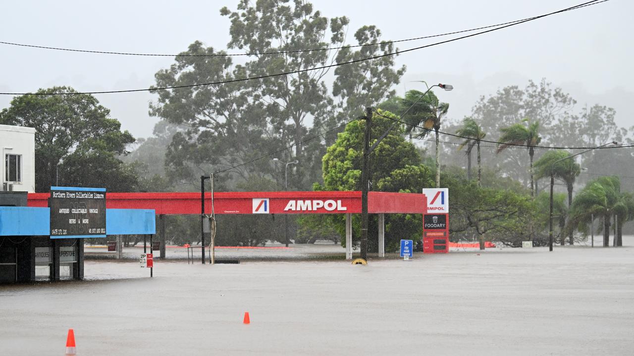
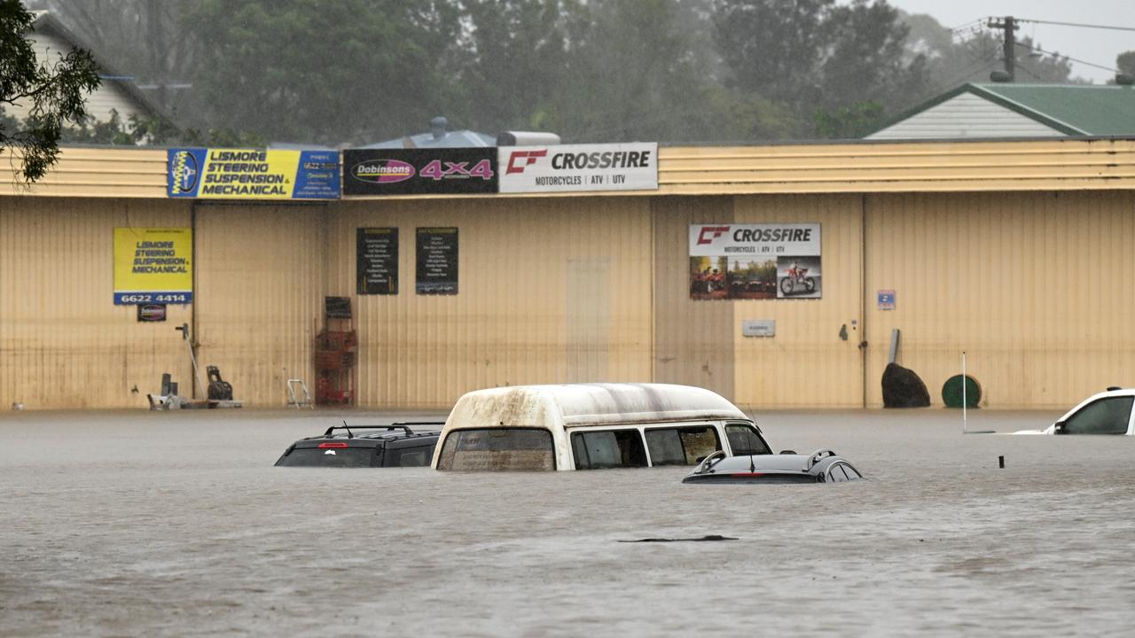
‘Hybrid cyclone’ warning
According to the Bureau of Meteorology (BOM), “intense rainfall” with thunderstorms are on the way for the region, with severe weather warnings and flood warnings also in place for much of northeast NSW.
But while authorities continue to claim the wild weather is a rare, freak event, public interest environmental lawyer and former CEO and principal solicitor at Environmental Defenders Office Sue Higginson has taken to social media to claim it was the result of a “climate emergency”.
Intense rainfall with #thunderstorms are forecast near Lismore, with a low pressure system just off the coast. Severe weather warnings and flood warnings are also current much of northeast NSW. Keep up to date with the latest warnings at: https://t.co/Ss766eSCrLpic.twitter.com/rmNkh6aiCu
— Bureau of Meteorology, New South Wales (@BOM_NSW) March 29, 2022
In a passionate Twitter post, Ms Higginson urged Australians to “please wake up”, warning we were now in a “hybrid cyclone”.
“It’s frightening. The entire warning system was wrong we are underwater again and being smashed!” she posted.
“Experts said we would experience HYBRID CYCLONES more regularly – the climate has changed.
“Sorry Lismore.”
But is there relief on the way?
Here’s what’s in store for the NSW east coast over the next few days.
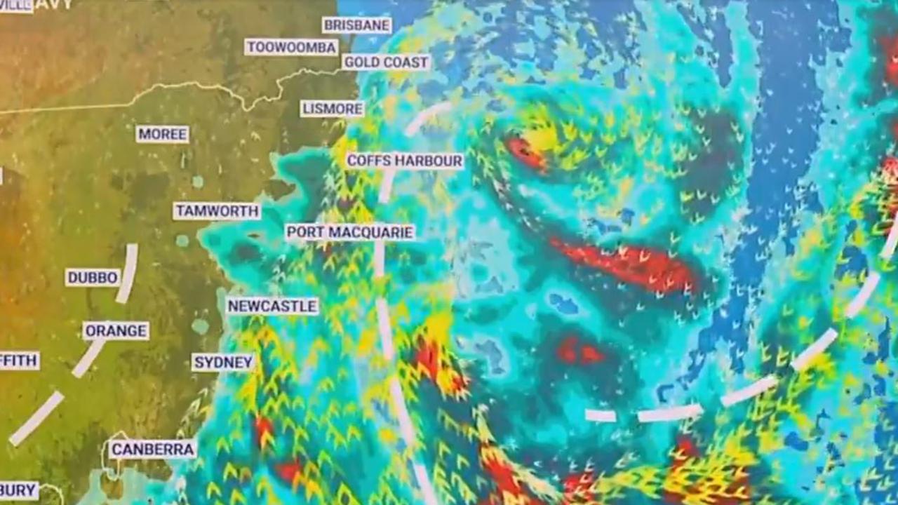
Weather forecast
According to the BOM, an area of low pressure, near the north coast, is “moving slowly southeast and deepening, with an associated trough affecting the east coast”.
A cold front and second trough will then hit the southeast today, before moving into the Tasman on Thursday.
The low will begin to move south, and by Saturday will be sitting off the coast, while western NSW will “remain under a ridge of high pressure throughout”.
Wednesday
Northern Rivers: There is a “very high chance of rain” – 95 per cent, in fact – for the area today, although that threat should ease by the afternoon and evening.
However, heavy rain is still possible, which could cause more flash flooding.
There’s also a chance of a possibly severe thunderstorm with “damaging winds and heavy rainfall”, with winds south-westerly of up to 45km/h.
“Large and powerful surf conditions” are expected to be hazardous for swimmers, surfers and rock fishers.
Sydney: The state capital is waking up to a cloudy day, with an 80 per cent chance of showers.
Winds will increase to up to 40km/h in the late evening.
Thursday
Northern Rivers: Things are looking much more positive tomorrow, with just a 20 per cent chance of a shower, and a possible thunderstorm near the coast.
However, dangerous surf conditions are still expected.
Sydney: Thursday will be partly cloudy for the city with another day of a high chance of showers.
A warning for “large and powerful surf conditions” in the early morning is also in place.
Friday
Northern Rivers: The end of the week will be partly cloudy, again with just a slight chance of a shower.
Sydney: Cloudy again with a high chance of showers, and southerly winds of 30 to 45 km/h.
Saturday
Northern Rivers: Finally, the weekend will kick off with mostly sunny conditions, with winds of up to 20km/h.
Sydney: Yet another cloudy day with a 70 per cent chance of showers, but while the city will cop south to south-westerly winds of 25 to 35km/h, they should decrease to 15 to 25 km/h during the evening.
Lismore evacuated
The new evacuation order was issued just after midnight, amid fears the town’s levee could exceed its maximum level of 10.6m.
Residents are urged to shelter with friends or family or move to the evacuation centre at Southern Cross University at Military Road in Lismore.
Ballina cops 100mm in an hour
Ballina has been hit by around 239mm of rain since 9am on Tuesday, with a staggering 100mm falling in just one hour.


