Images reveal devastation in tsunami-hit Tonga as government releases first official update
The first official details surrounding the volcano that exploded on the Pacific island nation of Tonga have been revealed — and they’re terrifying.

The first official details surrounding the volcano that exploded on the Pacific island nation of Tonga have been revealed, with a statement from its government describing a “volcanic mushroom plume” and waves reaching 15 metres high.
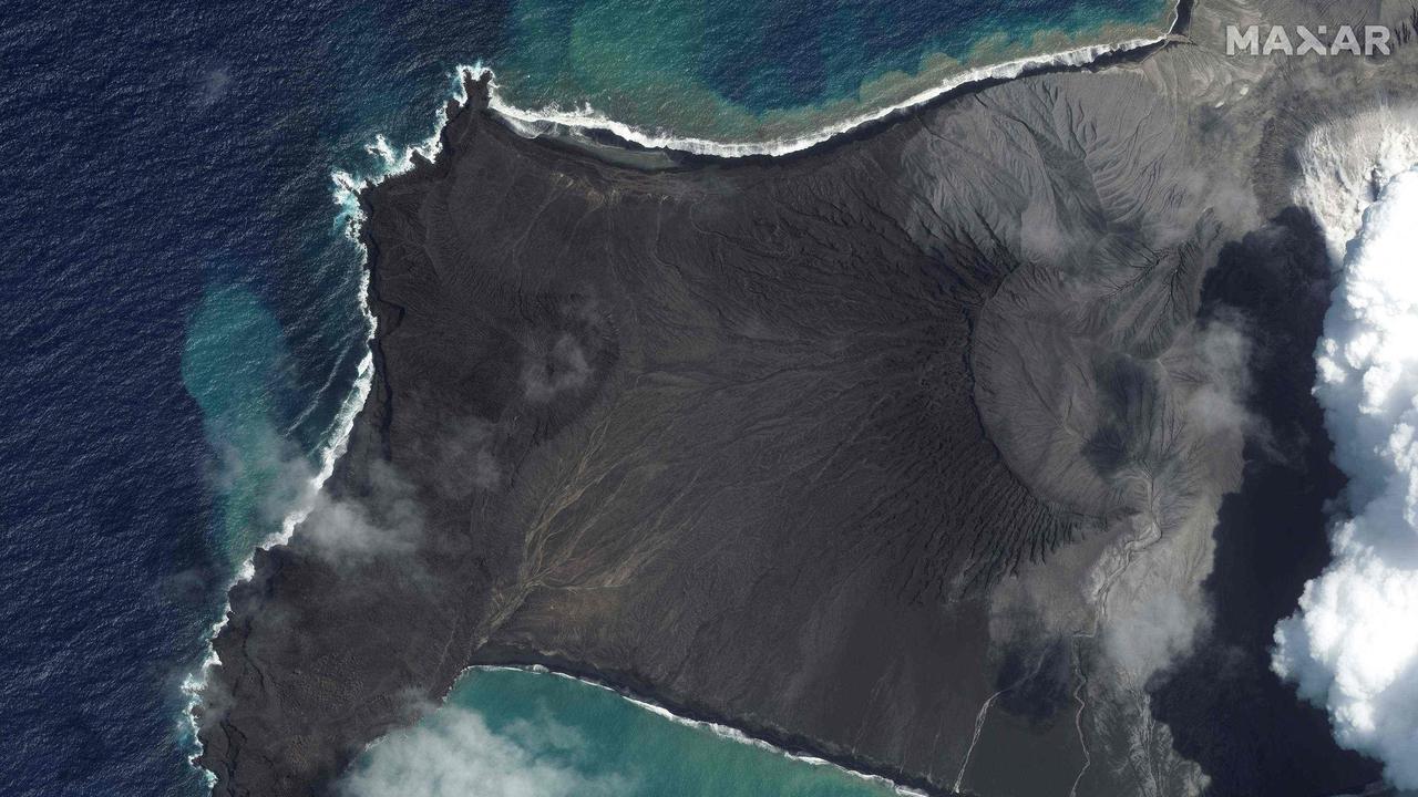
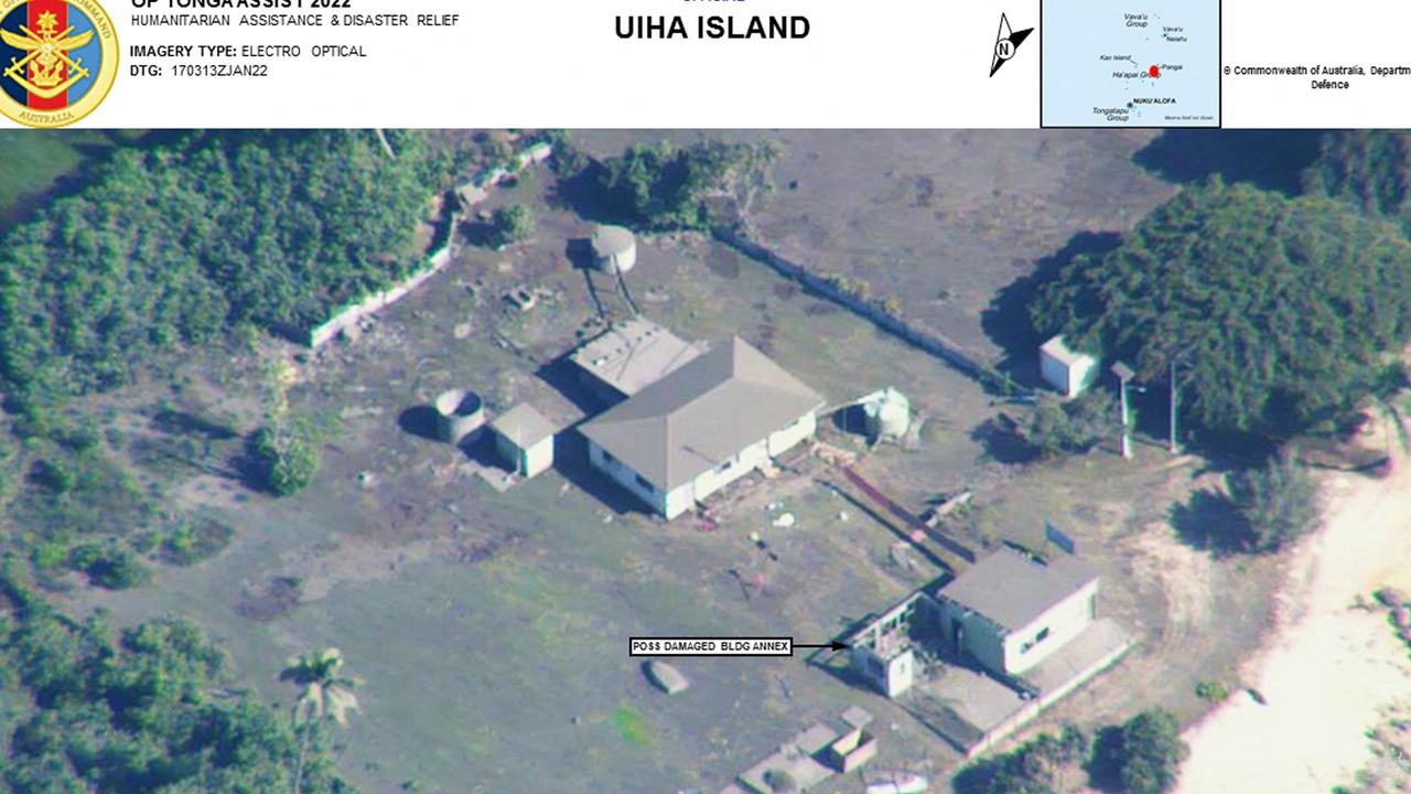
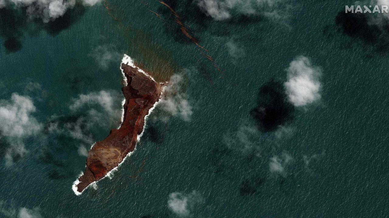
The volcano itself has almost disappeared from view, new images revealed, with swathes of the island nation smothered in grey ash and dust or damaged by a tsunami.
The government in Tonga overnight confirmed an additional death, taking the toll to three, and advised the public to remain indoors, use masks if going out and to drink bottled water due to the ashfall.
It described the volcanic eruption as an “unprecedented disaster” and said the three deaths were two locals and a British national; a 65-year-old woman, a 49-year-old man and British woman Angela Glover were killed in the tsunami.
Stream more environment news live & on demand with Flash, Australia’s biggest news streaming service. New to Flash? Try 14 days free now >
“As a result of the eruption, a volcanic mushroom plume was released reaching the stratosphere and extending radially covering all Tonga islands, generating tsunami waves rising up to 15 metres, hitting the west coasts of Tongatapu Islands, Ê»Eua and HaÊ»apai Islands,” the statement read.
NEWS📢 The NZ Government has released an update on New Zealand’s support to #Tonga âž¡ï¸https://t.co/01JrI41gNx#Force4NZ#NZAirForcepic.twitter.com/TeYAvdRJMR
— NZ Defence Force (@NZDefenceForce) January 18, 2022
A number of injuries have also been reported but the human toll remains largely unknown.
Smaller islands are now badly affected, with every house destroyed on Mango island and just two remained on Fonoifua island.
Around 2 cm of ash and dust has fallen on Tonga’s main island Tongatapu, raising concerns of air pollution and potential contamination of food & water supplies.
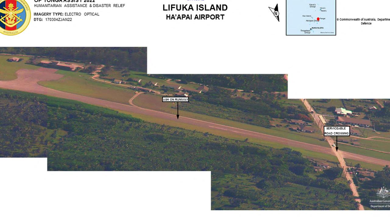
Around 200 volunteers have been helping to sweep airport runways of ash and debris so that flights can begin touching down to deliver aid and supplies.
Australia said the ash must be cleared before it can land a C-130 military plane with aid.

‘International and domestic communication severed’
Tonga has been virtually cut off from the rest of the world since Saturday’s volcanic blast — one of the largest recorded in decades.
The volcano erupted 30 kilometres into the air and deposited ash, gas and acid rain across a large area of the Pacific.
Three days after the eruption, the outside world is still scrambling to understand the scale of the disaster, using patchy satellite phone connections, surveillance flights and satellite images.
The blast severed an undersea communications cable between Tonga and Fiji that operators said would take up to two weeks to repair.
The government confirmed the submarine cable had sustained damage from the eruptions and limited commuciation had been made with Vavaʻu and Haʻapai. Internet remains down but priority is being given to restore domestic and international calls first.

Satellite images released by Maxar Technologies on Tuesday showed that where most of the volcanic structure stood above sea level a few days ago, there is now just open sea.
Only two relatively small volcanic islands were still visible above sea level after the eruption.
In fact, “what we saw above the water — that has now been destroyed — was only the tip of a volcano that had grown on the rim of the massive underwater volcano,” said Monash University volcanologist Heather Handley.
New Zealand released aerial images taken from a surveillance flight the previous day, revealing a tree-lined coast transformed from green to grey by the volcanic fallout.

‘Distress beacon’
Wrecked buildings were visible on the foreshore alongside others that appeared intact.
Volcanic ash blanketed island fields, images from an Australian Defence Force P-8A Poseidon patrol aircraft showed.
Shipping containers had been knocked over like dominoes at a port on the main island.
Australia’s HMAS Adelaide and New Zealand’s HMNZS Wellington and HMNZS Aotearoa were ordered to be ready for a possible aid request from Tonga, which lies three-five days’ sailing away.
With water sources feared to be poisoned by volcanic fallout, the Red Cross said it was sending 2,516 water containers.
France, which has territories in the South Pacific, pledged to help the people of Tonga’s “most urgent needs”.
The UN said a signal had been detected from a distress beacon on a low-lying island, Mango.
The UN Office for the Coordination of Humanitarian Affairs said surveillance flights had confirmed “substantial property damage” on Mango, home to some 30 people, and another island, Fonoi.
.@WHO is closely working with the Government of #Tonga and @UN agencies on the ground to support the response to the recent volcanic eruption and tsunami, and is being a central channel of information in the face of continued telecommunications outages.https://t.co/lRQJ1sKu4Yhttps://t.co/euOLeXWaNU
— Tedros Adhanom Ghebreyesus (@DrTedros) January 18, 2022
The UN agency also reported “extensive damage” on the western beaches of the main island Tongatapu, “with several resorts and/or houses destroyed and/or badly damaged”.
Tonga’s capital Nuku’alofa was shrouded in two centimetres of volcanic ash and dust, it said.
Power had been restored to parts of the capital. Local phone systems had been restored but international communications were severed.
#YourADF is pre-positioning #HMASAdelaide to Brisbane to provide additional humanitarian assistance and disaster relief if requested by the Government of Tonga, following the eruption of Hunga Tonga-Hunga Ha'apai on Saturday. 🇦🇺🇹🇴
— Royal Australian Navy (@Australian_Navy) January 18, 2022
📸: ABIS Susan Mossop #AusNavypic.twitter.com/Ec4XubS0Hh
The capital’s waterfront, the UN body said, was “seriously damaged with rocks and debris pushed inland from the tsunami”.
Satellite images released by the United Nations Satellite Centre showed the impact of the eruption and tsunami on the tiny island of Nomuka, one of the closest to the Hunga-Tonga-Hunga-Ha’apai volcano.
The satellite centre said of 104 structures analysed in the cloud-free area, 41 structures were identified as damaged.


Freak volcano waves cause horror
Saturday’s eruption was recorded around the world and heard as far away as Alaska, triggering a tsunami that flooded Pacific coastlines from Japan to the United States.
Peruvian authorities sealed off three beaches after they were hit by an oil spill blamed on freak waves caused by the volcanic eruption in Tonga.
The Pampilla Refinery, part of the Spanish company Repsol, said there had been a “limited spill” of oil off the coast of Callao and Ventanilla districts near Lima Saturday due to the violent waves produced by the eruption on the other side of the Pacific Ocean.
It said the spill occurred during offloading from a tanker.
The National Emergency Operations Center said in a statement that the spill had been brought under control.
Environment Minister Ruben Ramirez said the accident had affected a three-kilometer stretch along three beaches.
“There is great damage to biodiversity, and it could even impact human health,” he said.
“And so it has been ordered that the area is cut off for all kinds of activity,” Ramirez told reporters.


