
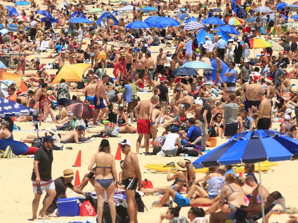
A scorching Christmas Day for Australia as heatwave rolls in
Today marks the start of a “very, very intense” heatwave across the country, and boy are Aussies starting to feel it as the mercury reaches 40C.

Southeast Queenslanders are enjoying picture perfect weather on Christmas Day but in the state’s north, persistent rainfall has made for a soggy celebration and out west, it’s getting hot.
On the Gold Coast temperatures are forecast to peak at a comfortable 28C, while in Brisbane, the mercury will hit 30C with low humidity, the Bureau of Meteorology says.
“Pretty nice and fine conditions for today and tomorrow, and right up to the weekend,” meteorologist Adipi Sharan said on Tuesday.
Beach-goers can expect a light easterly sea breeze that will swing to the northeast by Wednesday.
In the state’s north, however, showers and thunderstorms are lingering from Mackay right to the tip of Cape York.
Minor flood warnings have been issued for the Mulgrave and Russell rivers, south of Cairns.
“It will be pretty wet over the next few days in the north,” Ms Sharan says.
Watch the heatwave across the country. pic.twitter.com/FwXfQEqsqD
— Chris Smith (@crismith) December 25, 2018

A trough in the Coral Sea will continue to dump rain over the next week as it shifts west onto the coast, she said.
Rainfalls of about 100mm are expected in the Port Douglas and Cooktown areas, north of Cairns on Christmas Day.
In Cairns and Townsville temperatures are forecast to reach 31C, with rainfalls of about 50mm.
In southwest Queensland, weather conditions are fine, dry and hot with temperatures expected to rise over the next week.
Birdsville is forecast to peak at 43C for Christmas Day, while in Thargomindah it will reach 39C and in Charleville 36C.
Winds from central Australia are pushing warm air into the region and will trigger a low-intensity heatwave, Ms Sharan says.
“These hot temperatures will be lasting right through the weekend,” she said.
#Heatwave conditions expected with highest temperatures expected next weekend. Temperatures along the Murray likely to be in the mid 40's. See https://t.co/ijl11onM2A pic.twitter.com/Y9u7QQE16h
— Bureau of Meteorology, Australia (@BOM_au) December 23, 2018
WEST SCORCHER
Western Australians have faced the hottest temperatures so far today, with the Pilbara region peaking at 43C at 10.30am.
Telfer recorded 43.9C at that time, with the mercury tipped to have been even hotter since then.
Conditions are “very hot and dry” with gusty northeast to south-easterly winds through the southern Kimberley, inland Pilbara, inland Gascoyne and the northern Interior, with fresh and gusty sea breezes expected for the Gascoyne coast in the afternoon.
A severe fire sanger is forecast for Gascoyne, Kimberley Inland, East Pilbara Coast, East Pilbara Inland, Ashburton Inland and North Interior
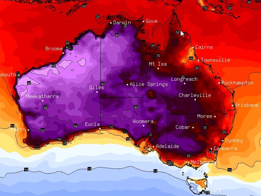
CHRISTMAS HEATWAVE
Whoever said they were dreaming of a white Christmas obviously never celebrated December 25 Down Under, because today Santa is bringing an absolute scorcher.
Heatwaves have been forecast for much of the country with some capitals expected to see runs of days all with maximums higher than 30C — and further inland you can expect more like 40C.
While conditions are expected to be calm through the week — meaning no more thunderstorms and golf-sized hailstones — it’s also going to be painfully hot.
“All of the models are predicting a ridge of high pressure for southern Australia for Christmas Eve, Christmas Day and Boxing Day,” Sky News Weathermeteorologist Tom Saunders said.
High-pressure systems generally lead to dry conditions and the sheer size of the ridge means its effects would be felt from Tasmania all the way to southern Queensland and southern Western Australia.
And we're in for a #heatwave over Xmas/NY in Sydney. Ugh! Temps up to 40C+ (104F+) pic.twitter.com/Wos4ddwXbS
— Sylvia Massara--Novelist (@sylviamassara) December 24, 2018
“This is the start of a prolonged and an intense heatwave. Widespread 40-45C heat, daily records potentially broken and longevity records could also be broken,” Sky News Weather meteorologist Tristan Meyers said.
“(It will be) very, very intense and at the very least it’s going to be the worst heatwave we’ve seen since January and it has the potential to challenge the heatwave of 2009 in the southeast.”
The Bureau of Meteorology has forecast heatwaves across swathes of Queensland, the Northern Territory and down into much of NSW for the Christmas period.
Duty forecaster Anita Dyne told AAP that in western NSW, Orange would reach 29 degrees while Broken Hill would hit 38 degrees today
South Australia will cop the strongest heatwave with temperatures in Adelaide expected to push into the 40s later this week. Towns in the north of the state, including Marree and Oodnadatta, are expected to hit 42C today.
The southern state will experience its first sustained period of hot weather this summer, with the mercury staying high across much of the state for at least the next seven days.
Meanwhile, Perth and Far North Queensland are also likely to be as hot as a Christmas turkey.
And in some inland Australian towns, heat records are set to be broken. Starting tomorrow, Coober Pedy is expected to have six days of 40C-plus weather with four of those hitting 46C.
Mildura, Victoria is also gearing up for a six-day heatwave from Boxing Day with the mercury struggling to drop below 40C.
It will be wetter in Northern Australia, with the remnants of Cyclone Owen still likely to be whipping up some rain.
“Over the next couple of days, Owen will go back north again (towards Cairns) but it’s not expected to develop back into a cyclone,” Mr Saunders said.
“There’s a chance of showers but just regular wet season storms and it won’t be enough rain to cause further flooding.”
Senior BOM meteorologist Claire Yeo said despite the “beautiful” days ahead, Aussies shouldn’t become complacent.
Christmas could mark the start of a low intensity heatwave inland, with temperatures increasing from the northwest coast of Western Australia extending down into the southeast, she said.
“When you have very hot temperatures bordering into that extreme and a lack of rainfall, it always leads to the potential of fire dangers increasing.”
Heatwave conditions expected to affect inland #Victoria from Boxing Day. Temperatures expected to exceed 40 degrees in the north and reach 45 degrees in the Mallee by Friday. Check your forecast at https://t.co/aViwyd715d pic.twitter.com/uOp2EHg27w
— Bureau of Meteorology, Victoria (@BOM_Vic) December 22, 2018
CHRISTMAS WEATHER AROUND THE CAPITALS
In terms of temperatures, today is looking generally warm, in some places very hot, across the south of the country with sunny days and blue skies.
Christmas Day in Sydney is looking like 29C and sunny. It will be 35C in western suburbs.
In the nation’s capital, Canberra is set for a maximum of 33C and sunny.
While Christmas Eve was a scorching 34C in Melbourne, today will cool slightly to a top of 26C.
Hobart will be cloudy for Christmas with a pleasant 22C maximum after a hot Christmas Eve.
In Adelaide, the high-pressure system could see the mercury top out at a blistering 35C on a sunny Christmas Day. Perth will match with a top of 35C as well. It will be part of a heatwave in the Western Australian capital with around six days above 30C, reaching 39C on Saturday.
In the Top End, Darwin won’t deviate from the norm, with thunderstorms and a top of 34C for Christmas Day.
Finally Queensland, and the BOM has Brisbane on 29C and partly cloudy for Christmas Day. Northern Queensland could be wet though with Cairns copping up to 25mm of rain today with a high of 31C, its seventh day above 30C. Townsville will also be at 31C but with less rain forecast.

‘Biohazard’: Rotting flesh on iconic beach
Locals claim pristine Tasmanian beaches are being overrun by a disgusting “biohazard”, sparking outrage and urgent calls for action.
How PM caused next cyclone to be renamed
The Bureau of Meteorology has had to make a rapid change as two potential tropical cyclones loom off Australia’s coast.

Innocent Aussie plant ‘worse than snakebite’
Aussie campers are being urged to steer clear of a deceptively ordinary-looking plant in the bush that can “stay in your skin for years”.