
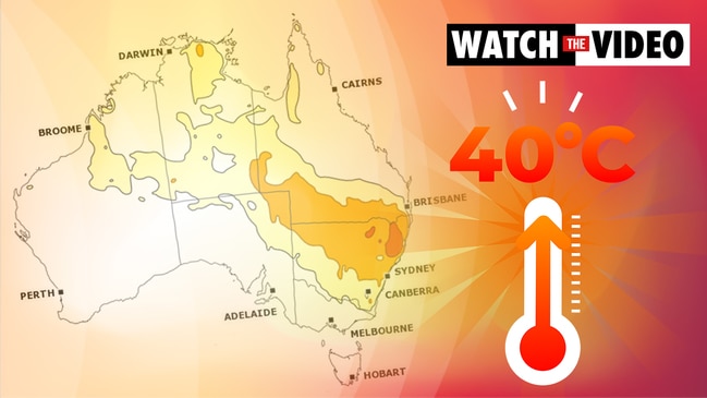
Heatwave across south east Australia could see records tumble, several 40C days
Millions have been warned to brace for temperatures well into the 40s while others are looking at several days above that, as a heatwave begins.

Weather experts have said this weekend’s forecast high in Sydney may need to be upped into the 40s as a horror heatwave sweeps in.
If the mercury pips 41.3C in Sydney’s CBD, Saturday will be the hottest day of 2020 so far for the city and hotter than any day in 2019. All-time spring weather records could fall elsewhere in New South Wales.
Adelaide is set to see multiple days at 40C. Some areas could see as many as six days above the 40C mark as baking air is drawn down from central and north Western Australia.
Sky News Weather Senior Meteorologist Tom Saunders said a “major late spring heatwave” was developing.
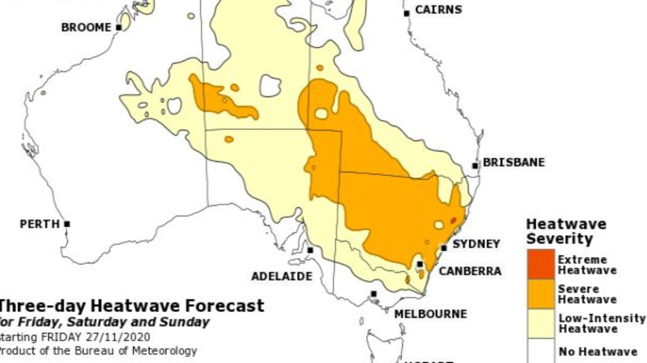
A heatwave is defined by the Bureau of Meteorology (BOM) as three or more consecutive days of unusually high maximum and minimum temperatures.
“Clearer skies have allowed the heat to build in the interior and now that is heading towards southern Australia due to a northerly and two high pressure system merging in the Tasman Sea,” Mr Saunders said.
RELATED: 4500km-long heatwave gets set to hit
SYDNEY A WORRY
That heat will peak first in South Australia with Adelaide looking at 40C highs on Friday and Saturday and overnight lows an uncomfortable 23C.
By Sunday, a cold front will see maximums sink to just 24C.
Head north, however, and the heat will linger in towns such as Tarcoola, Roxby Downs, Coober Pedy and Oodnadatta.
All these towns are looking at several days far above 40C. Oodnadatta could reach 47C on Saturday.
When it comes to major cities, Sydneyis the real worry. The CBD, which usually escapes the worst of the heatwaves, looks set to be punished this weekend.
The current forecast is for 33C on Saturday and 39C on Sunday, but Sky’s Mr Saunders said the city could easily breach those highs.
“The BOM may need to lift their Sydney 39C forecast to around 41C or 42C.
“With Tasman low pus a westerly across NSW it’s hard to see a (cooling) sea breeze developing,” he said in a tweet.
Richmond, in the city’s west, is looking at 40C on Saturday and 41C on Sunday. But if the CBD heats up further expect those upper limits to rise too. Saturday night could be a sweaty 23-25C across the Greater Sydney area.
Record high spring temperatures possible for inland SA, northern VIC & NSW this weekend. The BOM may need to lift their #Sydney 39C forecast to around 41 or 42C. With a Tasman low pushing a westerly across NSW it's hard to see a seabreeze developing. @SkyWeatherAUS @SkyNewsAust
— Thomas Saunders (@TomSaundersSNW) November 25, 2020
Monday should see a cool change across Sydney but there could be a second, albeit lesser, heat spike on Tuesday.
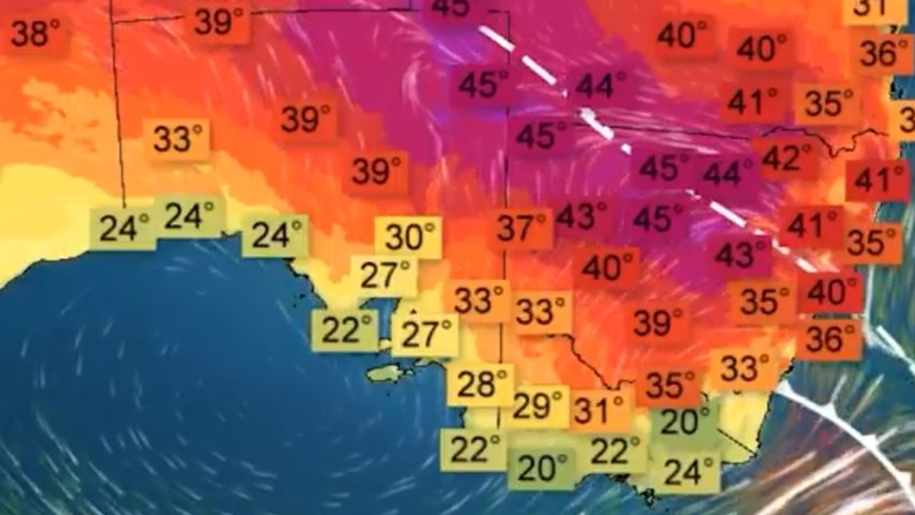
Toasty in the NSW interior with Griffith set to peak at 43C on Saturday and Dubbo the same, but on Sunday. Broken Hill could get to 44C on Saturday.
The state’s all-time spring record of 46.8C in Wanaaring, west of Bourke, could be beat this weekend, forecasters have said.
SIX DAYS ABOVE 40C
The south coast should escape the worst of the heat. That’s not the case in the north with an extreme heatwave due to move towards Queensland. Moree could see four days above 40C from Sunday, topping out at 45C on Monday and Tuesday. Overnight on Sunday it might not dip below 26C.
Brisbane is set to be steady and settled hovering around 30C for much of the weekend and into next week.
Inland areas around the state’s south will be hit by the heat though with St George looking at a run of 44C days from Monday, following 41C on Sunday. Birdsville could beat that with six consecutive days above 40C from Thursday with highs touching 46C.
#Queensland braces for another #Heatwave, starting in the west tomorrow, spreading across the southern interior this weekend and reaching the southeast coast by Monday. Records could tumble as temperatures reach the mid 40s. For details visit https://t.co/qiOcreXC3v. #QldWeather pic.twitter.com/z0s4Wm4gdu
— Bureau of Meteorology, Queensland (@BOM_Qld) November 25, 2020
MELBOURNE GETS A PASS, BUT NOT INLAND VIC
Lucky Melbourneis set to receive a ‘get out of heatwave free’ card with a southerly cooling down the coast.
The mercury will reach 33C on Friday in the city but then drop to 25C by 3pm on Saturday. There may even be rain on a mild 20C Sunday.
But away from the coast it’s a whole different story. Shepparton could break 40C on Saturday, Wodonga 42C and Mildura 44C. But most places in Victoria will see a dip into the high 20s on Sunday before the mercury rises once more on Monday.
Tasmania is generally sitting this one out. Hobart will get to a pleasant 27C on Friday but then it’s back down to the low 20s for the weekend with a possible shower or two.
Canberra will likely be spared the extremes felt to its west and north. The capital won’t break 30C until Saturday when it’s forecast to reach 33C then 31C on Sunday and back up to 34C on Tuesday.
Showers and storms in Darwin with highs of 34C and lows of 26C. Partly cloudy in Perth with sunny spells and very manageable maximums in the mid-20s for the weekend and into next week.
Women injured by lightning amid Anzac deluge
Two women have been injured in separate lightning strikes after one Aussie state was pounded by more than 200mm of rain over Anzac Day.

Millions facing long weekend washout
Long weekend plans could be under threat across swathes of the country as millions brace for heavy rain and thunderstorms.
Major city rocked by earthquake
People have rushed onto the streets after the city was hit by a 6.2 magnitude earthquake on Wednesday.