
‘Extreme weather ahead’ for many parts of Australia
No part of Australia is likely to be left untouched by a wild few days of weather with severe thunderstorms, searing heat, snow and flooding rains.

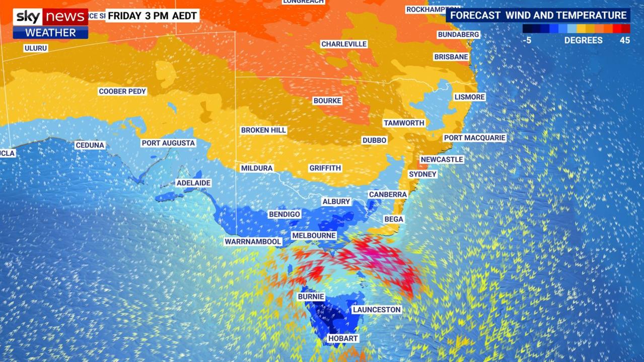
Meteorologists have zeroed in on their warnings of “extreme weather ahead” with wild storms spreading through every mainland state and territory before the end of the week.
Temperatures are expected to peak at 14C above average for this time of year in South Australia with Sydney hitting the mid-30s. At the same time, heavy rainfall, hail, humidity and flash flooding are also on the cards.
“Severe weather is likely in many parts of Australia over the next few days,” said Sky News Weather senior meteorologist Tom Saunders on Wednesday.
“Much of Australia has a chance to see thunderstorms with a band of storms shifting towards the east.
“That band of storms is due to a trough but we’re also expecting a low pressure system to form rapidly over the next 24 hours bringing severe weather to parts of south east Australia.”
Sucking in tropical moisture, this system is likely to lead to wet weather across Victoria and into Tasmania with strong to gale force winds and flooding. Temperatures could also plummet in Tasmania and coastal Victoria.
‘Organised and severe storms’
“Extreme weather is ahead,” said Bureau of Meteorology meteorologist Sarah Scully.
“It’s on Friday that we’ll see the peak severe thunderstorm and supercell development.
“Organised and severe thunderstorms are possible extending from southern Queensland, through central and eastern New South Wales and into northern Victoria.”
Supercell storms can bring fierce winds, deluges of rain and giant and damaging hail.
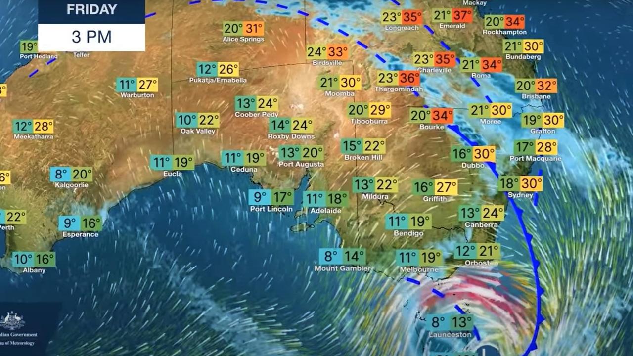
Hot in South Australia today with Adelaide topping out at 31C. Total fire bans are in place across the eastern Eyre Peninsula and Flinders Ranges.
As that low passes, the temperatures will drop to 27C on Thursday and then a steep fall to 17 to 18C heading into the weekend. Storms are possible on Wednesday and Thursday with up to 20mm of rain falling before the end of the week.
A high of 27C in Melbourne on Wednesday, but then it could get soggier in the city with up to 15mm falling before the weekend. Temperatures will gradually drop to 21C on Friday and just 16C on Saturday with a minimum of 8C on weekend mornings.
Thursday could see storms in Melbourne.
It’s pretty much the same conditions across the state with wet weather from Thursday onwards and into the weekend.
Tasmania will top out at 22C on Wednesday and then down to 20C on Thursday and just 13C on Friday. Friday will be wet with up to 20mm of rain falling.
Snow is a possibility on Kunanyi/Mount Wellington on Friday and Saturday as temperatures drop to -3C as well as peaks across the island.
Friday heat, humid and stormy in the east
The heat will come slightly later the further north you go. Canberra’s hottest day of the week will be Thursday with the mercury reaching 26C with 25C on Friday and chance of a storm. The weekend should be cooler with maximums in the high teens.
Sydney is set to swelter on Friday with the city now officially expected to hit at least 33C and the city’s west 34C. But some meteorologists have said 35C-plus is a distinct possibility. It will be humid too with moisture in the air.
The CBD will almost touch 30C on Thursday, before Friday’s peak, but by Saturday a more manageable 24C is forecast.
Possible rain from Friday onwards with a chance of a storm to ease into the weekend.
Western parts of NSW will feel the heat on Thursday while storms could spread up the coast towards the north east on Friday and Saturday.
Queensland has seen plenty of thunder and lightning recently including in the Sunshine Coast on Tuesday evening,
Brisbane is looking at 26C and some rain on Wednesday with temperatures gradually rising to a high of 33C on Saturday which could coincide with showers. Friday is the best chance for a storm but Saturday could also see some thunder and lightning.
Nights will be warm with temperatures getting down to around the 20C mark.
Northern parts of Queensland should be settled with 33C highs in Townsville and some showers on Sunday.

Storms in Perth on Wednesday with a high of 18C and up to 20mm of rain.
Then more settled conditions as the weather drama heads to the east. Expect a steady rise in temperatures to a Saturday maximum of 25C.
Stormy in the Top End too. Temperatures will top out at 35C most days with lows of 24C and a smattering of rain in Darwin.

‘Diabolical’: Fury as mansions swallowed up
A row of waterfront mansions are close to collapsing into the ocean as massive swell erodes the beach. One fed-up homeowner says it exposes a “diabolical” failure.

If you live here, work from home today
Millions of Aussies have been told to stay home and avoid travelling if necessary after a freak “cyclone bomb” sparked commuter chaos and led to services being cancelled.

Wild storm throws trains, buses into chaos
Train and bus routes across NSW have been thrown into chaos as a freak storm – equivalent to a category 1 cyclone – smashes the east coast of Australia.