
Extreme heatwave and high humidity as southeast set to swelter
If you think today is muggy, get ready for Friday when mud rain could fall and the “oppressive” humidity will lead southern states to feel like the Top End at its worst.

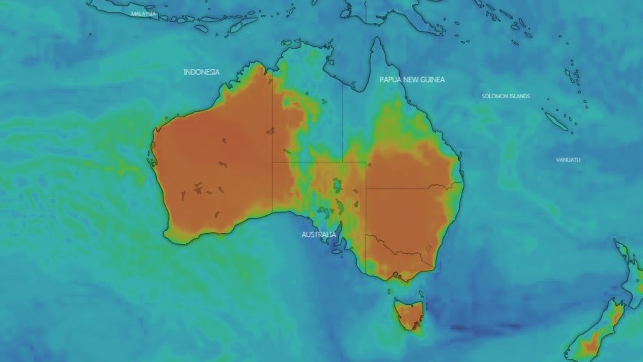
A “heat burst” is erupting across southern Australia which will send the mercury in three capitals north of 40C for several days, elevate fire dangers and even see “mud rain” fall from the sky.
It could be so hot and sticky tomorrow, Melbourne will feel more like Darwin during the build up, forecasters have warned. There’s as simple reason why – because the Northern Territory’s moisture is on a crash course with the south.
Adelaide CBD hit 40C this morning just before noon, Port Augusta is on 45C. Melbourne is at 38C at 3.30pm and both Canberra and Hobart have hit 35C.
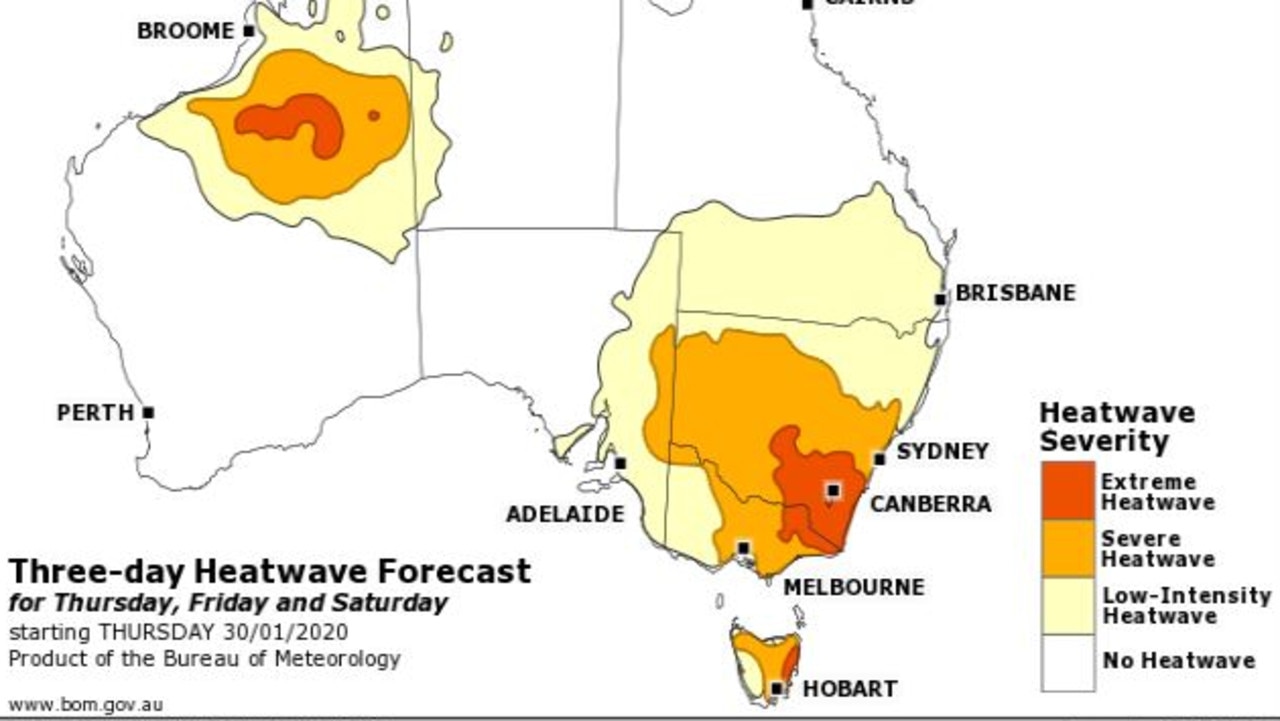
The Bureau of Meteorology has warned of a severe heatwave starting today across much of southeast Australia.
An extreme heatwave, the most intense type you can get, will engulf south eastern New South Wales, Canberra and parts of Tasmania. Extreme intensity heatwaves can have health impacts on even healthy people if they don’t find ways to remain cool.
The bureau has said it would be “uncomfortably hot today, unbearable tomorrow” for those used to Tasmanian temperatures. In Hobart, it could be 38C, that’s 16C above the normal January high of 22C in the coming days.
Melbourne is looking at two days close to or surpassing 40C, Canberra could hit 40C tomorrow and Saturday, and parts of Sydney will get to 45C on the weekend.
The Bureau of Meteorology’s Grace Legge said clear skies over Western Australia had led to a mass of hot air building up.
“It’s heading east peaking on Thursday for South Australia, it then moves into Victoria and Tasmania on Friday before heading into New South Wales and the ACT,” she said.
“A severe heatwave is developing through much of southern Australia with higher temperatures accompanied by warm nights due an increase in humidity following that initial burst of heat.”
Severe bushfire conditions have been declared for six South Australian districts as authorities brace for a day of soaring temperatures and rising winds.
The South Australian Country Fire Service says total fire bans have been declared for the lower Eyre Peninsula, the mid-north, the Mount Lofty Ranges, Yorke Peninsula, the lower southeast and on Kangaroo Island today.
Victoria emergency management commissioner Andrew Crisp warned Victorians of the weather ahead.
“Thursday will be warm, but Friday is a significant day for us with elevated fire conditions. There’ll be storms that come through with the potential for dry lightning, so again it’s a challenging day for us,” he said.
A total fire ban is in place from midnight tonight in Melbourne, the Mallee, Wimmera, south-west districts.
MELBOURNE MORE LIKE DARWIN
The humidity is going to be very high and it’s going to be widespread, Sky News Weather channel meteorologist Tom Saunders said.
“By Saturday morning we will have high humidity through southern and western parts of South Australia along with western Victoria,” he said.
All of Tasmania as well as coastal NSW and Queensland will swelter through the humidity with only inland areas and eastern Victoria escaping the worst.
Speaking this afternoon, Bureau Meteorologist said the conditions will be hot like today, but will feel worse.
“The increase in humidity is going to lead to really oppressive conditions, thanks to a tropical plunge moving across Victoria.
“It’s going feel, some parts, more like a build-up day in Darwin rather than what we’re accustomed to in Melbourne. Now, for Melbourne, the conditions are really gonna feel incredibly muggy,” she said.
Many places in the southeast won’t see temperatures dip lower than the mid-twenties for several days, even in the dead of night. That could lead to interrupted sleep and grumpy mornings.
Neither Melbourne nor Adelaide are likely to see a night lower than 20C until early Sunday. The ACT could have some very warm nights early on Saturday and Sunday while Sydney is not expected to dip below 20C until Tuesday.
New South Wales and southern Queensland in #Australia will be getting hotter again as we head through the week but there are signs of less warm air moving in from the south over the weekend #bushfire pic.twitter.com/9dOyrkgibz
— Met Office (@metoffice) January 29, 2020
Uncomfortably hot for Tasmania today, unbearable tomorrow. (If you are more used to typical Tassie temperatures.) Humid tomorrow night. See exactly what to expect at your place at https://t.co/89tUjpsH2x
— Bureau of Meteorology, Tasmania (@BOM_Tas) January 29, 2020
While we swelter in #heatwave conditions today, be mindful heavy rain is forecast later this week. A Flood Watch has been issued as heavy falls may cause flooding north on Thursday, tracking to central SA, Mt Lofty Ranges and SE Friday to Saturday. Details https://t.co/raJyVRHUUc pic.twitter.com/dIHSBUHyDP
— Bureau of Meteorology, South Australia (@BOM_SA) January 30, 2020
MUD RAIN
The Harbour City is looking at 31C in the CBD tomorrow and Sunday and 34C on Saturday, with the city’s west reaching a scorching 45C on Saturday.
Hobart will also feel the heat with a high of 33C today and 38 tomorrow before dropping to 28C on Saturday.
The stickiness is being caused by monsoonal rain band being gradually sucked south from the Top End. It will eventually bring showers that should hit South Australia tomorrow and Saturday, bringing as much as 50mm of rain. Victoria and Tasmania should see showers on Saturday but the humidity could remain.
It could almost biblical in Victoria with warnings of gusty winds, dust storms and mud rain.
Sydney could see storms towards the end of the weekend.
In the north of Australia, the monsoonal rains are still packing a punch with 60mm of rain falling on Townsville since yesterday. They are currently heading towards the Territory.
Darwin should see highs of up to 34C and afternoon storms. Expect 31C in Brisbane, but it will be mostly dry south of the monsoon.
It will be cooler in Perth now it has sent its heat east. It will be about 23C in the West Australian capital with a sunny weekend that could get as high as 34C on Sunday.
Join the conversation
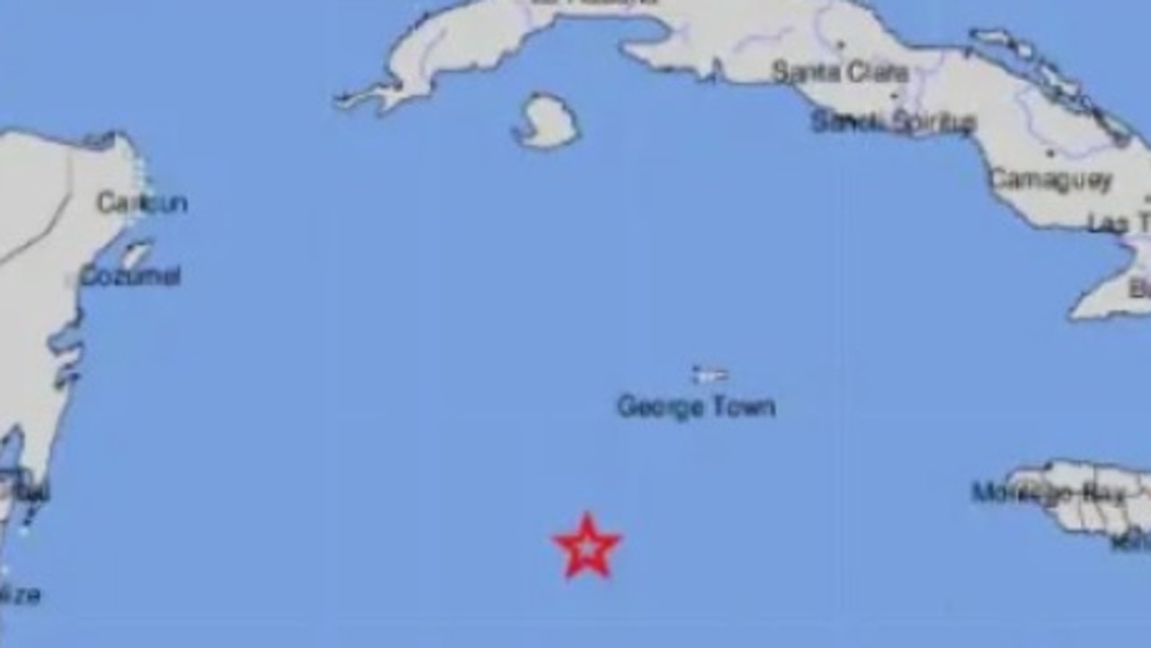
Tsunami warnings after massive quake
A magnitude 7.6 earthquake in the middle of the Caribbean Sea triggered a wave of tsunami warnings around the region.
Read more
Cyclone threat for Aussie tourist town
Residents have been warned to stay inside and secure their belongings as a tropical cyclone threatens to develop and smash the coast in the next 24-48 hours.
Read more
Top 10 Aussie beaches revealed
Move over Bronte and Byron Bay, Australia has a new best beach according to the national tourism council
Read more