
‘Extreme heat’ could see records tumble in Melbourne, Adelaide, NSW
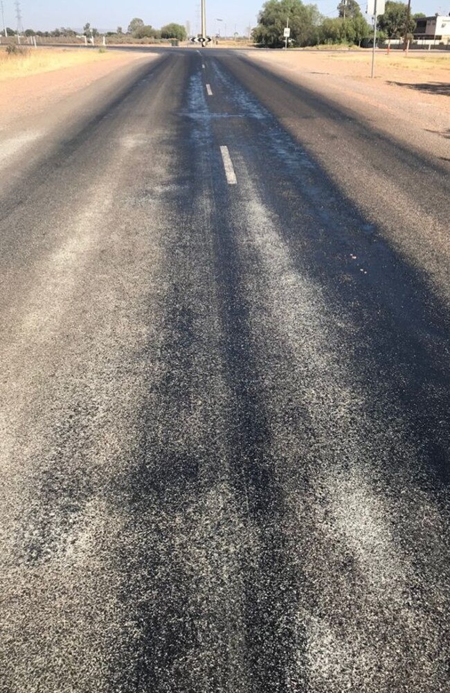
Roads in parts of South Australia are “bleeding” asphalt as the country swelters through one of its hottest ever days with four capitals seeing 40C+ temperatures.


Temperatures have reached such blistering highs in South Australia that roads have begun to melt.
The melting asphalt comes as the Bureau of Meteorology has issued a severe weather warning for Adelaide as a band of thunderstorms heads toward the city.
The CBD is set to hit 46C today. At 1pm the mercury had reached 43C.
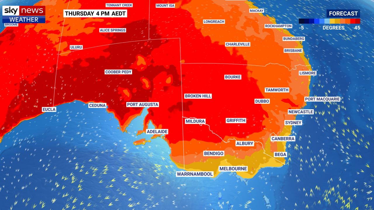
Australia’s record breaking heatwave continues across the south east. It’s possible that Australia could see its warmest ever day today, breaking a record that has been broken twice already just this week.
Wednesday’s average of 41.9C across the country was one degree hotter than the previous record set on Tuesday.
Melbourne could be about to see its hottest December day for 143 years today as temperatures climb as high as 44C on a day of “extreme heat”.
Sydney will get a break from the heat today. But it’s only a brief respite with temperatures set to soar on the weekend fanning massive fires that have encircled much of the city and led to the death of two firefighters.
In South Australia, Port Augusta is forecast to reach as high as 49C today. The Spencer Gulf town has sweltered through consecutive days of temperatures above 40C and now it seems the roads have given up the battle in the extreme heat.
In a Facebook post, Port Augusta Council said the road was “bleeding” and contractors would spread rocks across the melted areas.
One resident of nearby Port Pirie said it was so scorching petrol was “bubbling” out of the pump.
On Wednesday, when the mercury hit 45C, Katlyn Mitchell posted on social media to say she couldn’t believe what she was seeing.
“The fuel was bubbling. I asked the lady at the counter and she said it won’t be long before they will have to stop selling fuel as it’s boiling. Something I’ve never seen before,” she was reported as saying by The Advertiser.
The weather bureau has issued a severe thunderstorm warning for Adelaide, Murray Bridge, Whyalla and up to the Northern Territory border.
No rain is likely but gusty dry lightning could be accompanied by damaging winds of up to 90km/h.
The BOM has advised people stay indoors and avoid being close to trees.
A Severe Thunderstorm Warning has been issues for parts of #SouthAustralia including #Adelaide. Storms are developing in the west and north of the area and will track eastwards over the next few hours. Refer https://t.co/FhLhHeoTC9 pic.twitter.com/JMr7ZCtnXp
— Bureau of Meteorology, South Australia (@BOM_SA) December 20, 2019
Yesterday, Nullarbor in South Australia recorded a temperature of 49.9C. That’s the fourth highest temperature ever recorded in a single location in Australia and the highest ever December temperature. Adelaide’s CBD had its hottest night on record last night with the mercury bottoming out at a blistering 33.6C.
“Very hot northerly winds are pushing down into South Australia, inland NSW and Victoria,” said Sky Weather News channel Meteorologist Alison Osborne this morning.
“A cool change will come through South Australia in the afternoon which will see temperatures drop drastically but not before what promises to be a very trying day.”
Adelaide is completely surrounded by areas with catastrophic fire warnings in place – the most serious you can get.
Expect smoke haze and possible gusty dry lightning across the city. At 8.30am it was already 38C in the city.
Today’s high of 46C will sink by more than 20C overnight with a high of just 25C on Saturday and 29C on Sunday.
Over the border, the Bureau of Meteorology has said Victoria is looking at a day of “extreme heat”. The west of the state has extreme fire danger ratings and Melbourne has a severe warning in place.
Melbourne CBD is forecast to hit 44C on Friday. The last time it climbed that high in December was 1876.
Then a massive drop overnight to just 20C tomorrow and 22C on Sunday during a partly cloudy weekend.
Parts of Tasmania are set to reach temperatures about 16C above the state average on Friday – Hobart could see 33C. Like Victoria, a cool change will breeze through with a maximum of 23C on Saturday.
âš ï¸ Extreme heat is forecast for much of #Victoria today, with a statewide Total Fire Ban in place @CFA_Updates and heat health alerts current @VicGovDHHS Know your weather, know your risk. Latest warnings and observations at https://t.co/sTH01i9wLI #SurviveTheHeat
— Bureau of Meteorology, Victoria (@BOM_Vic) December 19, 2019
With the temperature expected to soar over 40 degrees today a TOTAL FIRE BAN has been declared across the state.
— MFB (@MFB_NEWS) December 19, 2019
For information about what you can and can't do on a Total Fire Ban day visit: https://t.co/zgl1rZaVsu pic.twitter.com/3s82tXhO6d
On Friday, NSW is a tale of two temperatures. West of the Great Dividing Range, the state is sharing in the pain of elsewhere. Tops of 40C in Bathurst, 42C in Tamworth, 44C in Wagga Wagga, 45C on Broken Hill.
But much cooler by the coast, Sydney will reach just 26C today with the city’s west a little hotter at 32C.
It won’t stay like that for long. The heat will crank up on the coast ahead of an approaching cold front later on Saturday. Sydney’s CBD will see 33C on Saturday but in the west it could get as high as 47C.
On Sunday, after the trough passes, the highs in the west will plummet by 20C to just 27C and 23C in the city.
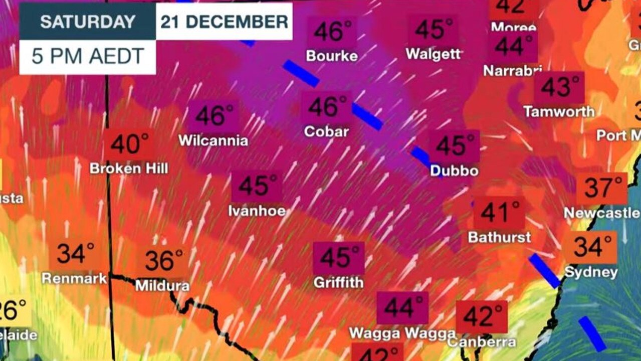
Inland NSW will see maximums in the forties on Saturday but there will be some relief on Sunday with highs in the low thirties.
There could some storms early next week in the north of the state but elsewhere rain looks unlikely.
A total fire ban is in place across NSW.
The 39.3C that sweltered through Canberra on Thursday to set the capital’s hottest December day might come a close second if the capital reaches the 41C forecast on Friday and Saturday.
Smoke is likely to continue to envelop the capital. Temperatures should drop into the twenties on Sunday before rising once again as we head into Christmas week.
Steady as she goes in Brisbane with highs around 33C for the weekend and into Christmas. Sunny skies and no rain.
In Townsville, 33C and sunny today and much of next week.
In Darwin, 35C and possible afternoon storms are forecast.
Perth, which has had its fair share of heat, is sitting this one out today. It will reach just 25C in the city on Friday, then a jump to 34C on Saturday before settling around the 30C mark into Christmas.
Women injured by lightning amid Anzac deluge
Two women have been injured in separate lightning strikes after one Aussie state was pounded by more than 200mm of rain over Anzac Day.

Millions facing long weekend washout
Long weekend plans could be under threat across swathes of the country as millions brace for heavy rain and thunderstorms.
Major city rocked by earthquake
People have rushed onto the streets after the city was hit by a 6.2 magnitude earthquake on Wednesday.