
Cold fronts crossing WA set to bring eastern states rain and gloom
WA’s southwest will cop some rain from Sunday evening, before a cold front moves east later in the week.
Millions of Australians are being warned to brace for wild weather as storms, strong winds and hail are set to hit most of the country this week, bringing the warm winter days to an end.
Western Australia will catch the brunt of the cold front, bringing chilly temperatures and rain, before the system moves over the eastern states later in the week.
The heavy rain will first lash the state’s south-west region as the cold front moves east over Sunday and Monday before hitting the east coast on Wednesday.
Rain is expected to hit most of the country for the next seven to 10 days.
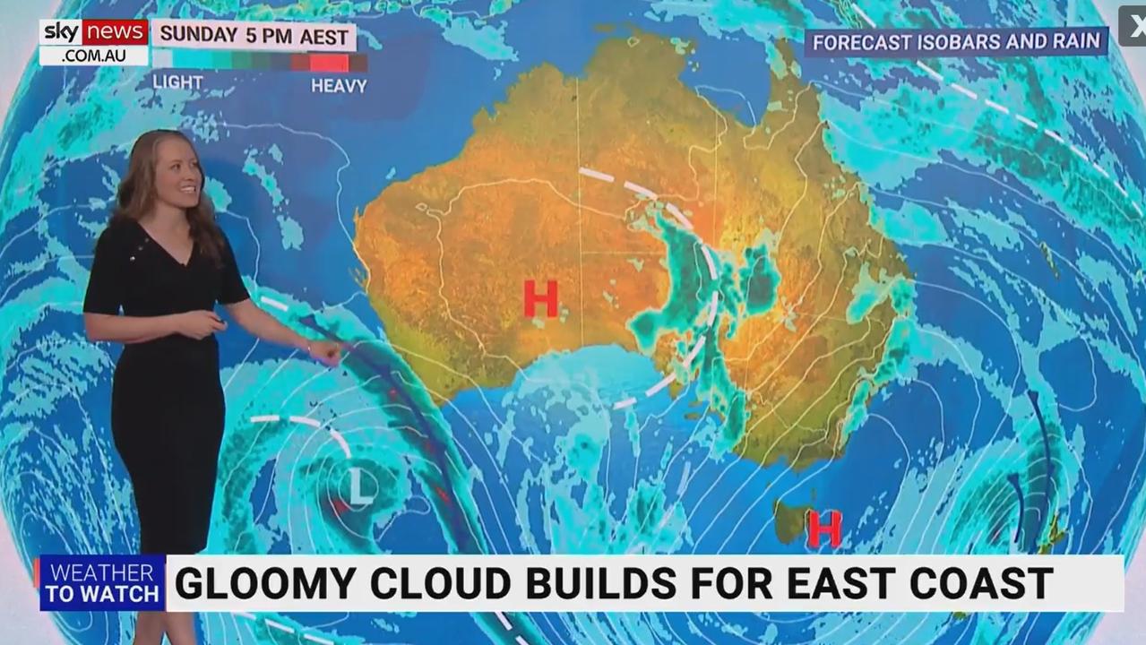
The upper-level trough will destabilise the atmosphere, making way for a second front to push through later on Monday, meaning some areas of WA could experience up to 48 hours of rainfall.
It follows a sudden deluge for Perth and surrounds on Wednesday, prompting severe weather warnings, and causing a few major roads to flood.
Conditions in the WA capital have been cool and sunny since, but change is on the way.
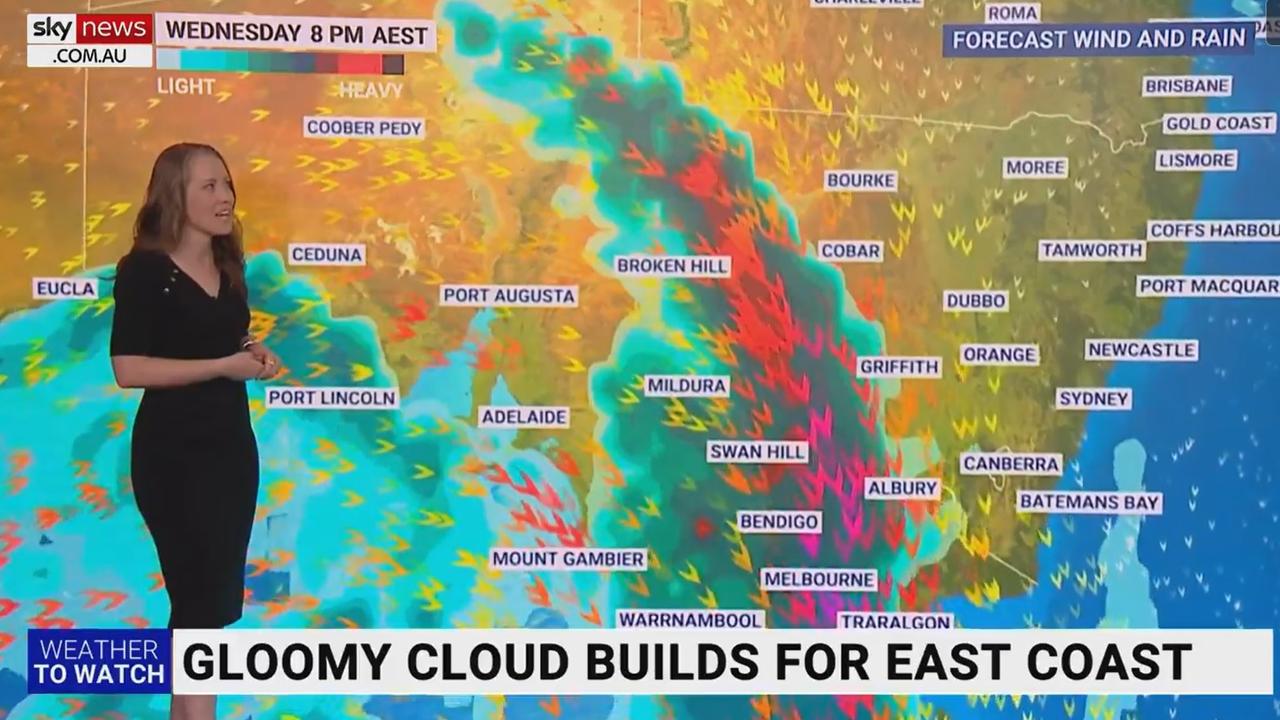
Meanwhile, eastern states have their own wet weather incoming from Monday.
“Onshore winds are driving in showers, while patchy rain fills the gauges through inland New South Wales, with a side of quite gusty northerly winds,” Sky Weather meteorologist Alison Osborne said.
“Into Tuesday, the wet weather briefly spreads towards the coast south of about Sydney, and then one of Western Australia’s cold fronts pushes on in.
“This is likely to be heavy, with some gusty wind sweeping through South Australia on Wednesday morning, Victoria and New South Wales on Wednesday night and into Thursday morning.”
However, Ms Osborne predicts this will make it far too warm for snow ahead of the ski resort opening weekend.
Weatherzone is also warning the mornings and nights will be “dangerously foggy”, as pockets of high humidity settle.
Parts of Sydney recorded their warmest Winter days since 2004 on Friday, with Mascot recording a temperature of 24.2C.
Gunnedah, in the north-east of NSW, recorded 24.7C on Friday - the highest June temperature in 69 years.
Wet weather will develop across south-east #Aus over the coming days with showers, isolated storms and rain areas.
— Bureau of Meteorology, Australia (@BOM_au) June 3, 2023
Mild conditions will become cooler by the end of next week.
Latest: https://t.co/4W35o8i7wJpic.twitter.com/DcKhht8bck
Here’s the breakdown of each capital city over the next few days:
PERTH
Cloudy with a very high chance of showers for Western Australia Day on Monday, and the chance of a storm, with a top of 18C.
Similar conditions and down to 15C on Tuesday, and staying cloudy with a chance of showers into the weekend, tops staying below 20C.
ADELAIDE
Partly cloudy on Monday with a medium chance of showers and a top of 19C.
Mostly sunny and 22C on Tuesday but the showers will be back on Wednesday, back down to 19C, staying cloudy with the chance of showers into the weekend.
DARWIN
The Top End missing all the rain activity, with a sunny 31C Monday, and it’s sunshine with tops about 32C right through the week.
MELBOURNE
Partly cloudy with some fog about Monday morning, a top of 19C. Cloudy with a medium chance of showers Tuesday, building to a very high chance Wednesday and Thursday, easing into the weekend, with top temperatures dropping to 15C from Friday.
BRISBANE
Cloudy with a very high chance of showers on Monday, a top of 22C, easing to the slight chance of a shower Tuesday through Thursday, clearing to sunshine from Friday — tops in the mid-20s throughout.
SYDNEY
Cloudy with the slight chance of a shower for the return to work Monday, a top of 19C.
Cloud cover building, with a medium chance of showers Tuesday, easing on Wednesday, but a high chance of showers on Thursday, clearing to sunshine into the weekend — tops hanging about the low 20s.
CANBERRA
Cloudy with a top of 15C on Monday, with a medium chance of later showers, building to a high chance Tuesday morning.
More showers Wednesday, building to a very high chance on Thursday, but easing to a slight chance on Friday — daily top temps about 15C.
More Coverage

HOBART
Mostly sunny with the chance of frost Monday morning, 15C the top, turning partly cloudy with a medium chance of showers and 17C Tuesday.
Similar conditions Wednesday, building to a high chance of showers Thursday, and easing over Friday and into the weekend.

Greens demand PM act on toxic bloom
As one Aussie state continues to suffer from a “disaster” algae bloom that is putting the future of the fisheries industry in crisis, the Greens have made a simple demand from Albo.

‘Mind boggles’: Big call to bring back old tax
A former Treasury boss says the axing of a controversial tax “still boggles the mind” amid calls for stronger action to protect the environment.

One thing missing to fix Aussie crisis
Australia is dragging the developed world in one key area, with an expert suggesting a solution to “get this right” and “break the “deadlock”.