
Climate driver shaking up weekend weather
A climate driver in the Southern Ocean will have a major effect on Australia’s weather over the coming days with some places freezing.

Aussies will be familiar with the sister climate drivers La Nina and El Nino, the former of which brought intense rainfall and record-breaking floods for three unrelenting years.
Soon set to make its mark, however, is a third climate system which could see blue skies a plenty but also freezing conditions.
The Southern Annular Mode (SAM) is a belt of westerly winds that blow between Antarctica and Australia through the Southern Ocean. It’s described by the Bureau of Meteorology (BOM) as one of the major climate drivers that influences rainfall and temperature in Australia.
Meteorologists say the system has just reached one of its strongest positive levels on record.
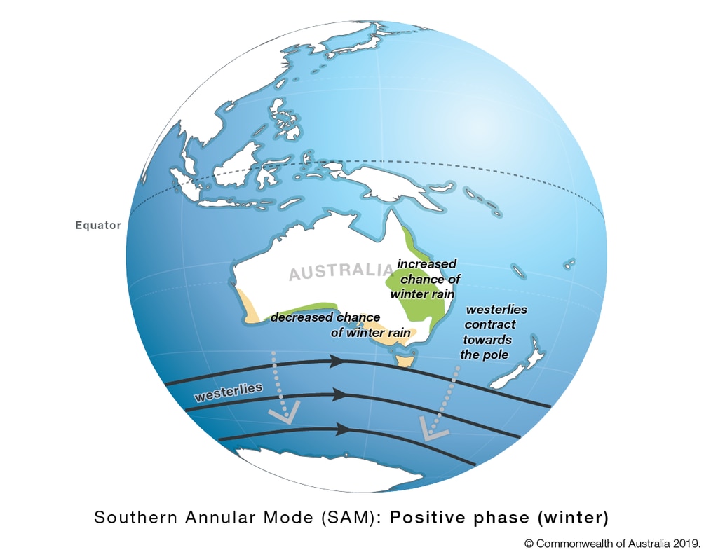
When the SAM is in a positive phase during winter, it tends to increase chances of winter rain in New South Wales and Queensland. While decreased winter rain are likely to set in over Victoria, Tasmania and parts of Western Australia.
The SAM’s exceptionally high positive level is leading to a relatively dry time for eastern Australia and clear skies.
Lunch in Perth today at C Restaurant. The sky is smoky from a bushfire or a controlled burn. pic.twitter.com/W1jYDtXmZ1
— Martin (@xodarapreturns) May 19, 2023
Bushfires in the west
Meanwhile in the west of the country, skies in Perth continue to be affected by a bushfire that burned earlier this week in nearby Whitby and Jarrahdale. The fire has since been contained but a heavy smoke haze remains over the capital.
Extreme fire danger is forecast for WA’s Burrup district, according to a warning from the BOM.
“Moderate to fresh and gusty easterly winds combined with warm and dry conditions will lead to elevated fire dangers again on Saturday,” the warning stated, urging affected residents to action their bushfire readiness plans and call triple-0 in cases of emergency.
The smoke haze over Perth is forecast to clear by noon on Saturday, opening up into sunny skies for the rest of the weekend. Showers are expected midweek.
Saturday will see a high of 23C and that will creep up to 25C by midweek.
Cooler conditions in the southeast
It will be cooler in the nation’s southeast, with freezing or below freezing temperatures expected in Canberra.
On the weekend, 13C highs will rise to 15C by midweek in Canberra. Overnight it will dip to 3C on Sunday and then -2C on Monday and -1C first thing Tuesday and Wednesday.
Sydneysiders can expect cool mornings with minimums of between 8 and 10C and then rising to 19C on the weekend and much the same for the rest of next week with little to no rain.
Showers in Melbourne on the weekend as well as late next week, and otherwise cloudy conditions. Minimum temperatures are expected to hover between 7C and 11C, with maximums of up to 18C.
Hobart will see maximums of around 13C on Saturday and Sunday rising to 17C on Monday and Tuesday. Lows will be about 7C and showers can be expected.


Seven consecutive days of rain are forecast for Adelaide although it should be relatively light. There will be minimums of between 9C and 11C and maximums of up to 19C. It will be coolest on Monday with 9C at dawn.
Brisbane will remain relatively sunny, without any rain forecast in the coming week and highs of up to 25C on Thursday but mostly around 22C with 10C lows.
Darwin, meanwhile, will see maximum temperatures sitting in the low thirties all week long.

Brutal winter blast sparks warnings
A savage winter blast is sweeping across the country, bringing gale-force winds, icy temperatures and widespread weather alerts.

States told to brace for weekend cold front
Windy weather has finally subsided across Australia’s southern regions, but a cold front is bearing down on these states for the weekend.

Fury as fire ants hit major coalmine
A fire ant outbreak has hit a coalmine in a major mining state, with environmentalists calling the discovery a “spectacular failure”.