
Australia’s autumn weather outlook: Wet conditions sent to linger until May
For much of Australia, summer has barely begun and now it’s over. If you were hoping for a change in autumn, you’ll be disappointed.

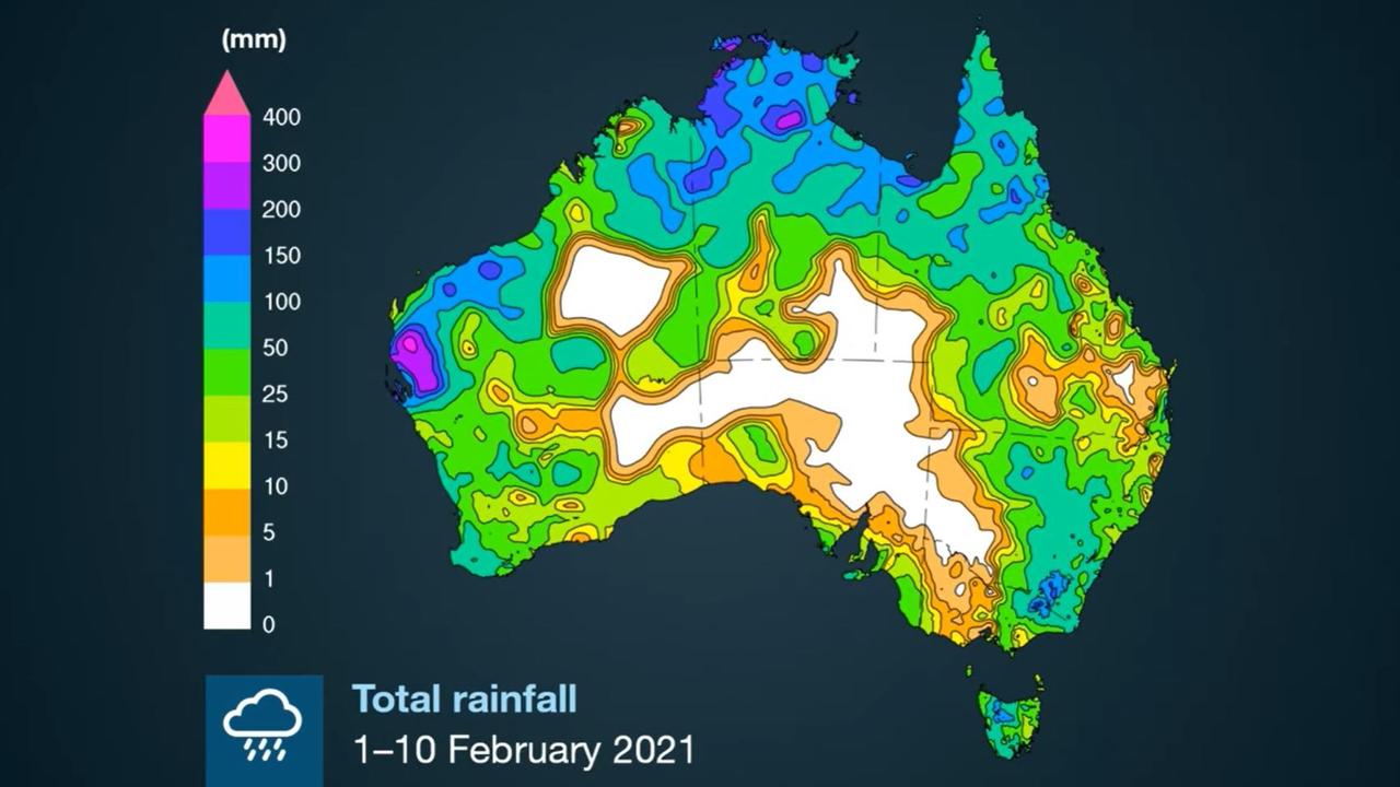
The defining feature of summer, particularly on the east coast, has been the rain, with La Nina lashing the continent.
Autumn begins on Monday, so you might be hoping for a change. Well, that’s not going to happen.
There could be glimpses of summer like weather in the upcoming season, but what’s more likely is more miserable and soggy conditions. That’s according to the Bureau of Meteorology’s (BOM) autumn weather outlook that’s just been released.
The La Nina climate driver has seen moisture pushed on to east coast states from the Pacific. That situation might not last for all that much longer though.
“La Nina is past its peak with the tropical Pacific likely to return to ENSO (El Nino Southern Oscillation) conditions during the autumn,” said BOM senior meteorologist Dr Andrew Watkins.
But it could take until May for La Nina to finally bid Australia adieu.
The upshot is above average rainfall across New South Wales, Queensland, parts of South Australia and eastern Tasmania in March and April and that lessening in May.
Most of Victoria, as well as Western Australia and the Northern Territory should see average rain.
RELATED: The weather forecast where you live

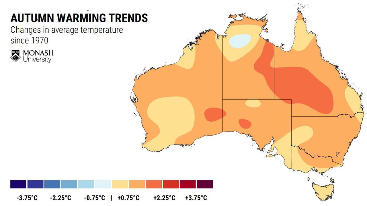
A HOTTER AUTUMN
It could be hotter this autumn with the mercury rising across Australia’s north, Tasmania, south west Western Australia around Perth and southern Victoria including Melbourne. That’s no change for WA which has seen runs of scorching temperatures this summer.
But parts of NSW close to Sydney and the ACT could actually see a slightly cooler than average autumn.
RELATED: UN calls out Aussie suburb for dire heat record
“La Nina can turn Australian climate on its head,” said Associate Professor David Holmes from the Monash University Climate Change Communications Hub.
“Of all the capital cities, Canberra has shown the strongest autumn daytime warming trend over the past 50 years and Hobart the weakest. However, the autumn outlook suggests Hobart is the capital city with the highest chance of warmer than normal days while Canberra has the highest odds of below average temperatures.
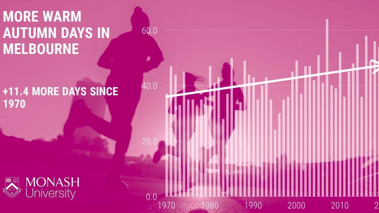
“Compared to averages for the past few decades, we’re seeing temperatures much closer to average in early 2021 because of La Nina – but this is a brief reprieve, and we can expect warming trends to continue into the future.
“Sixteen of the last 20 autumns have been warmer than average over Australia and this is largely a consequence of increasing greenhouse gases in our atmosphere.”
RELATED: Australia’s weird weather baffling scientists
Autumn minimum temperatures are likely to be higher than average across most of Australia except for parts of southern WA and western and central SA.
Chances of warmer nights are greater than 80 per cent for the northern tropics, eastern Queensland, southern Victoria, and Tasmania.
The wet summer may not have led to many beach days but it’s been blessing in other ways.
The seasonal bushfire risk is below normal for northern Queensland and southern and eastern Victoria.
The only place where the bushfire risk has increased above the average is in some areas of central coastal Queensland.
All that water has also helped top up Australia’s water shortages. Most are in a healthier condition than this time last year with big increases in NSW.

‘Never seen before’: Shock pics of algal bloom
A federal minister has spoken out about the dead marine life from a toxic algal bloom as new pictures reveal the extent of the devastation.

Albo reconnects with Aussie icon in China
Anthony Albanese has gotten a big dose of panda diplomacy in China, reconnecting with an Aussie favourite as he winds down his state visit.

Greens demand PM act on toxic bloom
As one Aussie state continues to suffer from a “disaster” algae bloom that is putting the future of the fisheries industry in crisis, the Greens have made a simple demand from Albo.