Sydney to be smashed by huge storm
Sydney residents have been warned to swiftly batten down the hatches in preparation for the imminent arrival of a dangerous weather system.

Sydney residents have been warned to swiftly batten down the hatches in preparation for the imminent arrival of a dangerous weather system.
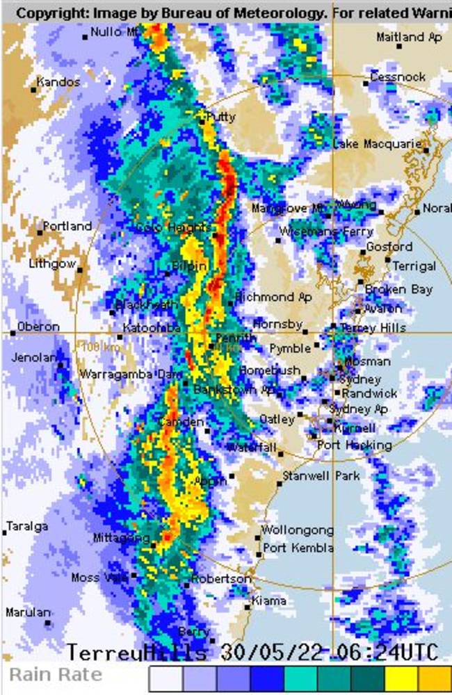
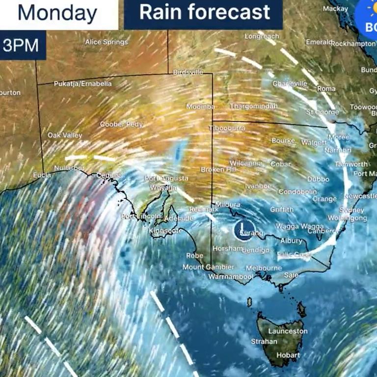
A lashing of powerful wind and heavy rainfall is set to smash the city on Monday afternoon, with severe weather warnings in place for the entirely of the NSW coastline.
Showers and thunderstorms were expected to hit the city by the evening, with damaging wind gusts in excess of 90 km/h possible over western and central NSW.
The Bureau of Meteorology said damaging winds averaging 70km/h with peak gusts reaching up to 100 to 110km/h were likely on and east of the Great Dividing Range, particularly at higher ground, from Monday evening onwards, continuing through Tuesday.
Locations expected to be affected included Grafton, Coffs Harbour, Port Macquarie, Taree, Newcastle, Gosford, Sydney, Wollongong, Nowra, Batemans Bay, Armidale, Orange, Canberra, Goulburn, Tamworth, Dubbo, Wagga Wagga, Albury, Deniliquin, Cobar and Broken Hill.
The State Emergency Service advised residents to move their vehicles under cover and away from trees, secure or put away loose items around the house, yard and balcony, and keep at least eight metres away from fallen power lines or objects that may be energised.
The SES said it was important to “stay vigilant and monitor conditions”.
Stream more weather news live & on demand with Flash. 25+ news channels in 1 place. New to Flash? Try 1 month free. Offer ends 31 October, 2022 >
A strong cold front moving east is bringing the chance of damaging winds to much of the state, a #SevereWeatherWarning is current. Take care on roads, fallen trees are possible in saturated soils.
— Bureau of Meteorology, New South Wales (@BOM_NSW) May 30, 2022
Check forecasts: https://t.co/Qm4EFazRWl
Monitor warnings: https://t.co/PY5TDraQKspic.twitter.com/f0AyJ579eI

Queenslanders were also warned to prepare for a severe weather event Monday evening, with the BOM issuing a severe weather warning for damaging winds in the state’s southeast.
The bureau said gusts exceeding 90kph were possible, and warned locals to keep a safe distance from trees and powerlines given recent rain had saturated the soil.
The worst of the wind was expected to linger across the southeast befor smashing Brisbane, the Gold Coast, and Sunshine Coast in the morning.
Freezing week ahead
South Australia, Victoria, Tasmania and NSW are in for a week of freezing, winter weather, thanks to a cold front that’s set to blast Australia’s southeast.
Damaging winds, plunging temperatures, rain and even snow was forecasted from Sunday onwards, with the Bureau of Meteorology in Victoria threatening a “blast of winter”.
“Much of southern and eastern Australia will be impacted by a strong cold front and low-pressure system from Sunday and into next week,” a release from BOM read.
“Residents of southeast SA, Vic, Tas and eastern NSW to feel the brunt of the weather systems with below-average temperatures, showers, low-level snow and brisk winds.”
When the coldest weather will hit
According to Sky News Meteorologist, Rob Sharpe, moisture from a weather system coming in from the north west of Western Australia is joining a strong cold front and major low pressure system that’s coming up from South Australia, resulting in significant rain totals and snow.
NSW will be hit with the iciest temperatures by Wednesday, as “the Antarctic blast will have really taken shape through the south east,” he said.
“It is exceptionally cold today and this event will be remarkable for South Australia and NSW but right across the south east. It is going to be cold, wet and windy in many locations,” Mr Sharpe continued.

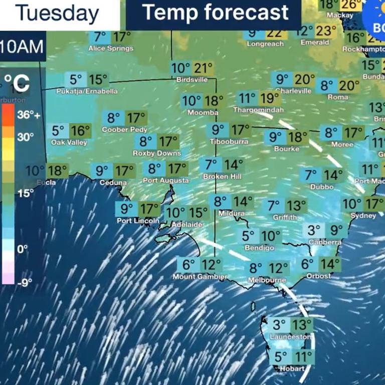
Temperatures are likely to remain around 3C to 6C below averages into the rest of next week. The strong winds are likely to “make conditions feel much colder during the day,” states the BOM.
While much of the cold front will lash coastal areas, inland locations as far south as southern Queensland and the Northern Territory will also feel the icy sting.
Adelaide residents are in for a low of 10C and highs of 15C on Tuesday. In Melbourne, the temperature is even lower with a forecast of 8C to 12C.
“Gusty winds with showers and storms across the north tonight and tomorrow. Small hail and possible snow down to 700m on Tuesday.

Several states hit with damaging winds
Damaging winds will also be a concern from now to late Wednesday. The gusts will also make the winter weather feel colder than it actually is.
A large severe weather warning has been issued for large areas of South Australia, Victoria, the ACT, NSW and the south east coast of Western Australia, from Esperance to Eucia along the border.
Winter is on the way with windy conditions developing across #NSWweather today and continuing for a few days. Colder temperatures on the way too with snow possible along the ranges. Warning current for damaging winds. Full details https://t.co/1yxAIPrpyJpic.twitter.com/KEiboj6RL4
— Bureau of Meteorology, New South Wales (@BOM_NSW) May 29, 2022
In Adelaide, heavy rainfall and damaging winds are forecast for the Adelaide Metropolitan and Mount Lofty Ranges districts. A Sheep Graziers Warning and a Coastal Wind Warning has also been issued for Victorians in the state’s north, with almost all of NSW issued with a warning for damaging winds.
The BOM have advised people to “continue to monitor warnings” as the severe weather warning evolve throughout the week.
“The cold front will reach the east coast late Monday and into Tuesday morning, with very strong northwest winds ahead that may generate damage along the NSW and southeast Qld coasts,” the BOM reports.
“These strong to damaging winds will continue — and peak — into Tuesday morning, and there are likely impacts for populated areas along the NSW and Qld coasts. These gusty winds will ease late Wednesday.”
âš ï¸Severe Weather Warning ongoing for #NSWweather. Damaging winds expected in the west of the state this morning, extending to the coast by this evening. Full details https://t.co/Ss766eSCrLpic.twitter.com/MtWeC84BuV
— Bureau of Meteorology, New South Wales (@BOM_NSW) May 29, 2022
The winter weather is also forecast to bring snow, to areas as low as 1100m to 1200m on Tuesday. The BOM predicts snow could fall to 800m across the NSW Central Tablelands and 600m for southeast NSW, Tasmania and Victoria.
The severe winds could also lead to possible blizzard conditions. The snow could even fall outside of alpine regions and even along the low mountain Dandenong Ranges. Alpine areas could receive “significant snow” accumulations of 20-50cm.


