
Antarctic oscillation brings a record breaking run of hot weather as capitals break 30C
THIS week, nearly every capital will see highs of 30C or more as the summer-like conditions continue. It’s not stopping then, either.


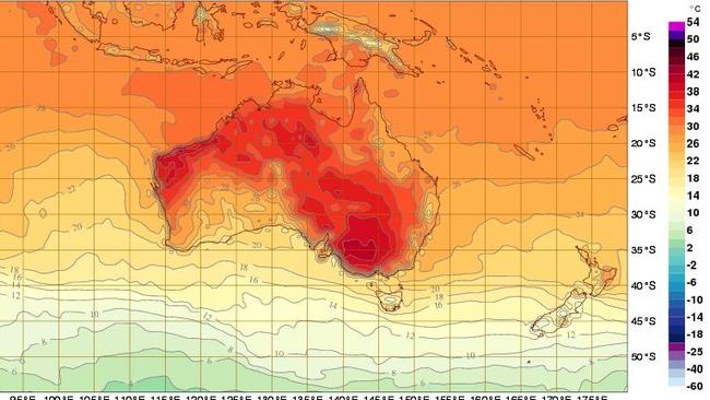
IT’S all SAM’s fault. This seemingly never-ending run of sweaty days and sticky nights culminating today in tops of 33C in Canberra, 34C in Perth, 35C in Melbourne and a tinder dry high of 36C in Adelaide.
Well, it’s not all SAM’s fault but SAM must take a huge chunk of the blame.
What is SAM, you say? It’s the Southern Annular Mode. A fancy term for the wild and biting winds that shoot around Antarctica. Currently in a positive phase, it’s left us to bask in a record breaking run of hot, clammy days.
And it’s been some record. In Sydney, the city has now sweltered through 32 days straight of highs above 26C, breaking — by some margin — the previous record of 19 days in a row which occurred in 2014. It’s not much better at night either with only two nights in February dipping below 19C. Sydney has already had two heatwaves in 2016.
“It’s a scorcher,” Bureau of Meteorology (BoM) climatologist Kevin Smith told news.com.au. “A lot of people are now saying Autumn won’t start until April.”
There was a “70 to 75 per cent” chance of above average temperatures for the whole of March, he said.
Today’s 35C day in Melbourne is likely to be the highest this week with storms rolling through the city tomorrow, bringing rain. Nevertheless, temperatures are likely to continue to hover between 26C and 32C for several days.
To South Australians that might seem like heaven, with the mercury unlikely to fall below 32C all week. Similarly, Brisbane and the Gold Coast will stay around 30C or higher.
Residents of Perth can expect even hotter conditions tomorrow rising to 36C and settling around 32C towards the end of the week.
“We have some big highs sitting down below us that are very slow moving with a lot of northerly winds drawing dry heat from the middle of Australia to the coasts and that’s likely to last until at least Sunday,” said Mr Smith.
However, we need to be careful about getting too worked up about a dry spell.
“Summer is our warmest season and therefore the one when high temperature records are most likely to fall,” said the BoM’s Senior Climatologist, Agata Imielska and Blair Trewin in a piece for The Conversation.
“But what is most notable is the total lack of intervening cool conditions.”
Or in other words, there’s been no respite from the warm weather, no cool front to calm every one down, and — in NSW at least — few spots of rain to help the garden. It’s just been one long run of hot and humid conditions.
This is where SAM comes in, also known as the Antarctic Oscillation.
“It’s quite an interesting phenomenon and we don’t totally understand it.” said Mr Smith.
“The SAM spins the westerly winds around the Antarctic. In a positive phase, the winds are drawn closer to the Antarctic and away from southern coast of Australia meaning we’re not getting the rainfall we’d expect. In the negative phase the effect slows down so we get more frontal systems and more rainfall.
“Normally we have a negative phase during summer but things have changed and the SAM’s positive phase has continued into summer and that’s forecast to last for a couple of weeks.”
SAM is only part of the story. We mustn’t forget El Niño, the phenomenon caused by warmer sea temperatures in the Pacific sucking warm, moist air over North America while leaving Australia hot and dry.
The current El Niño has developed into the most significant and largest for nearly two decades, ranking alongside those in 1997-98 and 1982-83.
There are other factors too. “It is clear that climate change is playing its role here as well,” said Ms Imielska and Mr Trewin.
“Both land and ocean temperatures have warmed. And those warmer offshore sea surface temperatures keep our nights warmer, particularly in coastal cities.”
If you like beach weather rejoice, — if not despair — for the hot weather looks set to stick around for some time. According to the BoM’s climate outlook for Autumn, temperatures will remain stubbornly above average both during the day and night throughout March and possibly even longer.
But if it’s all this hot weather is getting to much, may we suggest a trip to Tasmania. This week Hobart will struggle to get above 25C with a brisk low of just 11C on Thursday night. Now that’s what we call Autumn.

‘Doomsday glacier’ could swallow cities
The collapse of this one glacier could raise sea levels enough to swallow cities all over the world.

Brutal winter blast sparks warnings
A savage winter blast is sweeping across the country, bringing gale-force winds, icy temperatures and widespread weather alerts.

States told to brace for weekend cold front
Windy weather has finally subsided across Australia’s southern regions, but a cold front is bearing down on these states for the weekend.