
‘It’s moving’: Wild weather danger shifts after 200mm of rain falls in parts of NSW
A weather system that dumped more than 200mm on parts of NSW, and saw the SES swamped with 1600 calls, isn’t done with Australia’s east just yet.
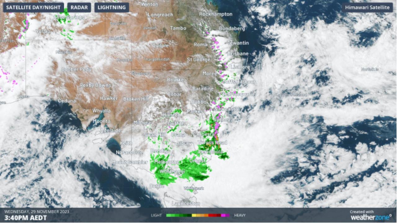
The State Emergency Service has responded to more than 1500 calls for help in the space of 24 hours as a 1500km storm band sweeps across Australia’s southeast.
Forecasters have warned that the wild conditions that saw as much as 200mm of rainfall in just 24 hours are not over yet.
At least another 100mm could fall in some areas before the current rain event subsides.
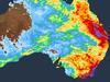
Weatherzone has warned a “broad arc” of dangerous thunderstorms was moving over Ausrtalia’s east, prompting severe storm warnings from central Queensland to southern NSW overnight.
“The problem is it could all come at once with severe thunderstorms,” said Bureau of Meteorology meteorologist Angus Hines.
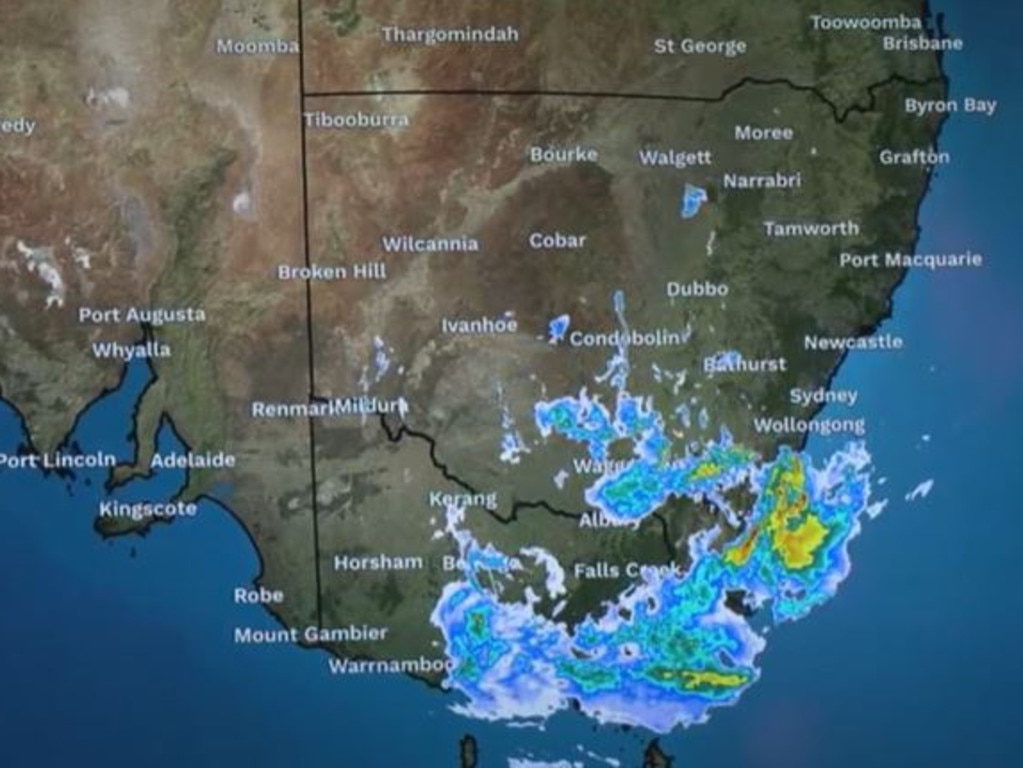
The danger area is south east New South Wales and eastern Victoria where flash flooding is a possibility on Thursday.
Conditions should ease by Friday, but even when the rain clouds move away so much moisture has fallen that rivers could burst their banks over the coming days.
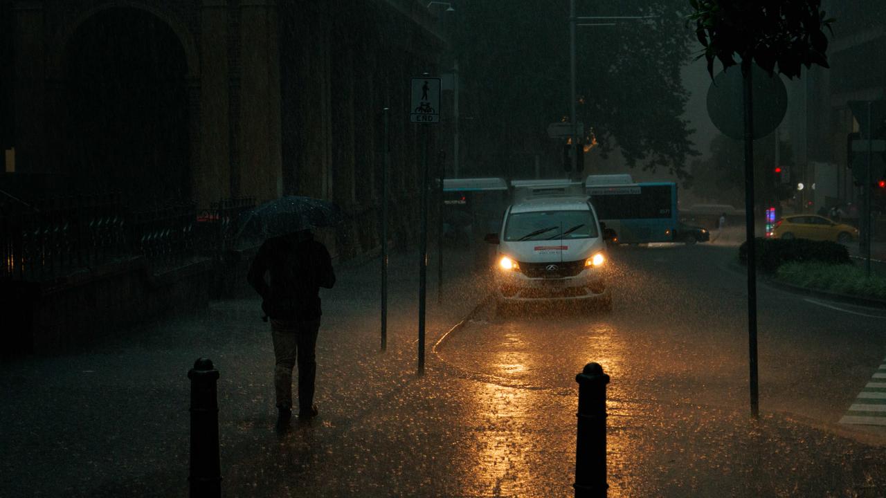
The NSW State Emergency Service (SES) said it received 1601 calls in the 24 hours to 5am on Thursday as a multitude of storms hit Sydney and the state as a whole including dangerous super cell storms.
In just two hours on Wednesday, 30mm fell on Sydney. That’s nothing compared to the state’s south east where record rainfall bucketed it down on some towns.
Bega saw 102mm and in isolated parts there was 200mm or more.
The Bega River peaked at 6.35 meters on Wednesday evening and it could rise again following Thursday’s rain, locals have been warned.
1600 calls to SES in 24 hours
“The NSW SES will keep pre-positioned flood rescue experts, high clearance vehicles and other rescue equipment in the south east and metropolitan Sydney on Thursday,” the organisation said in a statement.
“A low-pressure system sitting off the southern NSW coast is being supported by a second low further west, and is expected to bring further heavy rainfall and strong winds along the south coast this morning.”
The SES urged motorists to be careful on flood prone roads and never drive through flood waters.
Rain is set to continue across the state’s south east in places like Bega and Ulladulla on Thursday with potential storms.
The Bureau of Meteorology has a severe weather warning in place from Narooma to the Victorian border.
Moisture is expected to be pushed back from the sea to land on Thursday, the BOM warned, with rainfall totals of 60-100mm and isolated falls of 150mm. Winds could peak at 90km/h. Hazardous surf and fishing conditions are expected.
Sydney could still see some precipitation – up to around 6mm with the possibility of a thunderstorm – but it will be a lot calmer than Wednesday. The further you get from the state’s south east the drier it should be.
Canberra is forecast to get 10mm of rain on Thursday which some showers continuing into the weekend.

‘Shift in warnings’
“Everything’s moving southwards and that’s where we’ve seen a shift in our warnings” said the BOM’s Mr Hines.
“There will be further heavy rain and damaging winds around the south coast of NSW as well as a number of regions in the south and south east of Victoria where the wind and rain is anticipated to continue into tomorrow.
“There will be a response from the river network with flood watches now covering almost all the eastern rivers of Victoria and south eastern parts of NSW,” he said.
A severe weather warning is current in parts of Victoria’s Gippsland and north east regions. The danger will increase through Thursday with peak six-hourly totals of 40 to 80mm of rain likely with isolated falls up to 100mm.
Areas such as Mallacoota, Dargo and Mt Baw could be worst hit.
Melbourne will escape the worst with up to 3mm or rain on Thursday and 5mm on Friday and Saturday.

Much of Tasmania could see rain over the coming days but it’s unlikely to be heavy.
Brisbane should be dry on Thursday but showers could return on Friday and into the weekend. There are a number of flood warnings in Queensland after the recent rain. The Moonie River has a major flood warning in place around Thallon on the border with NSW.
Other states should be relatively dry, away from the weather drama of Australia’s east.

Millions brace for brutal cold fronts
A fresh wave of wild weather is preparing to lash Australia, bringing freezing winds, thunderstorms and icy blasts to millions.

Wild weather warning for this capital city
There will be “one last sting in the tail” of the polar air blast that has marched across Australia, with wild winds to continue battering the nation.

‘Lost everything’: ‘Bomb cyclone’ no fizzer
Just because you weren’t affected didn’t mean the “bomb cyclone” weather event was overhyped. Not everyone was so lucky.