
Sydney has been hit by flash floods as a month’s worth of rain falls on the city
Parts of Sydney are flooded after a month’s worth of rain continues to wreak havoc across the city.

A severe weather warning has been issued for Sydney as torrential rain wreaked havoc across the city this morning.
Roads and parks have been flooded, with some areas receiving more than a month’s rain in 24 hours.
Main roads such as Syd Einfeld Drive in Bondi and the Grand Parade in Ramsgate Beach are flooded causing traffic issues in the area.
Bureau of Meteorology forecaster Zhi-weng Chua said the heavy rain that passed over the city this morning will continue into the night but is predicted to ease later this afternoon as it shifts towards the South Coast.
“There has been consistent rainfall since this morning with 70mm falling since 9am and 102mm since 12am last night,” he said.
The monthly average for March is 149.9mm.

According to the forecaster “the highest rainfall received in the last 24 hours to 9am Sunday has been at Wyoming with 134.5mm,” the ABC reports.
“We’ve had now two flood rescues, one at Wyong and one at Gosford this morning and both involved cars attempting to drive across flooded roadways.”
#Showers, possibly heavy for central parts this morning - focus on #CentralCoast at the moment. If you are keen to know how much rain has been falling in #Sydney overnight, check out the rainfall from 9am at https://t.co/FkUkIT8A6I. Note: Avalon rain gauge has been playing up. pic.twitter.com/um4fAyHB7o
— Bureau of Meteorology, New South Wales (@BOM_NSW) March 16, 2019
Mr Chua said we can still expect light showers to continue over the next few days.
The severe weather warning is expected to be lifted this afternoon.
Warnings have been issued across the country as severe weather has been forecasted for the Western region, Victoria, Queensland and the Northern Territory.
WESTERN REGION
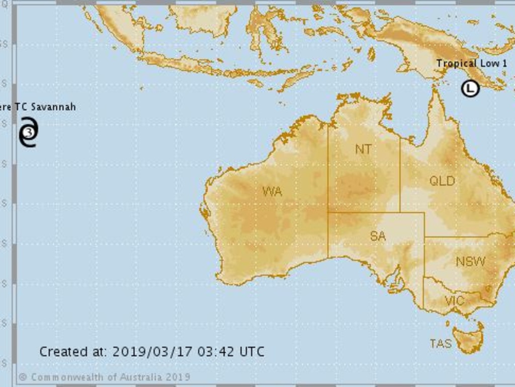
Existing tropical cyclone Savannah is forecast to keep moving west southwest taking it further away from the Cocos Islands.
It is likely to remain a tropical cyclone for at least the next few days.
VICTORIA
According to the Bureau of Meteorology, the focus of heavy rain will tomorrow shift south along the coast into far East Gippsland in Victoria before easing.
QUEENSLAND
The tropical low is expected to continue tracking in a general westwards directions towards the far north Queensland coast over the next couple of days. At this stage, the system is rated a high chance of forming into a tropical cyclone on Monday and is forecast to reach category 2 intensity prior to moving onto the far north Queensland coast late on Tuesday or Wednesday.
As the cyclone crosses the coast late on Tuesday or Wednesday, abnormally high tides are expected about the far north Queensland coast. Large waves are likely along the beachfront.

Heavy rainfall, which may lead to flash flooding, is forecast to develop across far north Queensland over the next few days.
The Bureau of Meteorology forecast more thunderstorms for the northeast and southeast of Queensland, including Brisbane extending inland with some of these storms likely to be severe, with heavy rain, large hail and damaging winds.
NORTHERN TERRITORY
The Bureau of Meteorology Northern Territory has issued a cyclone warning as a monsoon trough persists in the Timor and Arafura Seas.
A strengthening tropical low currently lies to the east of Papua New Guinea. This low is expected to track southwest into the Coral Sea over coming days. From Tuesday there is an increasing risk that the low may move west into the Gulf of Carpentaria.
It is predicted another low could potentially form in the Timor Sea or Indian Ocean today, though it is expected to track to the west or southwest and stay well outside of the Northern Region.
— with AAP

Man creeps into 7yo’s bedroom, rapes her
A man has been found guilty after he broke into a Perth home and sexually assaulted a seven-year-old girl who was asleep in her bedroom.

NRL star charged with threatening police
Canberra Raiders veteran player Josh Papalii has been charged over an ugly confrontation with police inside a licensed venue, just weeks before he won a prestigious award.

TV host announces her own tragic death
A beloved Australian TV host has announced her own death on social media after she lost her battle with motor neurone disease.