
Coroner hits out at police use of Google Maps printouts in search for missing man
Police said they’d searched bushland where a man mysteriously vanished. But 18 agonising months later, he was found in the same spot.


After Darrell Simon set off on his usual morning bike ride from his partner’s bushland home in November 2014, there was an excruciating wait for answers which lasted more than 18 months.
It was a time when those close to the 46-year-old from Laidley, between Brisbane and Toowoomba, just wanted to know what happened to him.
Instead some of those who knew him were subject to hurtful and defamatory speculation as the hunt for his body lingered on for 18 months.
To add insult to injury, his body was eventually discovered in an area police had marked down as “searched”.
According to a new coroner’s report into his death, the disappearance out of character and led police and his family to believe he had met with foul play — perhaps due to his financial problems.
But, this was not the case.
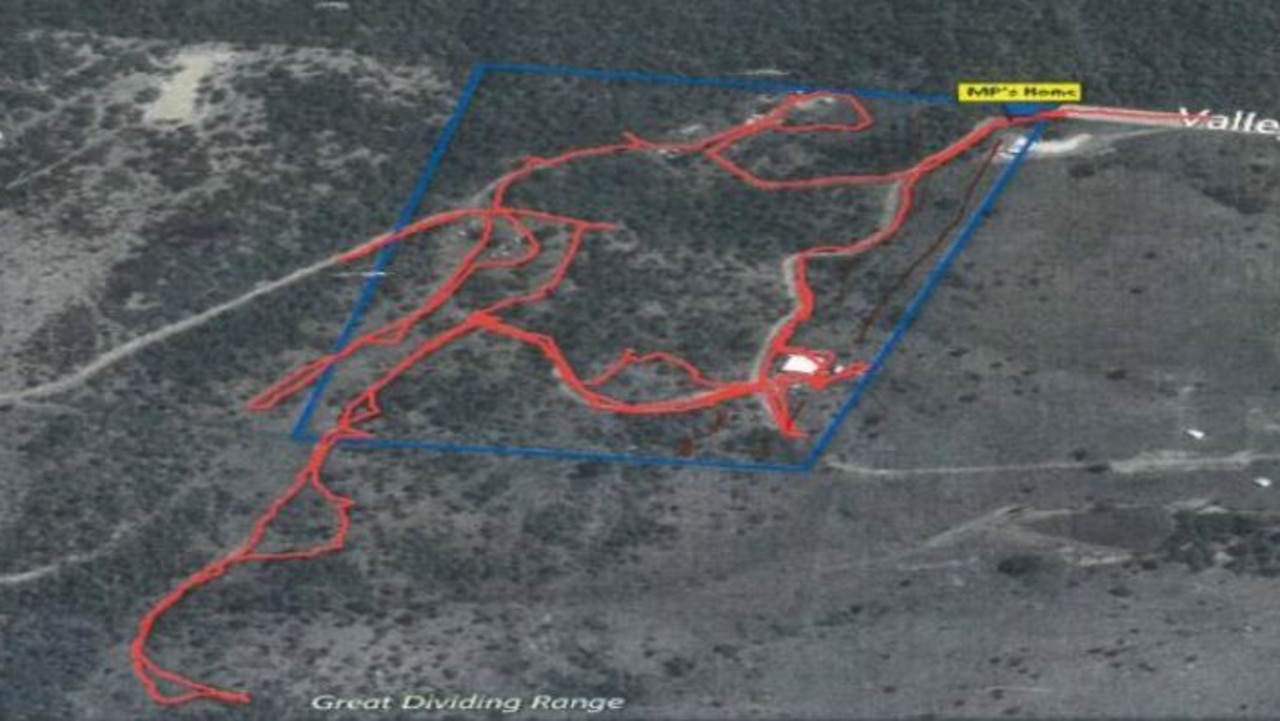
About a week after he vanished, police carried out a search 20km from his girlfriend’s house where he was last seen.
The searchers were given a printed copy of a Google Maps image to find the body. But the paper printouts didn’t show the property boundary and, as a result, only half of the block was searched by State Emergency Service crews.
They found nothing and it was not until a year later, when water levels in the dense bushland dropped and exposed Mr Simon’s mountain bike in a dam, that the search began again.
And it was still another three months after that, on May 21, that property owners found his remains beneath a tree, 70m from the dam.

The coroner hit out at the decision to rely on Google Maps printouts in the manhunt — noting that Queensland Police Service (QPS) had better tools available to them to search the area.
In fact, the inquest detailed how officers on the case were later given a much more informative aerial map of the area from the local council, at no cost to police whatsoever.
“It is quite apparent the quality of the images of the property on this map is far superior to the Google map images used in the search of the property and one wonders if the same mistake in conducting a search of only half the property would have been made if this map
had been obtained,” Deputy State Coroner John Lock said in his report.
The coroner was critical of how this affected those who knew Mr Simon — who was found to have taken his own life due to financial stress.
However, the coroner said the fact that Mr Simon’s remains had been missing for so long had fed speculation.
Mr Simon’s father, Lawrence Simon — who remained very involved in the search for his missing son and in advocating for him to be found — believed his son’s death may be suspicious and that he may have been harmed by someone else, possibly in a dispute over money.
“One wonders if Darrell’s body was found during the first police search on 23 November 2014, whether such unhelpful and at times clearly defamatory and untruthful speculation would have even surfaced,” the coroners report read.
“The fact the ground search was conducted over only half the property was very regretful and should not have happened.”
He recommended QPS officers be given further training and resources to allow them to properly co-ordinate and conduct land searches — meaning police will be forced to use high-resolution mapping and GPS systems in future searches.
He said there should also be improvements in communication with the SES to ensure accuracy.
“(I recommend) that QPS considers the adequacy of resources, information and training currently provided to its officers for the purpose of co-ordinating and conducting land searches to ensure officers are able to and do in fact access high-quality map products and GPS tracking data in a timely way.
“While not prescribing how QPS might ensure officers take these steps in the future, an example may be to implement some type of quality assurance checklist that officers are required to complete as they go.”
Police have advised the coroner it is taking steps to improve its procedures.
QPS has already implemented a mandatory “task sheet system” for every search and integrated search training between police officers and SES volunteers.
If you or anyone you know needs help, call Lifeline on 13 11 14.

AFL star’s heartbreaking apology at funeral
Friends and family of AFL star Troy Selwood have gathered to pay tribute to the beloved player and dad at an emotional service.
‘No right’: Sister’s anguish over girl’s death
She spoke ahead of the sentencing for the members of a cult-like religious circle after they were found guilty of manslaughter.
Update in mum’s mystery disappearance
CCTV footage shows Tayla Spies just hours before she vanished from a small town in Queensland’s Western Downs region in early February.