
Moment rower on daring 12,000 solo venture rescued from cyclonic seas off Aussie coast
Wild pictures have captured the moment a rower on a daring 12,000km solo venture was rescued from the rough seas of Tropical Cyclone Alfred.

A rower embarking on a daring 12,000km solo venture crossing the Pacific Ocean has been rescued off the Australian coast after being caught in Tropical Cyclone Alfred’s 130km/h winds.
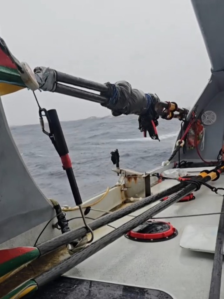
Lithuanian national Aurimas Mockus was 740km off the coast of Mackay in Central Queensland, attempting to cross the ocean between San Diego and Brisbane, when he ran into trouble on Friday night.
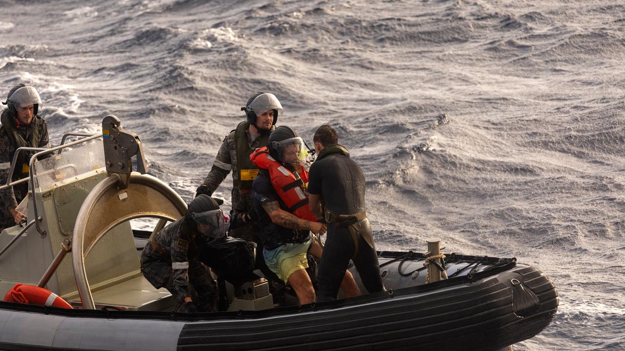
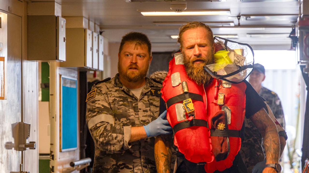
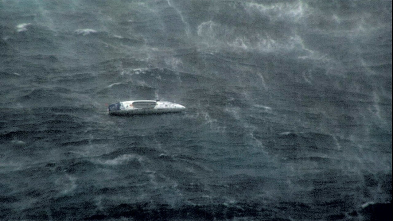
Dramatic pictures released by the Australian Maritime Safety Authority (AMSA) captured the moment Mr Mockus was rescued from the turbulent waters after spending two nights adrift off the coast.
In the photos, Mr Mockus is helped onto the vessel by AMSA personnel.
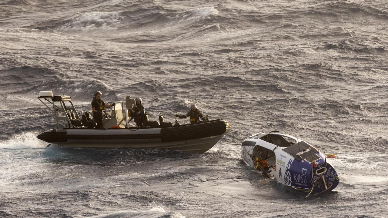
His rowboat can be seen being thrown around in the waves.
Mr Mockus reported no injuries, aside from fatigue on the day his emergency beacon was activated.
AMSA initially tasked the Cairns-based Challenger search and rescue aircraft to find him, but the search was unsuccessful amid heavy seas and 80km/h winds.

After waiting for two days in the pounding ocean, Mr Mockus was rescued by the Royal Australian Navy ship HMAS Choules on Monday morning.
“The ship on its way back to Australian shores,” an AMSA spokeswoman said earlier in the day.
He initially set out on his journey in October 2024 and was days away from reaching his goal, after rowing 70 nautical miles per day.
In a post on his Instagram on February 27, the rower said he was bracing for the “maximum power” from Tropical Cyclone Alfred’s passing.
Another video the following day captured Mr Mockus opening his door to high swells.
He wrote: “And here is not so much what awaits me tomorrow … the highlight is that I successfully sailed the reefs of Chesterfield islands!!”
“The most important thing is to hold back the next few days.”
Tropical Cyclone Alfred, a category 1 system, is situated 465km northeast of Brisbane and 410km east northeast of Maroochydore – in the Sunshine Coast region – as of Monday morning.
It is moving southeast at 20km/h.
The Bureau of Meteorology has forecast Tropical Cyclone Alfred will continue moving towards the southeast through the day, slightly away from the Queensland coast before slowing down and turning westward back towards the Queensland coast on Tuesday.
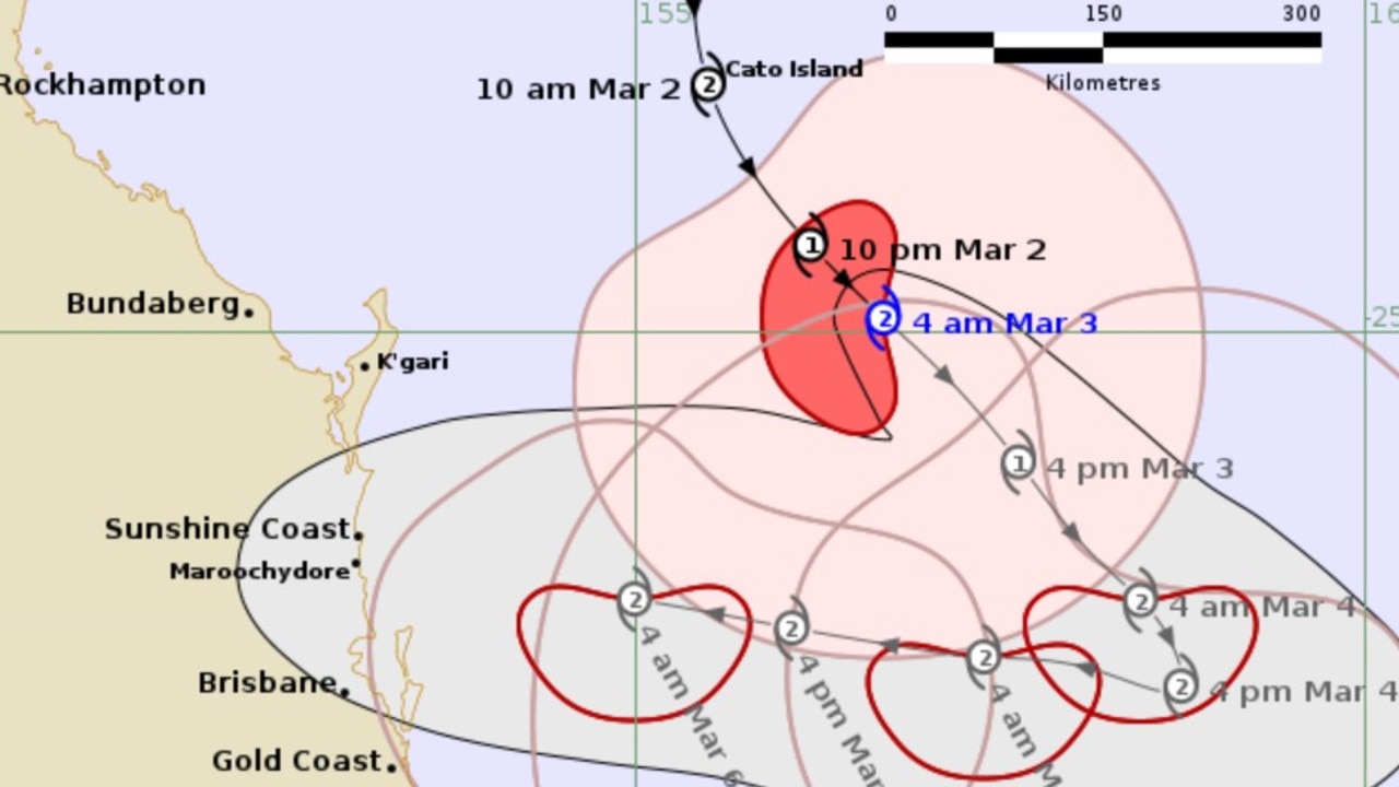
“Alfred is currently a category 1 cyclone but is expected to intensify to a category 2 cyclone tonight (Monday),” the bureau’s latest warning states.
“It is likely to maintain a category 2 intensity as it approaches the southeast Queensland coast late on Thursday.”
The unusual weather event – which has hung around the coastline since last week – has also led to a cyclone watch being issued in NSW, for the first time since 1990.
It marks the first time a cyclone watch had been issued for the southern state since Cyclone Nancy in 1990 and Cyclone Zoe in 1974.
Severe coastal hazards, including abnormally high tides and hazardous surf are expected to continue over southern Queensland and northeastern NSW coasts.
Gales with damaging wind gusts of up to 120km/h are expected to develop along the southeast Queensland and northeastern New South Wales coastal and island communities between Tewantin and Grafton during Wednesday.
More Coverage
These gales may extend north to Sandy Cape – on the most northern point of K’gari (Fraser Island) in Queensland – from late Wednesday onwards.
Heavy rainfall is forecast for both states from Wednesday as Alfred approaches the coast.
Bureau manager hazard preparedness Steven Bernasconi said widespread rain between 100-300mm was tipped for Thursday and Friday, with flood watches in place.

Big step to kick off $25 medicines pledge
Labor will begin its first steps to bring down the cost of PBS-listed medicines from $31.60 to just $25. Here’s how it’ll work.
Read more

Cops shoot ‘wanted’ Aussie man
An allegedly “wanted” Aussie man has been rushed to hospital after he was shot by police officers.
Read more

Man identified after fatal motorsport crash
The motorsports community is in mourning following the death of an experienced racer during a competition.
Read more