
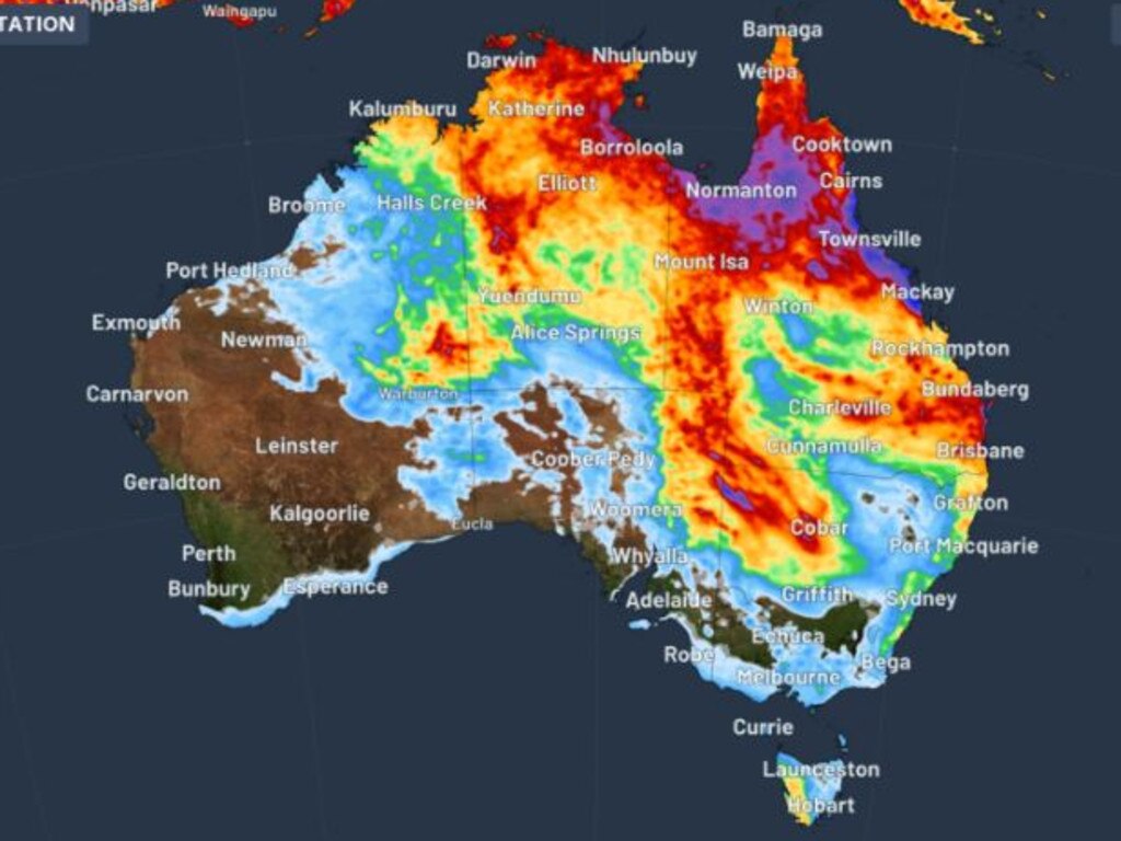
Northern Australia set for pre-Easter showers
Lingering effects of a tropical cyclone are dousing huge chunks of Australia in rain, causing issues on the roads ahead of the Easter long weekend.


Southeast Queensland, the Northern Territory and New Zealand are blanketed in the same monster cloud band which will bring rain and likely issues on the roads heading into this Easter long weekend.
Lingering effects of ex-tropical cyclone Megan and an associated low-pressure trough are to blame.
Brisbane motorists and train commuters have already faced traffic jams and delays because of heavy rain in the past few days and it is only getting worse.
There is flash flooding in at least two suburban areas of Brisbane, overland highways were bumper to bumper Tuesday and at least one train was stopped in its tracks.
The Bureau of Meteorology expects Brisbane to cop up to 40mm of rain for the rest of Tuesday and up to 20mm Wednesday.
Areas north to Bundaberg and inland in the Far North around Strathmore could get up to 50mm of rain Tuesday evening.

The forecast rain dump during the next four days effectively forms an inverse ‘U’ from Brisbane, up to Cape York and then across Darwin and down to the WA, SA and NT border convergence.
NSW is predicted to not receive any heavy rain, perhaps recording up to 10mm on the northeast wedge of the state in the coming days, however there are hazardous surf warnings in place.
Ex-tropical cyclone Megan made landfall as a category 3 system on March 18 on the southwestern coast of The Gulf of Carpentaria, forcing about remote residents to be evacuated to Darwin.
Weekly rainfall totals greater than 200mm were recorded across western, central and eastern parts of the Northern Territory and along the northeastern coast of Queensland, with some areas receiving more than 300mm.

Push to hit Aussie billionaires with super tax
The Greens are leading the call to force Australia’s richest people to pay a “billionaires’ tax” the party claims could rake in nearly $25bn in four years.

Sydney star fit for continental duty
One of Sydney FC’s key players says he’s fit and ready for the challenge that Bangkok United will provide the Sky Blues on Wednesday night.
Cop found dead in Sydney police station
NSW Police Commissioner Karen Webb says ‘it’s a very sad day’ after a police officer was found dead inside the Sydney Police Centre.