Russia-Ukraine will be world’s first ‘naked war’
Russia-Ukraine could be the starkest conflict in history for one obvious reason. In fact, it’s already playing a huge part in how it’s playing out.
Innovation
Don't miss out on the headlines from Innovation. Followed categories will be added to My News.
The fog of war is history.
In the past, we only knew what was happening when the wounded began returning home. Then spy planes and satellites were put in the skies. Now every one of us has access to swarms of real-time social media videos and pictures.
That’s why Ukraine will be the starkest war in history.

The raw reality of Vietnam shocked the world. Children fleeing napalm strikes. Captured soldiers with pistols put to their heads, moments before execution. Such shocking imagery stripped away the gloss of patriotism and propaganda.
And that was primarily due to the efforts of just a handful of reporters.
Ukraine has already revealed how difficult it is for governments to sustain a narrative in the digital era – this will be the world’s first ‘naked war’ where anyone with an internet connection can report on what’s happening. Everybody has intelligence data at their fingertips beyond the dreams of CIA operatives based in 1970s Hanoi.
Belgorod, #Russiapic.twitter.com/FOwx8BZNsX
— marqs (@MarQs__) February 17, 2022
It’s called Open Source Intelligence (OSINT).
“The resources now available to individual citizens approaches those once reserved for the superpowers,” defence analyst Victor Abramowicz argues for the Lowy Institute.
That’s why Moscow’s mobilisation has been tracked every step of the way.
Russian Air Force 🇷🇺 Ka-52s, Mi-17s and what look like Mi-24/35s at an unspecified field at Valuyki.
— Evergreen Intel (@vcdgf555) February 17, 2022
There is an unused airfield at 50.223421°N 38.110431°E with a long building like the one seen in the video. I believe this is the geolocation. https://t.co/lSAMPfv9eQpic.twitter.com/UQhOJWUrRG
Amateur analysts noticed a year ago that Russia had apparently forgotten to take its tanks, trucks and artillery home after regularly scheduled war-games with Belarus.
Over time, commercially available satellite photographs revealed these stockpiles were being added to. Then, come November, Moscow’s efforts to speed up preparations resulted in a flood of footage of trains and trucks hauling military equipment on social media.
It’s all become possible in just the past eight years.
“Social media, big data, smartphones and low-cost satellites have taken centre stage, and scraping Twitter has become as important as anything else in the intelligence analyst toolkit,” says Professor Craig Nazareth of the University of Arizona’s information operations centre. “These technologies have also allowed news organisations and armchair sleuths to follow the action and contribute analysis.”
Open Source Intelligence (OSINT)
Commercial satellites and civilian snaps produce a birds-eye view of the unfolding international crisis. It’s not likely to stop once the shooting starts but not everything can be taken at face value. Deliberate misinformation is regularly being fed into the mix.
This can simply be a troll seeking enjoyment out of sewing chaos. It can also be a concerted campaign by military agents.
But the tools needed to check, validate and verify are also in the hands of the general public.
A lot of footage is being posted online of Russian military movements along the Ukrainian border. We’re working with the #OSINT community to document, verify & map this information. You can find our map of verified movements here: https://t.co/2uqsSML5Qepic.twitter.com/ToGku2xX8G
— Centre for Information Resilience (@Cen4infoRes) February 9, 2022
Picture histories can be searched. Metadata can be extracted. Original sources can be traced. Most importantly, their context can be cross-checked.
That leaves armies with nowhere to hide.
“A plethora of satellite imagery providers generate detailed views of Moscow’s deployment of more than 100,000 troops to Ukraine’s borders,” says Abramowicz.
Google Earth is just one source for commercial satellite imagery. A subscription to its providers – such as Maxar or Planet – will produce images that may be just days old instead of the months or years of the free service.
Then there’s Google Street View.
Is that tank where the poster of a photo or video says it is? Is that train going where Russia’s Ministry of Defence claims?
All it takes is to identify a few landmarks – and then an investment of time to find the corresponding place.
Russian 2S19 Msta-S Self-Propelled Howitzer spotted earlier today in Kazinka, Valuysky District, Belgorod Oblast (17KM from the border with Ukraine) https://t.co/FL3eHF2dT9pic.twitter.com/vevho1xIqN
— Centre for Information Resilience (@Cen4infoRes) February 17, 2022
That allows the image to be oriented. It pins it down in the big picture evolving around it.
An artillery piece with a range of 40km positioned just 20km from Ukraine’s border, for example, is potentially ready for war.
TikTok – time is against the invader
It’s not easy to miss a tank. Especially when it is parked with dozens of other military vehicles across a major intersection.
And that’s proven to be a central sticking point for Moscow’s efforts to conceal troop movements. Frustrated drivers have been pulling out their phones and broadcasting their gripes – and images of what forces are where – to the world.
A convoy of military equipment in Kalinkavichy district (Gomel region, Belarus) yesterday (16.02).
— MotolkoHelp (@MotolkoHelp) February 17, 2022
KamAZ and Ural trucks, armored personnel carriers, fuel trucks and military medical vehicles were seen in the convoy. pic.twitter.com/j3LIOzSeCB
“Despite Russia banning soldiers from using smartphones on duty, now TikTok, Youtube and more provide data allowing for the identification of individual units as everyday people share events that capture their interest – and military deployments clearly fit the bill,” says Abramowicz.
Once Russia invades Ukraine, the TikTok’s won’t stop. Facebook. Twitter. Snapchat. Telegram.
All will be awash with the reality of war.
We’ve already had a taste.
Some of the visual clues to indicate it's the correct location, for fans of coloured boxes (the most useful OSINT tool) pic.twitter.com/Dt6sAVi7pM
— Eliot Higgins (@EliotHiggins) February 17, 2022
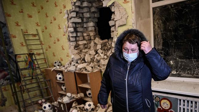
A stray cannon shell struck a Ukraine kindergarten on Thursday evening. Within minutes, both sides were accusing each other of the near-tragedy. Within hours, the kindergarten had been located, the orientation of the classroom established – and the offending shell’s direction of travel identified.

Such open-source intelligence quickly put the lie to Russia’s claim it was all Ukraine’s fault. The kindergarten was inside Ukraine. The shell came from inside occupied Donbas.
“Overall, the veil of high-level secrecy is likely gone for good,” writes Abramowicz. “Any point on the world can be imaged, for a pittance, multiple times per day, rain, hail or shine. And while satellites still need to know where to look, how likely is concealment in a world with billions of phones, the internet, and OSINT communities scouring all types of media for hints of new activity?”
Quality control
OSINT results are not as fast or high-resolution as a military surveillance satellite.
But it gets into the hands of many, many more people. And that means much of what defence agencies miss can be caught by amateurs.
“What you get out of an outfit like Maxar is very good information but not as precise or as timely as that provided to US national leadership,” says retired NATO commander Admiral James Stavridis.
NATO surveillance aircraft have been swarming over Latvia, Lithuania, Estonia, Poland and Romania. We know this because their flight paths are often visible on open-source flight tracking services such as FlightRadar24.
Unprecedented show of force this morning above the skies of #Ukraine.
— The Intel Crab (@IntelCrab) September 4, 2020
Two US B-52 bombers, escorted by the Ukrainian Air Force, flew within 20 miles of the border with #Crimea.
(SS via @cianmarbo) pic.twitter.com/KWnF1WvMJK
Their mission has been to intercept radio transmissions and radar signals to pinpoint and confirm other intelligence data sources.
That’s the level of verification needed for militaries to believe their eyes.
“You can see something on a base that looks like a lot of activity,” says Federation of American Scientists analyst Hans Kristensen. “But in terms of what’s being done there and what the units are — that takes a lot more intel.”
And Western intelligence agencies have learned the power of truth. Washington has been unusually forward in sharing up-to-date intelligence assessments about Moscow’s troop movements and espionage operations.
Sentinel-2 imagery of the new helicopter base at Tomarovka airfield, geolocated by @bobmoretti.
— Michael Sheldon (@Michael1Sheldon) February 17, 2022
Comparison between Feb 05 and 15. https://t.co/Ap0AepRFXtpic.twitter.com/4SYRuvWiy3
It’s a deliberate tactic aimed at stripping away any chance of “plausible deniability” when it comes to staged “false flag” (fake provocative) acts.
It also feeds the activities of independent OSINT enthusiasts.
On Thursday, Moscow announced it was withdrawing its troops from Belarus.
NATO chief Jens Stoltenberg immediately cast a shadow over these promising words.
“What we see is that they have increased the number of troops, and more troops are on the way,” he said.

Within hours, pictures and videos verifying his caution were flooding the internet.
A matter of resilience
Once, all it took to isolate a community was to seize its telephone exchange and arrest the postman.
The job is similar, though somewhat more extensive, nowadays.
Phone networks may be taken down. Internet cables can be severed. Electronic warfare equipment can jam signals.
But homeowners have long had the option to buy their satellite uplinks. And footage recorded on a mobile phone needs only a fleeting connection to get out into the world.
â„¹ï¸ Update: Mobile internet service is returning to Vodafone subscribers in #Luhansk, eastern #Ukraine, after a network disruption that lasted over an hour and had high impact near the border with Russia.
— NetBlocks (@netblocks) February 17, 2022
📰 Report: https://t.co/d8QWF8m0Kzpic.twitter.com/A1oEXeiv4j
“Countries might seek to temporarily blind satellites that pass over them,” says Abramowicz. “But this risks contention with asset operators and requires advanced technologies to know which satellites are where, and to precisely control energy beams.”
About 61 per cent of Ukrainians own a smartphone. The nation’s infrastructure is far more advanced than Syria, Iraq or Afghanistan. And those on the borders can access the services of neighbours such as Poland.
Even with phone networks being taken down and internet services severed, the flood of material out of Ukraine is likely to be overwhelming.
But verification takes time.
“Technology has produced a flood of intelligence data, but technology is also making it easier to extract meaningful information from the data to help human intelligence analysts put together the big picture,” says Professor Nazareth. “However, sifting through terabytes of publicly available data for relevant information is difficult. Knowing that much of the data could be intentionally manipulated to deceive complicates the task.”
Spies from the DPR managed to get 'exclusive' intelligence from the Ukrainian General Staff regarding their upcoming plans to retake occupied territories.
— The Intel Crab (@IntelCrab) February 17, 2022
...right...https://t.co/utmZzIesCR
Human nature is also a factor.
The excitement of being the first to share a dramatic clip is a human trait propagandists are well aware of.
But swarms of OSINT activists are reducing even this threat.
“We’ve left the era of trust and verify, and we are in an era of don’t trust unless you can verify,” says former deputy assistant secretary of defence Mick Mulroy. “We should use all of our intelligence assets available to do just that.”
Whatever the case, war has changed. Forever.
“Perhaps the most that can be said with certainty is that concealment, and implausible deniability, will become more difficult,” says Abramowicz. “And in a world of otherwise increasing disinformation, this might just help stop some conflicts before they start.”
Jamie Seidel is a freelance writer | @JamieSeidel
Originally published as Russia-Ukraine will be world’s first ‘naked war’


