
Google Earth plug-in puts property sales data on the map
NOSY neighbours rejoice: you can now use Google Earth to check how much that house around the corner sold for.

Business Technology
Don't miss out on the headlines from Business Technology. Followed categories will be added to My News.
HAVE you ever wondered how much your neighbour’s house is worth?
Well, now you can use Google Earth to not only peek at their backyard, but also see how much they paid for it.
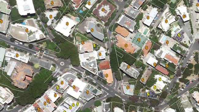
Residential sales prices for the last 14 years can now be viewed using a free plug-in that combines the satellite mapping technology we’ve come to rely on, with official property sales data.
It makes keeping up with the Joneses just that bit easier — but so far the function is only available in NSW.
In the past, nosy neighbours had to fork out for an RP Data search, which is fine if you have a serious property deal in the works, but too much hassle for those who merely want to satisfy their curiosity.

Now it’s possible to keep track of Sydney’s booming property market with detailed individual property sales histories using NSW Globe, a plug-in that works in conjunction with Google Earth.
Charts summarising the sales data across streets and suburbs is also available through the application, which delivers on a Baird Government election commitment to greater public access to data, which does not include the names of buyers or sellers.
NSW Finance Minister Dominic Perrottet said the service aimed to bring property information services into the digital age, in a state where $120 billion worth of property deals take place each year.
“The Government recognises that in a booming property market, buyers and sellers are entitled to accurate and accessible land and property information,” Mr Perrottet said.

“Providing that data for free is just one of the ways this government is making it easier for people embarking on what will be for many, the most significant financial investment they will make in their lifetime ... The people of NSW can now make affordable and informed choices when buying and selling property.”
Other states and territories have versions of NSW Globe that provide limited spatial data including land parcels, property addresses, road information and land valuations across the state, but NSW is the first state to include property sales data.
Core Logic RP Data executive general manager Craig Mackenzie has previously warned of potential privacy impacts of the technology and questioned whether it had the capacity to “confuse the public, who may not fully understand it”, according to Fairfax.
Users must download and install Google Earth along with the NSW Globe plug-in to access the sales data, which is based on information provided to Land and Property Information when properties change hands.
The NSW data, which can be used to analyse property market trends, will be provided in an open format to third party providers like News Corp’s realestate.com.au by the end of October.
When Google Earth is up and running, users can select and deselect different data points on the map, alongside the usual 3D buildings and landmarks.
In the last financial year, LPI recorded 214,869 property sales transactions and received 4.4 million requests for land title information.
Originally published as Google Earth plug-in puts property sales data on the map

Why Goodman’s AI pivot has a big message for investors
The veteran property investor is replaying the strategy that turned a small commercial property trust into a $70bn industrial powerhouse.

Thousands of dodgy job ads banned
A growing problem for Australians trying to find a job has been revealed, as the number of red flags continues to soar.