‘Wettest July in decades’ for parts of Australia likely following soaking week
A conveyor belt of cold fronts is set to batter large swathes of Australia plunging temperatures and bringing rain not seen in winter for years.

Environment
Don't miss out on the headlines from Environment. Followed categories will be added to My News.
It’s going to be a week marked by cold front after cold front as the country’s south west and south east receive a Groundhog Day of blustery and wet weather.
Meteorologists have said it could be the “wettest July for decades” in Western Australia’s south with each new front bringing a fresh dumping of rain.
But Sydney and Brisbane are looking at far more pleasant conditions with the mercury topping out in the mid to high twenties during a sunny winter week.
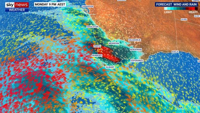
A “powerful system” will barrel across Perth and the surrounding regions late on Monday and into Tuesday bringing huge waves, damaging winds and abnormally high tides, said Sky News Weather meteorologist Rob Sharpe.
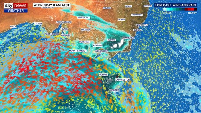
On Tuesday, that front will reach South Australia followed by Victoria and Tasmania on Wednesday which could lead to more heavy snow on the Alps and cold temperatures.
“Back in the south west, the next round comes through on Thursday night with probably some severe weather with that one as well and more rain,” said Mr Sharpe.
“It’s been exceptionally wet so far this July in the south west; many areas will have seen their wettest July for decades by the time we get to the end of the month.”
Yet another front will head over Perth on Friday.

‘Wettest July in decades’ for Perth
All of those will head towards the south east in a conveyor belt of cold and wet conditions.
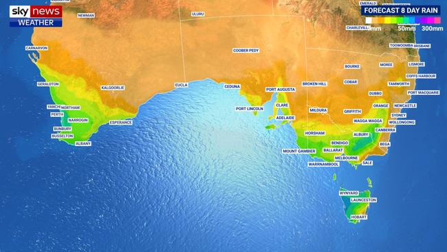
More than 100mm could fall on western Tasmania over the coming eight days and 50mm or more over particularly north and eastern Victoria. Perth could see between 50 and 100mm during the week.
Heavy rain in Perth on Monday with up to 50mm falling with those showers easing into Tuesday. But they’re not giving up completely so keep the umbrella handy all this week.
Heavier rain kicks back in again on Thursday and there could be up to 20mm on Friday with a storm to boot. Highs of between 18-20C this week in Perth with lows bouncing around 10C.

WA’s cold fronts then head east
Some rain for Adelaide on Tuesday and Wednesday with heavier falls on the weekend. A maximum in the city of 19C on Tuesday but that will fall to 15C on Wednesday before warming up a touch for the rest of the week. A low of 7C early on Thursday but 10C most other days.
A few showers here and there for Melbourne this week, but the heaviest falls aren’t likely to be until the weekend. Temperatures should swing between 7C-10C lows and 15-17C highs.
Generally heavier falls the further inland you go with up to 10mm falling in Wangaratta on Wednesday. Falls Creek could see up to 30mm of snow midweek with similar dumps at the other Victorian resorts.
Rain a possibility all week during a windy few days in Tasmania. But in Hobart the falls shouldn’t be too heavy.
But it could be very soggy towards the north and west of the island with 15-25mm hitting Burnie between Tuesday and Wednesday and up to another 35mm on the weekend.
Highs in Hobart of 15C this week falling to 6C on Thursday and Friday morning.
Wednesday in Canberra could be wet with 10mm falling. Mostly isolated rain falls for the rest of the week. A low of -4C on Friday but the minimums should be in positive territory leading up to that. Highs will be relatively constant this week in the mid-teens.

Toasty on east coast
A dry and sunny week in Sydney, almost getting toasty with a maximum of 24C on Wednesday and 26C on Sunday – although 20C will be the standard. Lows of 10C but it could be colder heading into the weekend.
Brisbane also seeing a sunny seven days topping out at 25C on Wednesday and Thursday. A toasty 33C in Darwin with lows of 21C.
Originally published as ‘Wettest July in decades’ for parts of Australia likely following soaking week


