Warnings of thick blanketing of fog for coming days across east coast
The monster rain event is finally on its way out. But in its wake a new weather hazard is emerging, which could be just as dangerous.

Environment
Don't miss out on the headlines from Environment. Followed categories will be added to My News.
Just as the clouds clear and the sun begins to shine on the east coast, motorists in particular are facing a new weather worry.
Thick fog could descend across vast tracts of the east coast and inland as the rain event clears and the sun begins to shine.
“There may be some areas of the state that will see some fog so be really mindful that you may not be able to see those hazardous conditions on the roads into the weekend,” the Bureau of Meteorology’s (BOM) Agata Imielska said today.
The coming days could provide the ideal weather conditions for fog formation as the rain front heads off into the Tasman.
It’s left masses of moisture in the wake. With fewer clouds to keep things warmer overnight, the air can drop to what is known as “dew point temperature”. This is the temperature at which condensation occurs.
At this point, all that water vapour turns into tiny water droplets that hang in the air, forming fog. It’s the same process by which clouds are formed, but it occurs at the surface.
RELATED: Follow the latest flood updates as they happen

Fog most commonly builds at night and stays around until it burns off through the morning as the mercury rises.
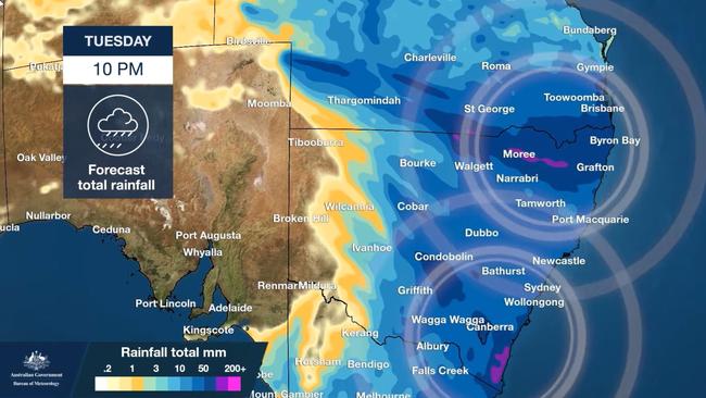
What’s striking about the possible fog for the coming days is just how wide it could stretch. Essentially, that’s as far as the rain event has stretched.
So anywhere from south east Queensland to far south New South Wales and beyond could see a foggy start to the coming days.
Helen Reid, a meteorologist at the BOM, told news.com.au areas including Sydney’s west, the mid north coast, and the state’s south coast could see fog. However, with rain lingering on the western slopes, that area may escape the mist.
“The fog is set to be extensive; quite the blanket. That’s not to say everyone will see it but it should be widespread.”
She warned motorists to be extra careful as the fog was set to be more like a thick covering than patchy. It could mean the entire journey to work is shrouded in cloud.
However, the BOM has said the fog is not a dead certainty. Warmer temperatures and stronger winds can all mean it doesn’t form or is blown away.

RELATED: Nightmare weather moving south
NSW and Queensland will finally see the back of the system today as the front shifts out to sea. But parts of eastern Victoria and Tasmania are now in the spotlight. Very heavy rainfall is forecast for those regions and the Bass Strait.
Meanwhile, meteorologists have said flooding in the east could last for months, even after the sun comes out.
“Coastal catchments tend to respond very quickly. So, as that rain clears the situation can improve,” said meteorologist Victoria Dodds.
That doesn’t mean the floodwaters will recede immediately. In western Sydney, the mid north coast and the south coast of NSW as well as Queensland, rivers could remain high until the weekend as that rainfall washes out to sea.
But as we head into the weekend, with little extra rain, rivers should begin to return to normal levels.
However, that is certainly not the case west of the Dividing Range.
“In western New South Wales, once the rivers get going, they can keep flowing for not just days but weeks or months on end, as the floodwaters make their way through the state,” said Ms Dodds.
The issue is manifold. In the interior, the land is relatively flat, so the water is given little encouragement to drain. And the distance that water has to cover is vast before it finds its way to a major river like the Murray or to Lake Eyre.
Originally published as Warnings of thick blanketing of fog for coming days across east coast


