
Warning as damaging winds of up to 100km/h to smash southeastern states
Millions of Australians are being warned to brace for wild weather as storms, strong winds and hail.

Environment
Don't miss out on the headlines from Environment. Followed categories will be added to My News.
Damaging winds are forecast to hit the nation’s southern states over the coming days, with locals warned to prepare for the severe weather.
A series of powerful cold fronts are expected to move over the southeast bringing wintry conditions, including rain, hail and snow.
The weather warnings are expected to be issued for the weekend, as temperatures are predicted to plummet, Weatherzone said.
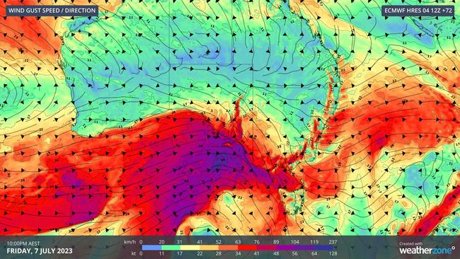
The front is pushing east from its origin in Western Australia and is due to arrive on Thursday.
Wind and showers will increase over South Australia before a second cold front arrives on Friday.
“Cold air behind the front will also produce small hail and highland snow in some areas, adding to the wintry feel of this system,” Weatherzone meteorologist Ben Domensino said.
The front will cross the border of South Australia on Saturday bringing strong winds and potentially damaging gusts to parts of Victoria, Tasmania and NSW.
Regions expected to face the severe weather include the Mount Lofty Ranges in SA, parts of central Victoria, and the Blue Mountains and Illawarra coast in NSW.
The system will likely impact the ACT between Friday and Sunday.
NSW
The cooler conditions which are set to arrive on Thursday will be a welcome change after a rare spotting of rain over NSW and the ACT earlier in the week.
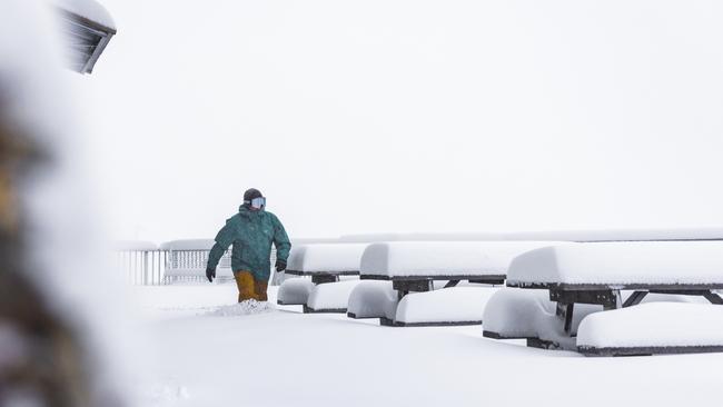
“A series of vigorous cold fronts will sweep across the southeast, generating heavy snowfalls with totals at higher elevations likely to exceed 50 centimetres by Monday,” Weatherzone said in a statement.
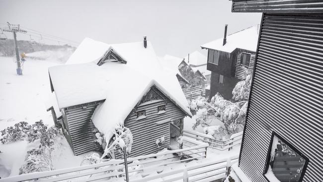
A snowstorm is forecast to blast the Alpine regions by Thursday, with up to 80cm of snow set to fall in the following days, Perisher ski resort reported on their website.
Rain will persist throughout Wednesday with limited visibility making for less than ideal snow sport conditions.
However, a dumping of fresh snow will set weekend skiers and snowboarders up for a bumper powder weekend.
ACT
A chilly week is ahead for residents of Canberra with daytime temperatures dropping to a maximum of 13c.
An icy morning with a low of 1C is expected on Thursday.
The cold fronts sweeping across the east coast will bring with them gusty winds of about 25km/h.
The most powerful winds will arrive over the weekend with up to 40km/h gusts.
Victoria
A rainy and cold week ahead is forecast for residents of Melbourne with daytime temperatures unlikely to exceed 15C for the next seven days.
Persistent showers and wind will remain consistent in the coming days, with gusts of up to 45 km/h expected on Thursday.
Snow is forecast to fall over Mt Hotham ski resort on Wednesday evening setting the resort up for powder conditions over the weekend.
Originally published as Warning as damaging winds of up to 100km/h to smash southeastern states

Albo’s power pledge to save Aussies $2300
Homeowners could see their yearly power bill slashed by up to 90 per cent following a new pledge by the Prime Minister.

Big change as daylight saving ends
Daylight saving ended in a number of Australian states at 3am Sunday morning. Here’s what you need to know.