
Tropical Cyclone Alfred could make landfall early Saturday morning, authorities urge people to stay off beaches
Authorities are warning millions to brace for worsening conditions from Tropical Cyclone Alfred, more than 24 hours before the category 2 storm is expected to cross the coast.
Residents of 7000 homes have been given just hours to evacuate, with Tropical Cyclone Alfred expected to bring major flooding in areas that were devastated in the 2022 floods.
The impact from Cyclone Alfred, which is not expected to cross the coast until early Saturday morning, will bring wild weather and heavy rains to southeast Queensland and northern NSW overnight.
Public transport and schools have been closed in Brisbane and the Gold Coast, with expectations that winds and heavy rain will intensify over the 24 hours before Alfred finally hits the mainland.
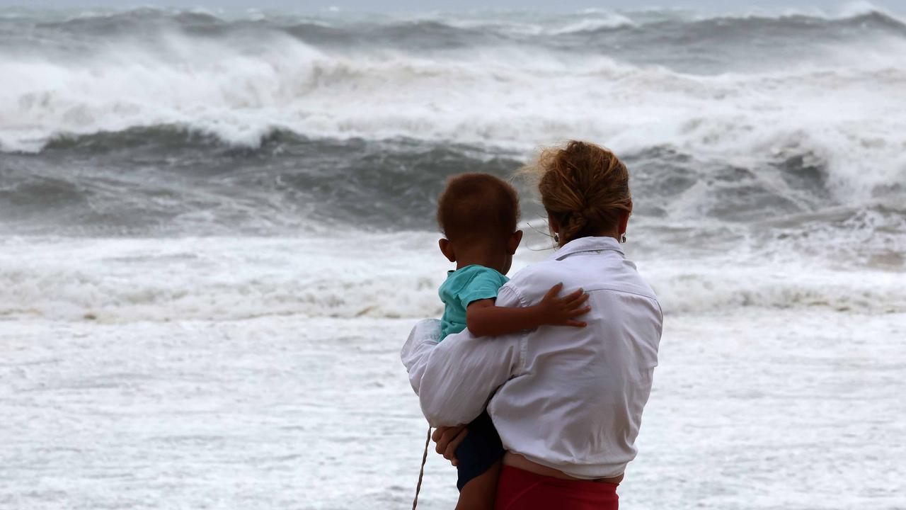
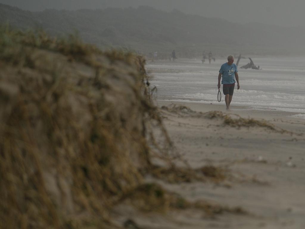
Authorities in Queensland are warning people to stay away from the beaches as massive waves pound the coast.
Parts of northern NSW have already been experienced intense rainfall, with 200mm recorded at Dorigo and 170mm at Mullumbimby.
Evacuation orders were issued to residents throughout the Northern Rivers region of NSW with people told to take refuge with family or friends, or evacuation centres by 9pm on Thursday.
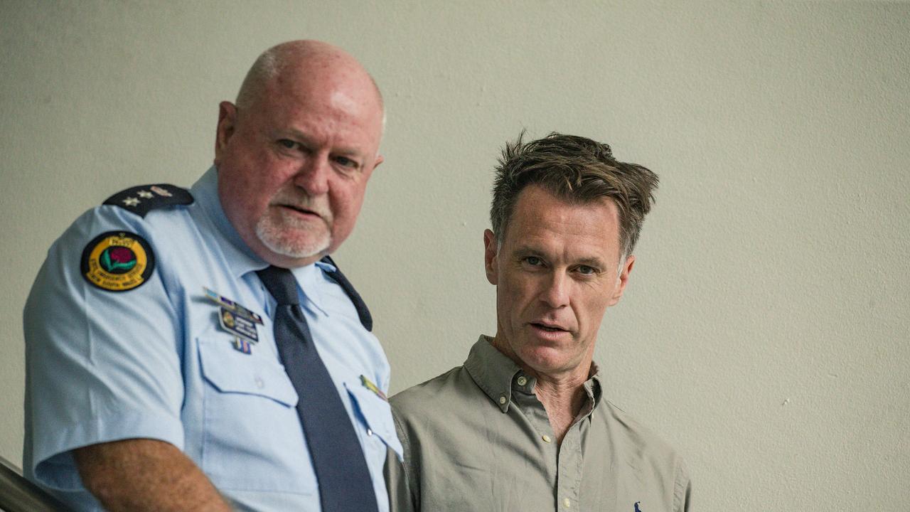
NSW Premier Chris Minns said from Lismore it was possible people could become trapped and would be without power, water or other essential services for an extended period of time.

“We’re forecasting very heavy rain, and in the event of very heavy rain evacuation routes may be closed,” he said.
“If you don’t have a safe place to go, (authorities) have established evacuation centres across the Northern Rivers.
“We cannot guarantee a boat for every house in the flood evacuation zone in the event of a major overflow of these rivers, particularly overnight.
“So the way to keep yourself and family safe over the next few hours is to evacuate before 9pm, we couldn’t be clearer about that.”
Mr Minns said 10,000 home and businesses in northern NSW were without power and emergency service crews were working to get the power restored to those communities.
He said it was very dangerous in some areas and they may have to wait until the storm danger had passed before they could safely put crews back on site.
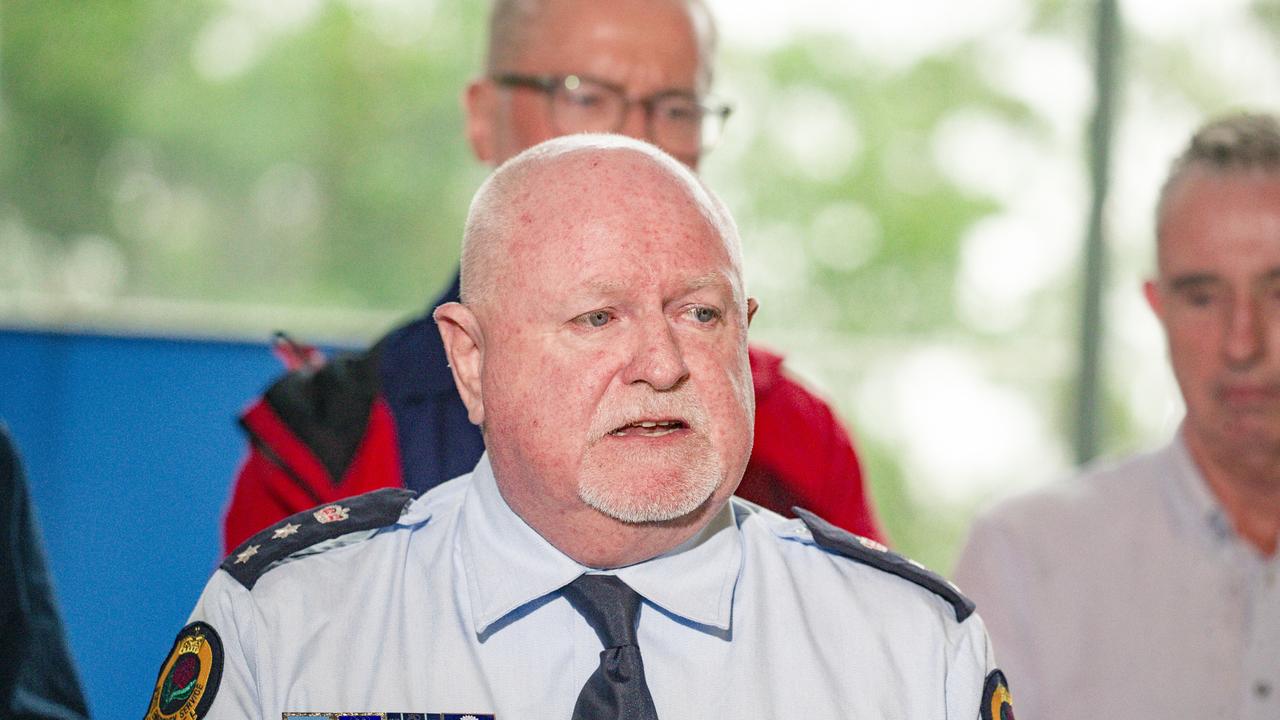
NSW State Emergency Service acting chief superintendent Stuart Fisher said the weather was deteriorating rapidly and while it may not look like the rivers were flooding, there was concern they would flood overnight and on Friday.
Mr Fisher said they expected further evacuation notices to be issued over the next three days.
“Our main concern at the moment is when that wind comes through, the wind will bring down the powerlines and bring down the trees, which may stop emergency services getting to you when flooding occurs,” he said.
“Do not underestimate this storm.
“The prediction is it will hit us and the three-pronged attack beginning with coastal erosion, followed by strong winds and torrential rain that will come over the next three days.”
Jet skier reported missing on Gold Coast
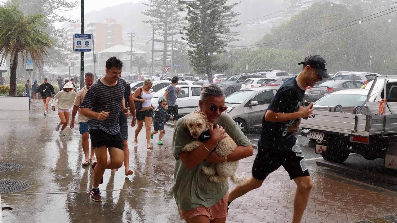
A jet skier has been reported missing, as authorities beg surfers and sightseers to stay off the beaches as Cyclone Alfred brings wild weather to the coast.
Incredible images taken on Thursday afternoon showed Gold Coast residents sprinting for cover as heavy rainfall and winds began to lash the area.
Those in Burleigh were seen running for shelter, carrying their young children and even one woman who was carrying her dog, during a torrential downpour.
In an updated on Thursday afternoon, police on the Gold Coast said they were investigating after a trailer with a jet ski missing was found.
“We are unsure if we are now looking for a person who was on a jet ski,” Acting Chief Superintendent Peter Miles said.
“What is paramount for us is that person’s safety, but to know that there was someone out on a jet ski in this type of weather is quite concerning in the first place.
“So please, just stay away.”
He said now was not the time to be on the beach or near water.
“We all need to be a bit more smart about this and ensure that we don’t have any unneeded rescues or potentially worse where we’re looking at fatalities,” he said.
“I just want to reiterate – being on a beach, there’s no place for it at the moment.
“This isn’t a sunset where you can take a nice picture. You’re dealing with Mother Nature at her wildest.”
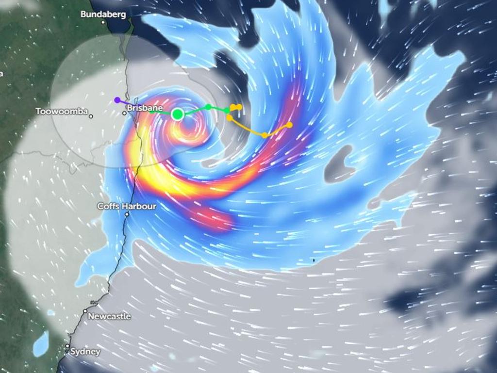
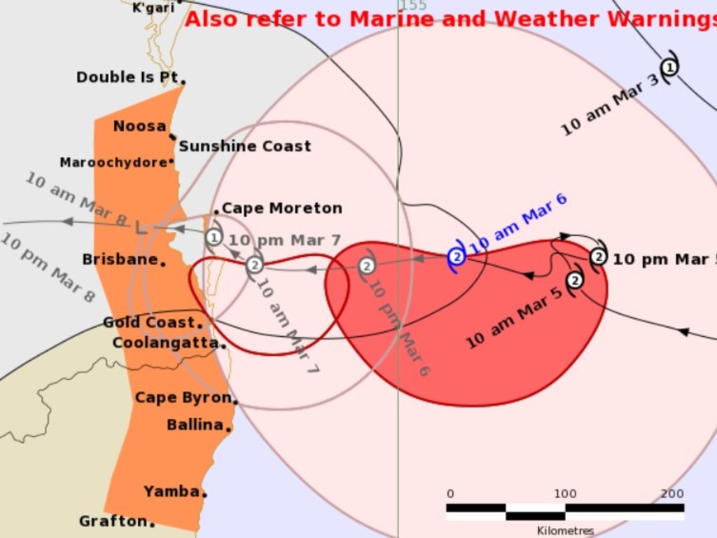
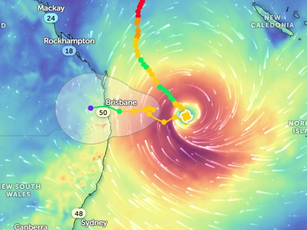
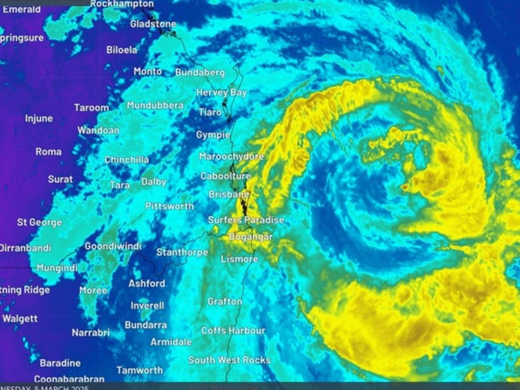
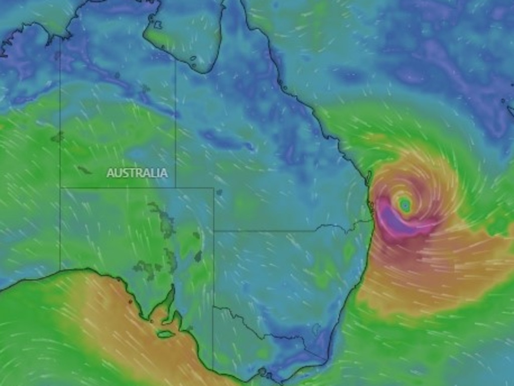
Cyclone Alfred is now tipped to make landfall on Friday night or early Saturday morning after the system slowed overnight.
The category 2 cyclone was moving slowly to the populous southeast corner of Queensland, 225km east of Brisbane and 215km east-northeast of the Gold Coast on Thursday evening, moving west northwest at 6km/h.
On those forecasts, its expected to cross the coast between Noosa on the Sunshine Coast and Coolangatta on the NSW/Queensland border.
But Alfred is already impacting the region, with conditions expected to worsen during the night.
A warning zone was issued for Double Island Point in Queensland to Grafton in NSW, including Brisbane, the Gold Coast, the Sunshine Coast, Byron Bay and Ballina but not including Grafton.
The latest forecast predicts the cyclone will make landfall between Noosa and Coolangatta “very early (on) Saturday morning), after the cyclone slowed overnight.
“Tropical Cyclone Alfred has been oscillating offshore of the southeast Queensland coast. Alfred’s approach to the southeast Queensland coast has slowed,” the Bureau of Meteorology stated in an alert.
The category 2 cyclone is tipped to maintain a similar intensity until the centre “starts to interact” with the coast and islands.
Flights halted
Meanwhile, the wild weather has resulted in the suspension of both Qantas and Jetstar flights from Brisbane Airport (BNE), Gold Coast Airport (OOL), Ballina Airport (BNK) and Coffs Harbour Airport (CFS) as of midafternoon Thursday.
At Brisbane Airport (BNE) and Gold Coast Airport (OOL) international flights are suspended until at least midday Saturday and domestic flights are suspended until at least Sunday morning.
At Ballina Airport (BNK) Qantas and Jetstar flights are currently suspended until at least Sunday morning.
At Coffs Harbour Airport (CFS) – Qantas flights are expected to resume on Friday.
At this time, flights to and from Sunshine Coast Airport (MCY) and Hervey Bay Airport (HVB) continue to operate.
Virgin flights are operation to a “limited schedule” to and from Brisbane Airport as of Thursday afternoon.
Virgin flights from Gold Coast Airport (OOL) are suspended from Thursday afternoon until midday Friday.
Virgin flights to and from Ballina Airport (BNK) are suspended until Friday.
Both Virgin and Qantas are updating their flight schedule changes frequently on their websites.
Why overnight change to cyclone is bad news
Sky News Weather meteorologist Alison Osborne earlier said the system moving slower had the potential to cause worse flooding, particularly in northern NSW.
“It can be (worse than a faster moving system) because it prolongs the time that I’d consider the cyclone to be impacting a region,” Ms Osborne told NewsWire.
“So it can lead to heavier amounts of rain … more prolonged and high end flooding, particularly south of where that system crosses.
“Potential for worse flooding (in northern NSW) because that system is slower.”
She said the slower movement did not mean it was a “weaker system”.
Anthony Albanese said the cyclone slowing was “not all good news” while speaking at a press conference on Thursday.
“It is important to stress it’s still anticipated this will cross into land and will reach landfall, it will just do it later,” the Prime Minister said.
“And a risk is, of course, that in slowing up, it increases in its intensity – but at this stage it is still predicted to be category 2 as it crosses onto land.”
However, Ms Osborne said Brisbane and the Gold Coast would likely experience the worst impacts of wind overnight on Friday into Saturday morning in line with the latest forecast of Cyclone Alfred’s path.
“Previous estimates were for the heaviest rain to occur on that 24 hour period on Friday – the heaviest rain from the system now looks to be Saturday south of Brisbane to Grafton,” she said.
“Essentially, the heaviest rain will be in that 24-hour period following coastal crossing.”
The cyclone was initially expected to cross the coast in the early hours of Friday morning.
However, a bureau report indicated the cyclone could make landfall as late as Saturday.
“The consensus is now for slower westward motion and, as a result, a delayed time of coastal crossing,” the report stated.
“The latest track indicates a coastal crossing is more likely during early Saturday morning.
More than 1000 schools shut
Queensland Premier David Crisafulli said more than 1000 schools and 324 early childhood centres were shut on Thursday as the cyclone loomed.
“There are 1030 schools closed today and there will be that same amount closed tomorrow,” Mr Crisafulli said at a press conference.
He said information would be provided the day prior to any closures to ensure parents can put plans in place.
Elective surgeries were also cancelled on Thursday and Friday, however hospitals will remain open for emergency procedures.
“We have actually rostered to make sure that can occur, and I do want to thank the health staff, many of whom will be, in fact, spending their time at those hospitals and overnighting in many cases to be able to then serve the community the day after,” Mr Crisafulli said.
Most forms of transport have also been disrupted by the early effects of the cyclone.
“We are endeavouring on the roads and bridges that we control, to keep them open for as long as possible,” the Premier said.
“My message to Queenslanders is if you don’t have to be on the road, the best place is at home.”
“Public transport is closed today and tomorrow, and, again, we’ll keep people posted on that.”
Over in NSW just under 330 schools were shut ahead of the cyclone.
Supermarkets may close early
Mr Crisafulli said decisions would be made about supermarket closures on a “case-by-case basis”.
It’s understood nine Queensland Coles stores were closed on Thursday as well as four in northern NSW out of 170 stores in the affected areas
A Woolworths spokesman said stores may begin closing early following weather warnings.
“We aim to keep our stores open as long as possible; however, our store teams will adjust their hours according to safety, advice from local authorities and team member availability,” the spokesman said.
Aussies were urged to check operating hours on the Woolworths website, while the spokesman said stores in the affected areas were receiving extra deliveries of essential products, including pasta, rice, soup, nappies, baby food and formula, milk and frozen vegetables.
“To ensure everyone has fair access to essentials we ask customers to be mindful of others and buy only what they need. We’re very grateful for their patience and for treating our store team members with respect and care,” the spokesman said.
“Our distribution centres in the region have been receiving additional stock, which will be delivered to stores once it is safe to do so and stores have reopened.”

‘Last day’: Stern warning ahead of cyclone
Northern NSW residents were warned that Thursday was the “last day” to get ready ahead of the cyclone should they wish to stay rather than evacuate.
“Today will be their last day to prepare their properties should they wish to say,” NSW SES acting chief superintendent Stuart Fisher said at a press conference on Thursday.
“If they don’t feel safe, they should think about moving out, and today will be that day for that decision.”
He said high winds could bring down trees and power lines when the cyclone makes landfall, which could leave people — and emergency crews — unable to get in and out of affected communities.
“Today is the final day you can prepare your homes. If you feel unsafe, prepare to leave, and leave before tomorrow,” he emphasised.


Effects of cyclone likely to last days
Ms Osborne said parts of Queensland were likely to feel the effects of the cyclone for days, with areas along the coast between Coolangatta and Ballina already feeling the impact.
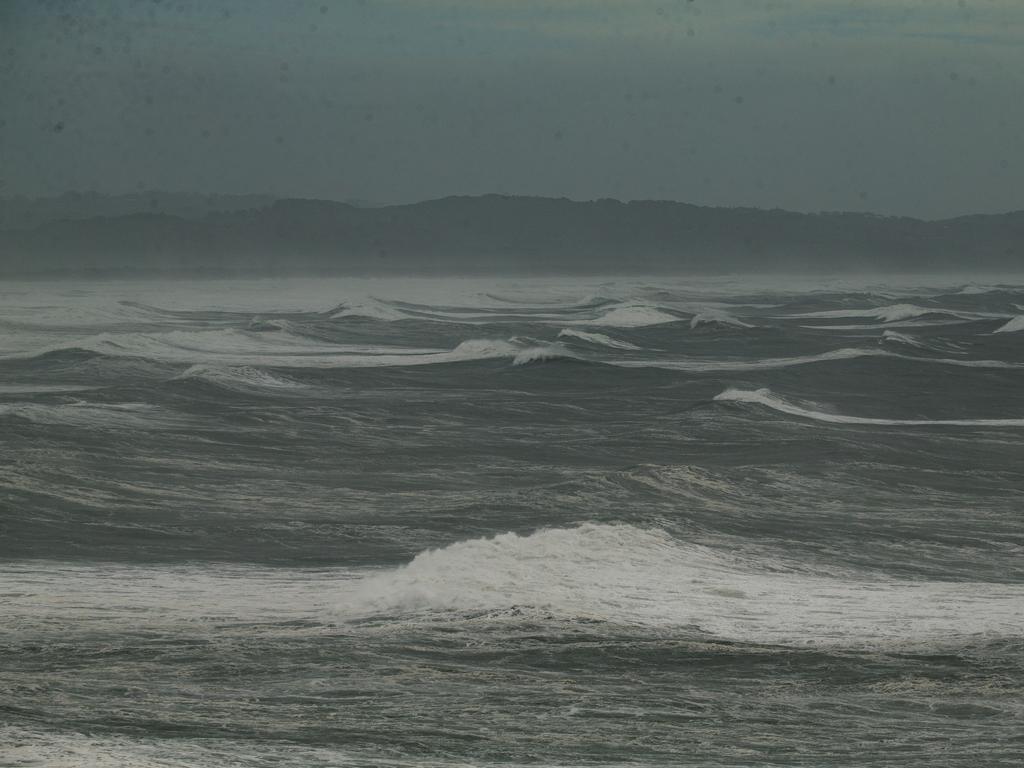
“In terms of impact I’d say for those locations this is very much an underway event with those impacts, particularly today being the risk of abnormally high tides, damaging surf, coastal erosion and tidal flooding,” she said.
“Those impacts are likely until Saturday at this stage.”
She said Brisbane would likely experience winds until Saturday, however rain would likely not ease until Sunday if the city were to take a “direct hit”.
“If Brisbane takes a direct hit the most dangerous winds and the heaviest rain at coastal crossing – so Friday night into Saturday – that’s likely to be over the Gold Coast and the Byron coast,” she said.
“So if you’re talking about the time that Brisbane will be impacted by dangerous winds with an actual coastal crossing, the winds are picking up from now but we’re looking at … gales throughout tomorrow, and then coastal crossing Friday night into Saturday morning.
“The winds should die from around Saturday but the rain is unlikely to ease until Sunday.”
Rare 12m wave recorded off Gold Coast beach
Mr Crisafulli said a 12.3m wave was recorded off Main Beach in the Gold Coast.
He said the system “certainly packs a punch” while speaking on Sunrise Thursday morning.
“To give you an indication of the kind of severity of it, we recorded a wave — I just got briefed a moment ago, 12.3m off the coast of the Gold Coast at Main Beach, which we have never seen a wave height recorded like that,” Mr Crisafulli said.
“So it is a strong system and that delayed run into the coast does give people who may not have finished their preparations that little bit more of a window.
Mr Crisafulli said the cyclone had done a “loop on itself” overnight, which delayed the predicted landfall time frame.
“That is pretty rare but it can happen. And in the end it gives people a little bit more of a window but it still remains a category two,” he said.
“It still has most things we speak about, strong winds and potential for a lot of rain.
“I have every confidence we have done the little things that make a big difference and increasingly I do believe people are taking the event seriously, and that gives people the best chance, so make sure you know if you are in one of those storm tide surges or in a flood zone.
“If you’re not in that area the vast majority of people, get your home ready, remove loose items, prepare to be able to bunker down with your family and you’ll get through it.”

Millions of Aussies ‘in harm’s way’
Federal Treasurer Jim Chalmers said millions of Australians were “in harm’s way” ahead of Cyclone Alfred making landfall.
“There’s a lot of people in harm’s way here. We’re talking about something like 4.5 million Australians potentially in harm’s way, 1.8 million homes, and we expect there’ll be billions of dollars of damage done by Cyclone Alfred,” Mr Chalmers said while speaking on the ABC.
“The best we can do is prepare and stay informed, make sure that people are accessing all of the relevant information and getting it from trusted sources.
“But it’s going to be a difficult couple of days.”
Crews ready to evacuate 20,000 NSW homes
NSW Premier Chris Minns told Sky News emergency crews were ready to evacuate up to 20,000 homes as the cyclone looms.
The NSW SES earlier issued a watch and act severe weather alert on Thursday morning, urging people between Tweed Heads and Evans Head to stay inside unless directed to evacuate.
The alert was issued for those in Tweed Heads, Murwillumbah, Mullumbimby, Byron Bay, Kyogle, Nimbin, Lismore, Lennox Head, Ballina, Casino, Woodburn, Maclean, Yamba, Kingscliff, Coraki, Wardell, Broadwater and Evans Head.
“You should monitor the situation as it is constantly changing,” the alert read.
SES is advising people to STAY INDOORS due to impacts from Tropical Cyclone Alfred UNLESS they have been directed to evacuate due to expected flooding. Damaging wind gusts, heavy locally intense rainfall, severe coastal hazards such as abnormally high tides and hazardous surf. pic.twitter.com/WpVDhs94DR
— NSW SES (@NSWSES) March 5, 2025
Most ‘severe’ weather in years
NSW state emergency operations controller Peter Thurtell said NSW was expecting some of the most severe weather the state had recorded in years.
“We are expecting some of the most severe weather conditions this state has seen in recent years hitting our northern coast in the coming days,” Mr Thurtell said.
The government has opened the State Emergency Operations Centre in Homebush to provide assistance and intelligence to emergency services in affected areas.
“Opening the State Emergency Operations Centre is not a light decision; it should be a clear sign to the NSW public – especially those living in Northern Rivers and Mid North Coast areas – that we are expecting extreme conditions,” Mr Thurtell said.
“The combination of high tides, excessive rain and extreme winds will cause flooding and dangerous conditions on our roads.
“I am urging all NSW road users to avoid driving during these weather conditions.
“Anyone who does choose to drive will be putting their own life, your passengers’ lives and the lives of emergency service personnel at risk.”
Scam text ahead of cyclone
Aussies have assured power would not be switched off by energy giant Energex ahead of Cyclone Alfred following the circulation of a scam text.
“There’s a fake/hoax text doing the rounds saying ‘someone’s neighbour’ knows someone in Energex who told them the power will be cut ahead of the cyclone hitting,” an alert on Energex’s website stated.
“THIS IS NOT TRUE! Energex WILL NOT be turning power off before the cyclone makes landfall.
“The community can always head to Energex’s Facebook page or trusted news sources for correct information.”
Destructive winds
The bureau warned destructive wind gusts could develop on Thursday and Friday.
“Destructive wind gusts of up to 155 kilometres per hour may develop about coastal and island locations near, and to the south of, the cyclone centre, possibly as far south as Cape Byron, late Thursday or early Friday as Alfred’s destructive core approaches and crosses the coast,” the alert stated.
Gales with damaging wind gusts up to 120km/h are already developing near the coast around Coolangatta to Ballina, with the gusts expected to move through the rest of southeast Queensland and northeastern NSW between Double Island Point and Grafton on Thursday through to Friday.
The bureau warned a dangerous storm tide could develop along the coastal foreshore in exposed areas potentially as far as Cape Byron if the cyclone crosses the coast during high tide.
Dangerously high tides could cause coastal erosion and “some inundation of low-lying areas” near exposed Gold Coast beaches, including to the NSW and Queensland border and Tweed Coast.
The bureau’s alert reported abnormally high tides would likely continue to bring on minor flooding of coastal low lying areas between Double Island Point and Grafton, as well as damaging surf which could also lead to beach erosion.
Heavy rainfall could develop along Queensland’s southeast and northeastern NSW from Thursday night.
The bureau warned heavy to locally intense rainfall could lead to “dangerous and life-threatening flash flooding” as the cyclone moves towards the coast.
‘2022 flood situation’: Lord Mayor
Brisbane Lord Mayor Adrian Schrinner earlier warned a “2022 flood situation” could be on the way due to high rainfall total predictions.
“Although a slim chance, but there is a chance that we could get up to 700mm across three days,” Mr Schrinner told ABC Radio.
“If that eventuates, then we’re talking about more like a 2022 flood situation.”
Mr Schrinner earlier said nearly 20,000 properties across Brisbane could be affected by the storm surge or flooding.
Originally published as Tropical Cyclone Alfred could make landfall early Saturday morning, authorities urge people to stay off beaches

