
Sydney, Melbourne: Cool front brings rain for Easter weekend
Aussies celebrating the Easter long weekend are in for a sudden drop in temperatures and cool front which will impact most of the country.

Environment
Don't miss out on the headlines from Environment. Followed categories will be added to My News.
Australians are set to reach for both sunscreen and their sweaters with a dramatic weather whiplash forecast for the Easter long weekend.
Those celebrating with loved ones may need to turn to plan B with “patchy rain” and a cool front expected to move across the southern and eastern parts of the country by the end of the weekend.
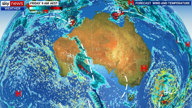
The Bureau of Meteorology’s Angus Hines said the passing weather system, set to hit most major cities by Sunday, will bring a shift in conditions and patchy rain.
“There will be a distinct change in the weather for the southern states during the long weekend as hot, dry and sunny weather shifts to cool, cloudy conditions with patchy showers and the outside chance of thunderstorms,” Mr Hines said.
“Southern Western Australia will already be feeling the cooler winds by Friday, but for South Australia, Victoria and Tasmania, it’s likely to be Sunday when the weather shifts.
“New South Wales and ACT will hold onto the sunny and hot conditions until Monday.
“By the end of the weekend, we should see a shift in conditions from hot, dry weather to cooler and cloudier.”
A lot of places are quite eager for rainfall after quite a dry summer, Mr Hines added.
Good Friday will continue to bring warm temperatures for all of the southeastern parts of the country off the back of a week of summer-like conditions before a cool change settles in.
Sydney will see a top of 29C on Saturday, maintaining balmy temperatures well into the weekend.
Developing showers at the end of the weekend are set to lash the harbour city on Tuesday with up to 20mm expected.
A deep low pressure system in the Tasman Sea will also generate large and powerful surf and swell across the New South Wales coast and offshore islands, including Norfolk and Lord Howe Island.
“This low pressure system is very powerful, although it’s a long way offshore. This low will not impact our weather directly but will generate some very large, powerful waves for eastern Australia,” Mr Hines said.
“These waves will build on Thursday and stay high until Saturday … reaching three to four metres.
“With the weather being clear, bright, sunny and warm, a lot of people will be out and about and thinking about fishing, swimming and taking the boat out. Anyone thinking of heading to the water should check coastal hazard and hazardous surf warnings,” he added.
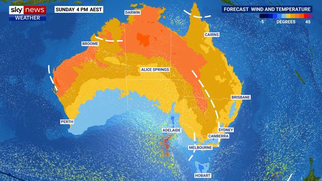
A warm end to the week will have a sudden drop in classic Melbourne style, with a high of 28C on Good Friday dropping to 20C and up to 8mm of rain on Sunday, while Canberra will see light showers near the end of the weekend and the mercury tipped to stay around the mid 20s.
Adelaide is set to feel the brunt of the cool front, hitting a sweltering 30C on Friday before a sudden drop to the low 20s by the weekend with up to 9mm of rainfall.
Showers and temperatures in the mid-to-low 20s are expected well across Easter for Hobart, with a top of 5mm of rain on Sunday.
Meanwhile, Brisbane is expected to miss the weather system entirely with a warm and pleasant week of high 20s to low 30s forecast throughout the long weekend.
Western Australia will also see mostly sunny weather, with temperature fluctuations throughout the 20s and early 30s in Perth.
Severe Tropical Cyclone Errol, currently located 500km off the Kimberley Coast, has strengthened to a category four system in the last few hours and forecasts show it is set to slowly approach land over the next 48 hours.
Mr Hines said it is expected to weaken to a category one by the time it makes landfall, with the most significant weather to hit the towns of Kuri Bay, Troughton Island, Cape Levique, Cockatoo Island and Beagle Bay.
The Easter weekend will be typically warm across most of the Northern Territory, although some cooler than average conditions pushing into the far south as moisture pushes in from the Kimberley.
Darwin looks to miss out on Cyclone Errol’s impacts, sticking a regular top of 33C for the majority of Easter and a top of 9mm of rain on Sunday.


Originally published as Sydney, Melbourne: Cool front brings rain for Easter weekend

Millions facing long weekend washout
Long weekend plans could be under threat across swathes of the country as millions brace for heavy rain and thunderstorms.
Major city rocked by earthquake
People have rushed onto the streets after the city was hit by a 6.2 magnitude earthquake on Wednesday.