
Qld weather: Early weather warning of 100mm daily rain totals
Early weather modelling has suggested one state could be hit with daily totals of up to 100mm a day as a looming rainband intensifies.

Environment
Don't miss out on the headlines from Environment. Followed categories will be added to My News.
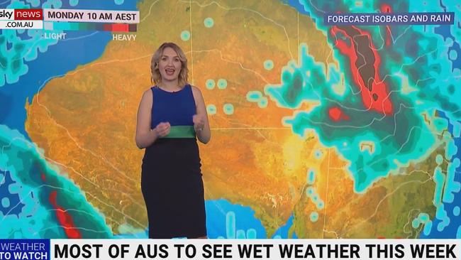
A large-scale rain band is set to reach havoc as it sweeps towards Queensland this week, with some areas in Central Australia forecast to be dumped with “more than a month’s worth of rain” in just days.
Sky News meteorologist, Bradlyn Oaks warned of a possible “unseasonable” deluge of isolated daily totals of up to 150mm in certain parts of the Northern Territory before the rainband hits Queensland from the weekend.
Although Ms Oaks stressed that there was “a lot of model variation here on exactly where the highest accumulation will be”, she forecast stormy conditions and a lot of “wet weather conditions”.
Early weather forecasts show the potential for heavy rainfall in the interior areas of Queensland from Saturday and Sunday before intensifying in the beginning of next week.
Ms Oaks said areas in the eastern part of Queensland could receive daily totals of 100mm.
The Bureau of Meteorology issued another severe weather update on Tuesday.
Meteorologist Miriam Bradbury said “reasonable falls” were recorded, with 70mm in Western Australia’s Fitzroy River catchment and 50mm in Ernabella in South Australia.
Ms Bradbury said the secondary rainband would likely intensify from Friday onwards, “pushing back into the Kimberleys,” while also “potentially bringing impacts to the north tropical coast (in Queensland) through the early part of next week as well”.
“We’re not necessarily expecting downbursts of heavy to intense rainfall with this system, it’s more going to be steady rain that accumulates over hours or days,” she said.
“What makes this system significant is the duration of the event, stretching all the way through the weekend, and the extensive rainfall across the country.
“It’s expected to have widespread impact on roads and access routes with potential flooding.”
Severe Weather Update: Weather forecast. Find out what to expect across the country over the coming days. Video current at 1:00pm ACST, Tuesday 27 June 2023. Latest: https://t.co/4W35o8iFmh or the BOM Weather app. pic.twitter.com/nlhvYeRs4I
— Bureau of Meteorology, Australia (@BOM_au) June 27, 2023
South of the border, NSW could also expect patches of intermittent rain.
The bureau has forecast a shower or two for Sydney on Wednesday (up to 7mm) and Thursday (up to 3mm).
Showers were also expected on Monday and Tuesday, with rainfall totals of up to 10mm.
In Perth, temperatures plummeted to just 0.7C on Tuesday morning, with the capital city reporting its coldest morning since June 13, 2016.
Just sightly more inland, Perth airport reported temperatures of -0.6C, the coldest morning since July 25, 2012.
A frosty start for #Perth metro this morning!
— Bureau of Meteorology, Western Australia (@BOM_WA) June 26, 2023
🥶 Just 0.7°C at 6.47am, our coldest morning since 13 June 2016 when we recorded 0.6°C
âœˆï¸ At the Airport, a chilly -0.6°C, the coldest morning since 25 July 2012
â˜€ï¸ Warming up to 17°C today
Observations: https://t.co/ijPnuJlZaXpic.twitter.com/0Pdnyknhbp
South Australians continue to be under “watch and act” orders from the State Emergency Service.
The bureau has issued a flood watch alert for parts of the Flinders, North West and North East Pastoral districts, with fears the rain could intensify throughout Tuesday before contracting on Wednesday.
Affected catchments include Flinders Ranges rivers and creeks, the Simpson Desert, Lake Eyre, Warburton River, Finke River and Stephenson Creek, Eastern Great Victoria Desert, and Warburton District Rivers.
While catchments were dry ahead of the rainfall, the bureau warned there might be rises in local creeks and over-bank flooding, with roads likely affected.
Originally published as Qld weather: Early weather warning of 100mm daily rain totals
Cyclone less than 24hrs away from Aus
A tropical low sitting off the east coast of Australia is less than 24 hours from forming into a category 2 tropical cyclone – and could make its way towards millions.

‘Extreme’ danger warning as temps soar
Millions of Aussies bracing for blistering temperatures this weekend, with the extreme conditions sparking several warnings.