
Mapped: NSW suburbs most at risk of bushfires
Ahead of a hot and dry summer, the areas at increased risk of bushfire have been revealed. Take a look at these exclusive interactive maps to see whether your suburb is in danger.
Exclusive: The eastern states are copping a drenching right now, but hot and dry conditions over summer are expected to put many regions at elevated risk of bushfire, including those that burnt during the Black Summer, the latest seasonal outlook shows.
The summer outlook from AFAC, the national council for fire and emergency services, reveals there is increased risk of bushfire for large areas of Queensland, NSW, and NT, as well as smaller regions in Victoria, SA, WA and Tasmania.
“Abundant vegetation growth supported by previous La Niña rainfall will continue to dry throughout summer, increasing the flammability of fuel loads. This includes some areas burnt during 2019-20 season,” the outlook warned.

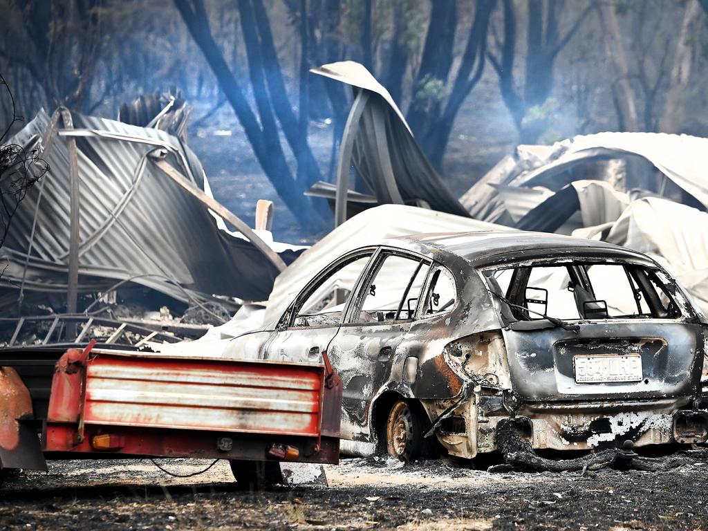
The full force of bushfire season has already arrived in some parts of the country. Eighteen homes were lost and more damaged by blazes north of Perth this month, while in October two people died and some 50 homes were destroyed in Queensland (making it a worst disaster for the state than the Black Summer). Crews also battled fierce bushfires near Grafton and Tenterfield in NSW.
According to the Bureau of Meteorology, Australia as a whole experienced its driest September on record (since 1900), and its fifth driest October.
The Bureau has forecast below average rainfall for summer across most of northeast Australia and the northern coastline, while above-average maximum and minimum temperatures are “very likely … for almost all of Australia” – meaning both hot days and nights.
Thursday’s outlook comes as new research shows the poorest 30 per cent of Australian communities are most at risk of bushfire.
Dr Sonia Akter and Professor Quentin Grafton from ANU analysed data from the Black Summer and found the link between lower socio-economic status and bushfire destruction was most strong in NSW and Victoria.
Poorer communities “are less able to invest in prevention and firefighting equipment and/or to train volunteer firefighters. As a result, their fire hazard reduction and fire suppression may have been less effective than in better off areas,” the researchers said.


People in those areas were unable to spend the estimated extra $100,000 to build a fireproof family home, or the minimum $14,000 needed for fireproof bunkers, Dr Akter and Prof Grafton said.
“Local governments where poor communities are located should receive more per capita support from governments for carrying out their obligations of managing bushfire
risks,” the researchers stated.
BUSHFIRE RISK IN YOUR SUBURB
A new tool launched by 360 info at Monash University shows Australians the bushfire risk in their own suburbs.
Shared exclusively here, these interactive tools – drawn from the bushfire risk area maps maintained by state and territory governments – reveals the sometimes huge disparities in bushfire risk that can exist in areas that are very close together.
In Western Sydney, for example, 16 per cent of Mt Druitt is rated as a bushfire risk, whereas in neighbouring St Marys the proportion is 32 per cent.
Likewise in Victoria, Colac, west of Geelong, 16 per cent of the area is regarded as being at risk, but it Colac West that increases to 97 per cent.

In the following maps, the suburbs in brown have a high percentage of areas that are deemed at risk of a bushfire, while yellow ones only have a small percentage, or none at all. Not having areas deemed at risk doesn’t mean that a bushfire is impossible, just that there is less risk.
NEW SOUTH WALES
Large areas of eastern, central and northern NSW, and almost the entire length of the coast, have been rated as having an increased fire risk in the 2023/24 summer in the AFAC Bushfire Outlook.
The far west, parts of the south and the Australian Capital Territory have all been rated as having normal bushfire risk for the season.
The outlook warned that large parts of NSW are “much drier than normal”, and there is the potential for much quicker evaporation due to higher expected temperatures.
Fire agencies warned that areas that burned during the Black Summer were at risk once again.
“Forested areas burnt during Black Summer (have) regrown rapidly to the point where they are able to carry fast moving and dangerous bushfires. The speed of this recovery is unusual. Typically, areas burnt this recently would slow or limit the spread of new fires,” the Outlook stated.
VICTORIA
A large area to the west of Melbourne, stretching from Ballarat to the surf coast, and the region to the east of Bairnsdale have been assessed as having an increased risk of bushfire in the 2023/24 summer outlook.
Areas that did not burn during the Black Summer, or burned only lightly, had the highest potential risk, emergency services warned.
Significantly lower rainfall in winter and spring meant areas in eastern, western and central Victoria all had above-average fire potential, but tall, damp forested areas were rated as having lower potential due to underlying moisture and abundant green growth.
QUEENSLAND
Already hit hard by bushfires during Spring, almost all areas of Queensland except for the southwest shoulder around Birdsville are at elevated risk of fire during the 2023/24 summer, AFAC warned in the outlook report.
A long and difficult season could be in store for Queenslanders.
“The continuation of below average rainfall, elevated fuel growth and lowest on record rainfall deficiencies across southern parts of Queensland throughout the late winter and spring months, has primed many parts of the state for an extended fire season,” the report stated.
A protracted fire season was likely around the North Tropical Coast, but a waning El Nino influence could see “a return to normal rainfall patterns across central and southern Queensland” in later summer.
SOUTH AUSTRALIA
A large area to the north and east of Adelaide – reaching as far as Port Augusta and almost to the Victorian border – is the area of the state deemed at highest risk of fire in the 2023/24 bushfire outlook.
But the report also warned of the likelihood for a longer fire danger season, and “above average” fuel dryness across most of the state, driven by the highest temperatures on record.
“In contrast to recent years, 2023 has seen an earlier and more rapid switch to dry conditions leading into summer,” the outlook warned.
WESTERN AUSTRALIA
The bushfire outlook report identified several areas in the West to be at increased bushfire risk during the 2023/24 summer.
A section of coast stretching from Jurien Bay to east of Albany, taking in Perth, Bunbury and the Margaret River will be of particular concern, while other population centres at elevated risk include Esperance, Broome and Onslow.
The northern rainfall onset for the Kimberley and Pilbara regions is expected to be later than normal due to the influence of El Nino, the outlook warned, potentially lengthening the bushfire season in these areas.
In the southern part of the state, “existing rainfall definiciences and warmer than average conditions will likely contribute to above average fire danger for forest and shrub land areas,” the outlook stated.
NORTHERN TERRITORY
A large swath of the Northern Territory has been assessed as having increased fire risk in the 2023/24 AFAC summer outlook.
While the Top End, Katherine and Arnhem districts are thought to have normal fire potential, the danger is in the central Australia and Barkly regions, where grass fuel loads are high.
Agencies warned resourcing for “suppression and response” was stretched thin in these areas.
“Dry lightning has caused multiple ignitions and an above normal fire potential is predicted for the Barkly, Tanami, Alice Springs and Lassiter regions,” there Outlook warned. “Landholders need to be vigilant of weather conditions, ensure they are adequately prepared, and have fire breaks strategically installed throughout their properties.”
TASMANIA
Areas north of Hobart, stretching into the centre, have been assessed as having increased fire risk in the 2023/24 AFAC summer outlook.
“Areas of the Midlands, East Coast and South East are now significantly drier than normal, indicating drier bushfire fuels more generally,” the report stated.
With lower than normal rainfall forecast for summer, emergency services expressed concern the drying of fuel loads would continue, leading to increased fire risk in the Northern Midlands and the Fingal and Royal George valleys in early 2024.
More Coverage
Originally published as Mapped: NSW suburbs most at risk of bushfires
Join the conversation

‘Disrespect’: Libs blasted for net zero move
Read more

Tarzia goes Speirs fishing in $30m algal bloom rescue plan
Read more