
Fresh band of moisture set to bring ‘huge’ amounts of rain to east
It’s already wet in the east. Now a new weather threat is on the horizon that could bring a month’s rain in just a few days and flash flooding.

Huge areas of the east are already sodden with warnings of flash flooding in place for parts of central Queensland.
Now forecasters have warned a second band of heavy rain is creeping from west to east across the country that could extend the deluge and deliver more flooding in the week to come.
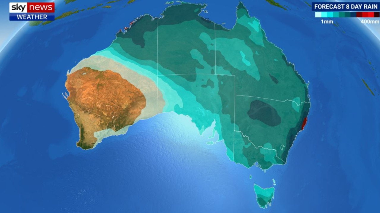
Some locations could see three times’ March’s rainfall descend in just a few days. It’s almost certain that most parts of the NSW coast and into southern Queensland will at least surpass their average monthly rain in the coming week.
“Huge amounts of rain could fall over the next eight days,” Sky News Weather senior meteorologist Tom Saunders said.
However, in Western Australia, it’s not rain but hot weather on the cards with a low-intensity heatwave over Perth upping temperatures well into the thirties.
On Wednesday morning, some Queensland residents were told to move to higher ground after towns in central parts of the state received more than 130mm in three hours overnight.
An emergency alert was issued by the Central Highlands Regional Council for residents in Sapphire, northwest of Emerald, shortly before 5am, urging residents in low-lying areas to move to higher ground immediately.
More than 215mm of rain fell in the Gemfields overnight, with Retreat Creek rising 9m in just four hours. Nearby, Clermont recorded 129mm of rain, it’s heaviest in two years.
“This rain is being caused by a strong high to the east of Tasmania. Winds blow anticlockwise around highs and as a result of very humid easterly from the Tasman Sea and the Coral Sea, that’s pumping moisture into this trough line over the east, and that’s what’s causing the rain,” Mr Saunders said.
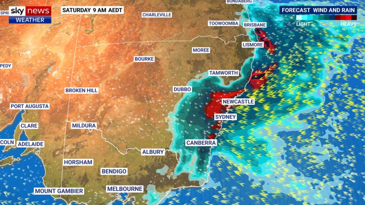
Over the next few days the intensity of the rain should ease a touch over Queensland. Some of the heavier falls should then move south towards northern and mid-coast NSW where up to 200mm could fall over the next six days.
That’s more than enough for localised flash flooding. Some of that heavy rain is also likely to find its way down to Sydney.
NEW RAIN BAND SET TO APPROACH
The system causing the incessant rain is already in place. But looking ahead a new moisture monster is approaching. It looks like the rain just isn’t going to cease.
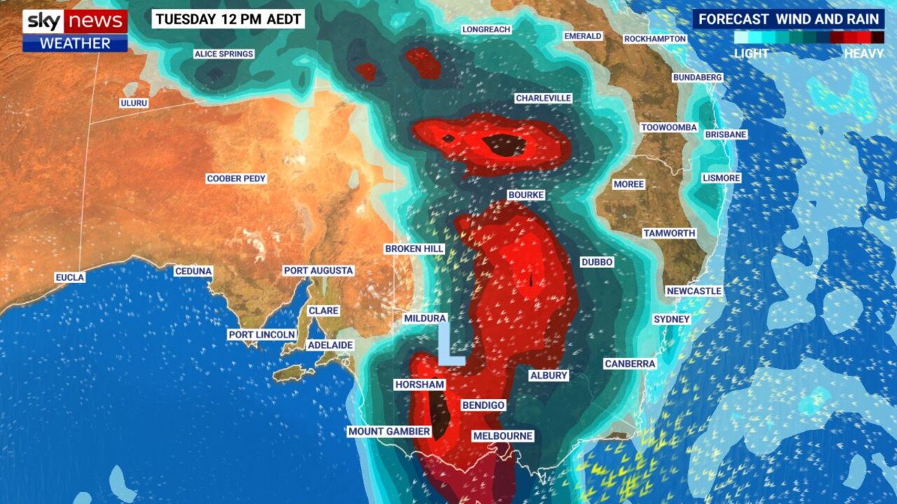
“A second bout of rain is starting to move across the interior,” Mr Saunders said.
“It will arrive early next week bringing widespread heavy rain potentially spreading through the southeast inland around him Murray Darling Basin.
“Over the next eight days that could bring over 50mm to north west NSW and south east Queensland, with 200mm for the NSW coast and Sydney likely to see around 100mm of rain.”
If Sydney does pick up 100mm in the next week that will be just shy of its 132mm March monthly average rain. However, Sydney has already recorded 87mm in the gauge this month, so by next week it could have exceeded the usual March rain total by a substantial margin with a week to spare.
Port Macquarie’s expected 200mm would easily push past March’s usual 175mm. While Cobar, south of Bourke and deep into central NSW, could pick up 100mm of rain in the coming week, three times the average. That amount of rain will mean flooding is a real risk.
Downpours are almost a certainty every day in Sydney for the coming week with particularly high falls from Thursday to Saturday when up to 50mm could fill the gauge in a single day. Highs will be in the mid-twenties.
It’s much the same rain outlook for Brisbane with up to 20mm today. However, later in the week the precipitation should lessen with the rain concentred in showers. The mercury will edge towards 30C as the week goes on.
There will be some rain in Canberra over the next few days but it could get heavy from Saturday when 15mm may fall on the capital. That will set a pattern into next week. Maximum temperatures will hover around 20C.
Northern Australia is also looking like it will get some decent falls of between 25-50mm.
Very heavy rain is expected in Darwin on a warm 30C Wednesday when up to 30mm could fall.
Following that, 10mm each day won’t be a rarity. West of Darwin near the coast, towards Kununurra, heavier downpours are forecast.
However, in much of the rest of Western Australia, heat is the main play. Perth will top out a 31C today but its set to rise to a sunny 38C by Friday as a heatwave kicks in.
It will be mostly sunny in Adelaide with highs touching 30C. Very little rain should reach populated areas of South Australia.
Similarly, Melbourne should remain mostly dry into the weekend but cloudy with maximums of around 25C. However, some heavier falls are on the radar for early next week.
Some sun between the clouds in Hobart with highs in the mid-twenties but umbrellas will likely not be needed.
Originally published as Fresh band of moisture set to bring ‘huge’ amounts of rain to east

BOM grilled over ‘nightmare’ $96m website
