Emergency flood alert for Sapphire, central Qld after 130mm of rain in three hours
Residents in some low-lying areas of Queensland have been told to ‘move to higher ground now’ after more than 130mm of rain fell in three hours overnight.

Environment
Don't miss out on the headlines from Environment. Followed categories will be added to My News.
Some Queensland residents have been told to move to higher ground “now” after towns in central parts of the state received more than 130mm in three hours overnight.
An emergency alert was issued by the Central Highlands Regional Council for residents in Sapphire, northwest of Emerald shortly before 5am, urging residents in low-lying areas to move to higher ground immediately.
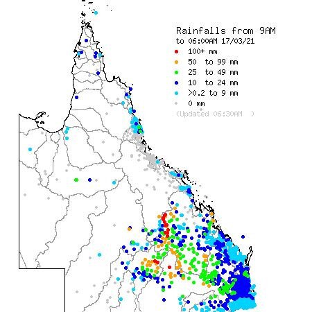
More than 215 mm of rain fell in the Gem Fields overnight, with the river height of Retreat Creek at Sapphire reaching 10m, exceeding the major flood level within a matter of hours.
Severe thunderstorms with heavy rainfall across the Gem Fields #Queensland overnight saw up to 215mm of rain and river height rises at #sapphire to nearly 10m in a few hours reaching major flood level. Know your weather. Know your risks. https://t.co/rLTVafQGKjpic.twitter.com/aVpHDdRkz0
— Bureau of Meteorology, Australia (@BOM_au) March 16, 2021
“Due to heavy rainfall, the Retreat Creek is rising rapidly and major flooding is expected,” the alert from Queensland Fire and Emergency Services said.
“Properties in low-lying areas are likely to be impacted. Council advises residents to warn neighbours, secure belongings and move to higher ground now.”
It comes after severe thunderstorms lashed the Central Highlands overnight.
In the latest advice from the Bureau of Meteorology at 6am, they said the immediate threat had passed.
Florence Vale, west of Emerald, received 124mm in the three hours to 1.40am on Wednesday morning, while nearby Keilambete recorded 138mm in the three hours to 12.35am.
Flood warnings are also current for the Upper Warrego River, Paroo River, the Bulloo River and the Diamantina River.

It comes as new climate modelling suggests La Nina’s influence is likely to persist into April.
“Outlooks indicate a wetter-than-average month for northern and eastern parts of Australia,” the Bureau said.
New South Wales and Queensland are in for a wet and stormy week, with chances of rain in the blue state above 70 per cent for six straight days.
Meteorologist Helen Reid said the rain would get more intense in NSW from Wednesday, as a high pressure system near Tasmania extends a ridge across eastern parts of NSW.
In Queensland, a very high chance of showers is predicted for the state’s coastline until Sunday as an inland trough extends across interior districts, and is expected to remain stationary through the week.
Got your umbrella? Large parts of Queensland can expect wet conditions over the coming days. Full details: https://t.co/arg42NTen0pic.twitter.com/544sekYt2j
— Bureau of Meteorology, Queensland (@BOM_Qld) March 16, 2021
National Wednesday forecast
Sydney: Cloudy, with a high chance of showers throughout the day, maximum of 22C. Surf conditions may be more powerful than they appear, and are expected to be hazardous for coastal activities.
Melbourne: Mostly sunny, with the chance of early fog in the morning. Maximum of 26C.
Brisbane: Cloudy, with a very high chance of rain, maximum of 24C.
Perth: Sunny, maximum of 31C.
Adelaide: Sunny, maximum of 29C.
Hobart: Mostly sunny, maximum of 23C.
Canberra: Cloudly, slight chance of a shower and maximum of 19C.
Darwin: Showers and possible storm later in the day, maximum of 31C.
Originally published as Emergency flood alert for Sapphire, central Qld after 130mm of rain in three hours


