Dire warning of flash flooding, isolated 250mm falls for NSW as state braces for wild deluge
Australia’s east coast is bracing for a wild deluge which could dump up to 250mm in some regions and possibly leave thousands exposed to flash flooding.
Environment
Don't miss out on the headlines from Environment. Followed categories will be added to My News.
NSW could be smashed with isolated showers of up to 250mm as a massive deluge bears down the east coast, which the Bureau of Meteorology says could lead to flash flooding for thousands.
Much of the east and west coast of Australia were smashed last week with a 5000km rain band – dumping up to 157mm of rainfall in some areas.
But the Bureau of Meteorology (BOM) forecasts there may be no relief for NSW or Perth, along with some parts of Victoria, in the coming days and even into the weekend.
“Significant weather will be impacting the far west and the far east of the country through the second half of this week,” BOM meteorologist Angus Hines said.

“Lots of clear skies through Australia in the far northern parts of the country and in the centre, the action happening in terms of rainfall is happening in New South Wales, as well as far south west of WA.
“The wet weather will kick off in both of those regions late on Thursday and it is expected to be quite wet on both edges of the country through Friday.”
By Friday, parts of north eastern Victoria will feeling the downpour.
Mr Hines also outlined that across the three days, the Bureau is forecasting up to triple digits of rainfall to hit.
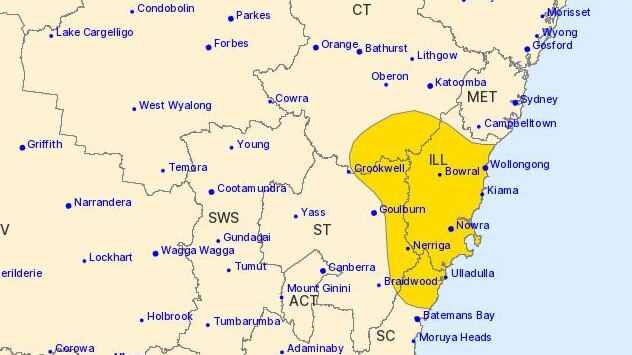
“A hundred millimetres of rain, if not more around the Illawarra and the south coast district. And because of that incoming heavy rainfall, we have issued a severe weather warning,” he said.
Due to the expected heavy rainfall, the BOM have issued flood warnings for parts of the Sydney metro area, Illawarra and the central and south coasts of NSW.
“A trough is expected to develop off the south coast during Wednesday and deepen into a coastal low during Thursday,” the BOM outlined.

“This is likely to bring areas of very heavy rainfall and flooding across the southern parts of The Central Coast, Sydney metropolitan area, Illawarra, northern parts of the south coast and the adjacent ranges.”
Particular rivers on flood watch are the Upper Nepean River, Hawkesbury and Lower Nepean Rivers, Colo River, Georges and Woronora Rinvers for moderate flooding.
Rivers predicted for minor flooding include the Cooks River, Shoalhaven River, St Georges Basin, the Moruya and Deua Rivers.
Along with rain, the Bureau has outlined cooler temperatures across the states as we finish off the first week of winter.
Minimum temperatures in northern parts of Australia, with Darwin hitting 17C, Townsville at 14C and Alice Springs at 3C on Friday morning.

New South Wales
A flood watch has been issued for parts of The Central Coast, Sydney metro area, Illawarra and the south coast.
The BOM has forecasted moderate flooding likely to be in the Hawkesbury Nepean Valley and the Georges River from Thursday. Widespread rainfall between 100-150mm with some places expected to get up to 250mm from Thursday to Friday.
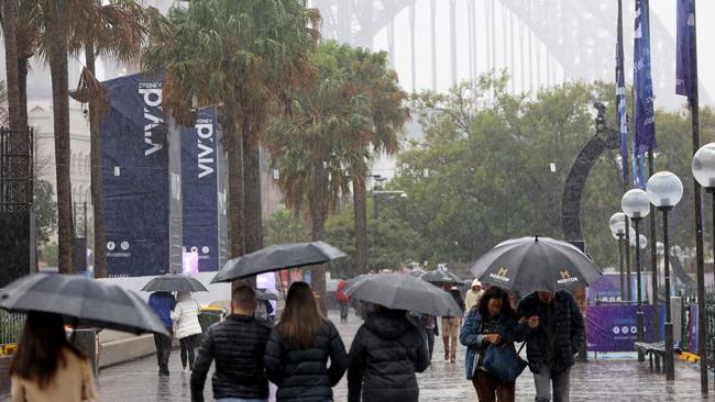
A cloudy and possible chances of rain for Sydney on Thursday, with a maximum temperature of 18 and a low of 12.
Victoria
No weather warnings are currently in place for the state.
Melbourne area is expected to be cloudy on Thursday, slight chance of showers in the northwest suburbs and light winds in the south. Maximum temperature of 17 with a low of 8.
Queensland
No weather warnings are currently in place for the state.
A sunny day for the Brisbane area, with a chance of morning fog. Maximum temperature of 23 with a low of 11.
Western Australia
The BOM have issued gale warnings for the Leeuwin Coast, with strong winds expected to be in Perth Local Waters, Geraldton Coast, Lancelin Coast, Perth Coast, Bunbury Geographe Coast, Albany Coast and Esperance Coast.
Cloudy and high chance of rain and thunderstorms in the Perth area, with a maximum temperature of 23 and a low of 12.

South Australia
No weather warnings are currently in place for the state.
A mostly cloudy morning is expected for the Adelaide area, with chances of morning fog in the northern suburbs. Slight chance of showers in the hills and the southern suburbs with a maximum temperature of 18 and a low of 8.
Tasmania
Minor flood warnings are in place for the South Esk River at Fingal and the St Pauls River.
Light winds and a cloudy day is forecasted for the Hobart area on Thursday, with a maximum temperature of 15 and a low of 8.
Australian Capital Territory
A flood watch has been issued for parts of The Central Coast, Sydney metro area, Illawarra and the south coast.
A cloudy and rainy morning and afternoon for the Canberra area, with a maximum temperature high of 15 and a low of 5 for Thursday.
Originally published as Dire warning of flash flooding, isolated 250mm falls for NSW as state braces for wild deluge


