
Coming months set to be hotter and drier as El Nino warnings grow
La Nina has just ended, but it’s already feeling very El Nino as a heatwave hits. And there are warnings of “supercharged” bushfires to come.

Environment
Don't miss out on the headlines from Environment. Followed categories will be added to My News.
La Nina has left the building – and its absence is already being felt as temperatures rise.
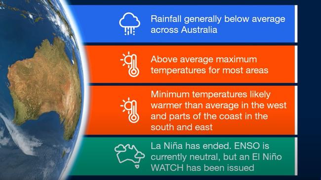
The Bureau of Meteorology (BOM) is warning the next three months will see below-average rain while it’s also “very likely” to be hotter than usual across much of Australia.
And with a possible El Nino just around the corner, that raises fears of “supercharged” bushfires.
The BOM’s climate outlook comes as eastern Australia gets set for heatwave weather across the weekend. Western Sydney may scrape 40C with Melbourne reaching 37C.
“It’s going to be a hot one in NSW with temperatures rising into the mid-thirties all the way to the coast,” Sky News Weather meteorologist Rob Sharpe said.
“This will be up there as some of the worst heat we’ve seen in Sydney, Wollongong and Newcastle and surrounds over the past season.”
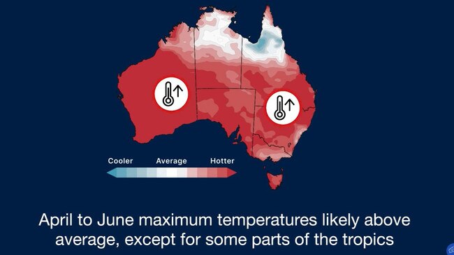
It could be a taste of things to come. The Bureau’s climate outlook for April to June, published on Thursday, is very different to previous months when it’s all been about moisture and possible flooding.
Now it’s the opposite.
“Rainfall for April to June is likely to be below average for most of Australia,” the BOM said.
“Maximum temperatures during April to June are likely to be warmer than average for most of Australia, except for some parts of the tropics.”
Overnight lows won’t be as low either, particularly in Western Australia, the south and east.
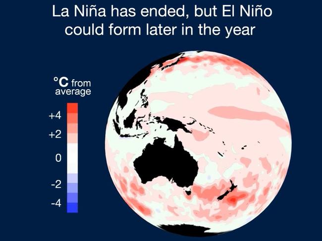
Just this week, the BOM declared La Nina was done, after three long and very soggy years.
“La Nina has ended and the El Nino Southern Oscillation (ENSO) is now in neutral. However, there are some signs that El Nino could form later in the year,” the BOM said in its climate outlook.
It has issued an El Nino “watch” – meaning it is betting that the ENSO climate driver will fully flip, leading to a drier and warmer spell, particularly for Australia’s east.
‘Supercharged’ bush fire season warming
The prolonged La Nina has aided plant growth and lessened the number of bushfires to consume it. That means there’s now plenty of fuel to burn.
The Climate Council, an independent think tank which campaigns for Australia to reach net zero emissions, released a report last month warning this year could be nasty one when it comes to fires.
“History shows that grass fires follow floods,” the report said.
“Firefighters fear that the spring of 2023 and summer of 2023-2024 could see widespread grass fires, supercharged by climate change.”
The Climate Council said each of the prolonged La Nina events since 1950 were followed by “extensive” and deadly grass fires on the east coast, with focus on NSW.
“Governments must prepare for a potentially devastating fire season ahead.”
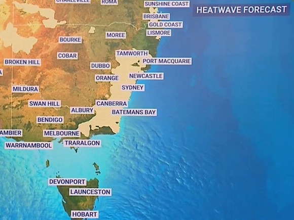
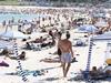
Heatwave this weekend
If you need to get in the mood for the coming months look no further than this weekend.
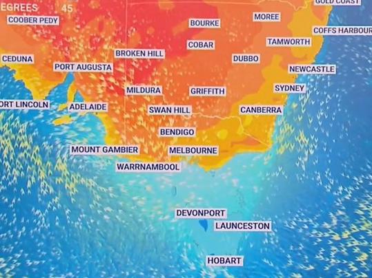
A low-intensity heatwave has spread across Central Australia and over the weekend will likely envelop much of the NSW coast as well as Canberra and Brisbane.
Heatwaves are defined as three or more days of unusually high maximum and minimum temperatures.
“Northerlies will gather strength in western parts of South Australia on Friday, and then into Saturday morning it’s going to remain warm in Adelaide,” Mr Sharpe said.
“Then the heat is on for NSW and into Victoria on Saturday. Melbourne may even hit the mid-thirties.
“The threat of extreme fire danger is a possibility in parts of southeastern Australia.”
However, cooler conditions will move through by Monday, extinguishing the heatwave.
Adelaide is set to hit 31C on Friday, dropping to 29C highs on Saturday and 25C on Sunday.
Melbourne will see a huge jump in the mercury from a mere 24C on Friday to 37C on a windy Saturday. Then by Sunday it’s down to 21C with a few showers.
Hobart will also see a heat peak with maximums of 20C on Friday and Sunday but 26C on Saturday.
Canberra will be staying just below 30C on Friday, then creeping up to 32C on Saturday before it tops out at 36C on Sunday with an 11 degree drop in the maximum temperature on Monday.
Sydney’s CBD will sit around 30C for the coming days with Sunday likely the hottest at 32C. On Monday expect showers and 25C.
As ever, it will be warmer in the west of Sydney, with Penrith peaking at 39C on a blistering Sunday.
Newcastle can expect 35C to round off the weekend and Wollongong 32C.
Mostly sunny in Brisbane with Friday the warmest at 36C and then 32C for both Saturday and Sunday.
Some rain is possible in northern Queensland chiefly on Sunday where up to 20mm could fall in Cairns. Temperatures will hover about the 30C mark.
Stormy in Darwin with some rain and 33C highs for the coming days.
Perth will be relatively mild for Friday and Saturday getting into the mid to high twenties but 33C is forecast for Sunday and then 36C on Monday.
Originally published as Coming months set to be hotter and drier as El Nino warnings grow

Millions brace for brutal cold snap
Residents in the southern part of Australia should rug up extra warm this weekend as a cold snap settles in, bringing lashings of rain and damaging wind.

Delays as Bali flights resume after volcanic eruption
A volcanic eruption in Indonesia has disrupted travel for more than 14,000 passengers with delays and backlogs still expected.