
Townsville cyclone: Kirrily on track to North Qld as BOM releases latest forecast
Tropical Cyclone Kirrily is still on track to cross the coast at Townsville later tonight, as the Whitsundays starts to feel gales and damaging winds from the strengthening system.

Townsville
Don't miss out on the headlines from Townsville. Followed categories will be added to My News.
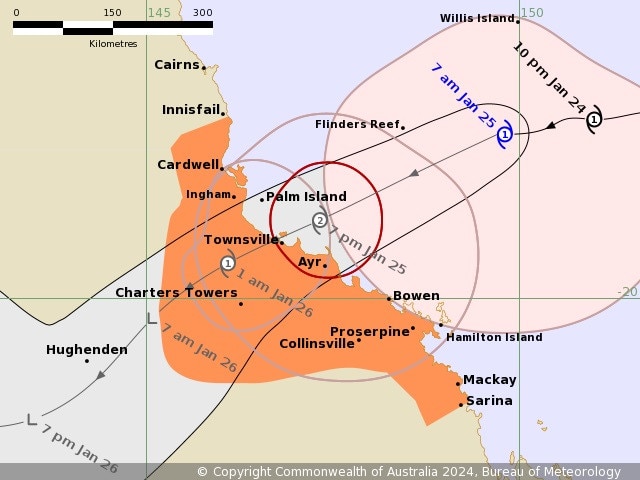
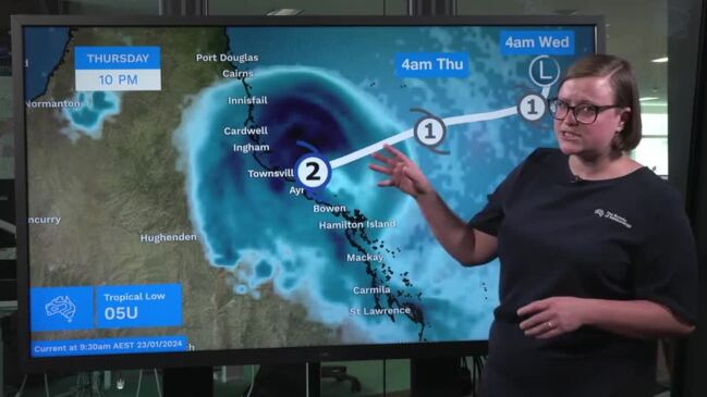
8AM THURSDAY: Tropical Cyclone Kirrily is still on track to cross the coast at Townsville later tonight, as the Whitsundays starts to feel gales and damaging winds from the strengthening system.
The tropical low officially became a cyclone yesterday afternoon, and the expected point of landfall tonight has been tightened to ‘in the vicinity of Townsville’.
In the Bureau of Meteorology’s Thursday 8am update, the service says the Whitsundays are already experiencing gales and damaging winds up to 125km/h.
Those winds are expected to extend to the areas between Ayr and Sarina this morning.
Flash flooding is likely along coastal areas between Innisfail and Sarina from this morning, extending inland this afternoon, overnight and Friday.
The intense rain likely means dangerous and life-threatening flash flooding near the track of the system, which the latest forecast predicts to be over the northern edge of Townsville.
The category 1 cyclone has picked up speed and now sits about 360km east northeast of Townsville, travelling about 19km/h.
The weather system is tracking to become a category 2 tropical cyclone by 7pm when it nears the coast at Townsville tonight.
5PM WEDNESDAY: Tropical Cyclone Kirrily has officially been named, with the system intensifying into a Category 1 system and its latest forecast track moving further north.
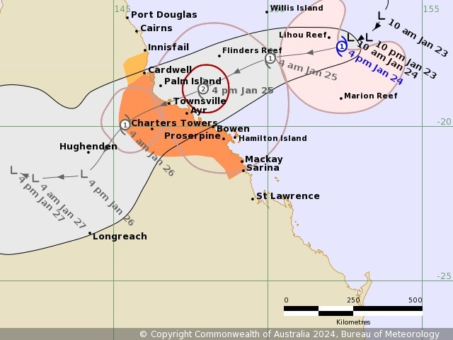
As of 4pm Wednesday, TC Kirrily was estimated to be 630km east northeast of Townsville and 530 km northeast of Mackay.
“Tropical Cyclone Kirrily has developed in the central Coral Sea, and is expected to continue strengthening as it tracks west southwest towards the Queensland coast,” BOM’s 5pm update reads.
“The system is likely to cross the Queensland coast Thursday night between Cardwell and Bowen as a Category 2 system. In the longer term, the system is likely to track further inland as a tropical low, bringing heavy to intense rain to parts of the northern interior and western Queensland.”
Prepare for isolation
Communities of Cungulla, Saunders Beach and Gumlow have been warned to prepare for damaging winds, heavy rain and flooding as a soon-to-be-named tropical cyclone moves closer.
>> North Queensland prepares: In photos
Townsville’s Local Disaster Management Group issued a ‘prepare for isolation: watch and act’ alert for the three communities at 12.15pm Wednesday.
“The rapidly forming low in the Coral Sea will form into a cyclone and is going to cause severe impacts through damaging winds, heavy rain and flooding,” the update read.
“The cyclone’s projected path and intensity require swift and decisive preparedness actions.
“Residents in these areas must be prepared for isolation. If residents are not prepared for isolation, they must be prepared to leave.
“Voluntary evacuations are recommended for at-risk homes in Cungulla, Saunders Beach and Gumlow.”
Police have been out doorknocking in Cungulla, Saunders Beach and Gumlow asking at risk residents in low-lying areas to heed their advice and move if possible as evacuation centres open their doors.
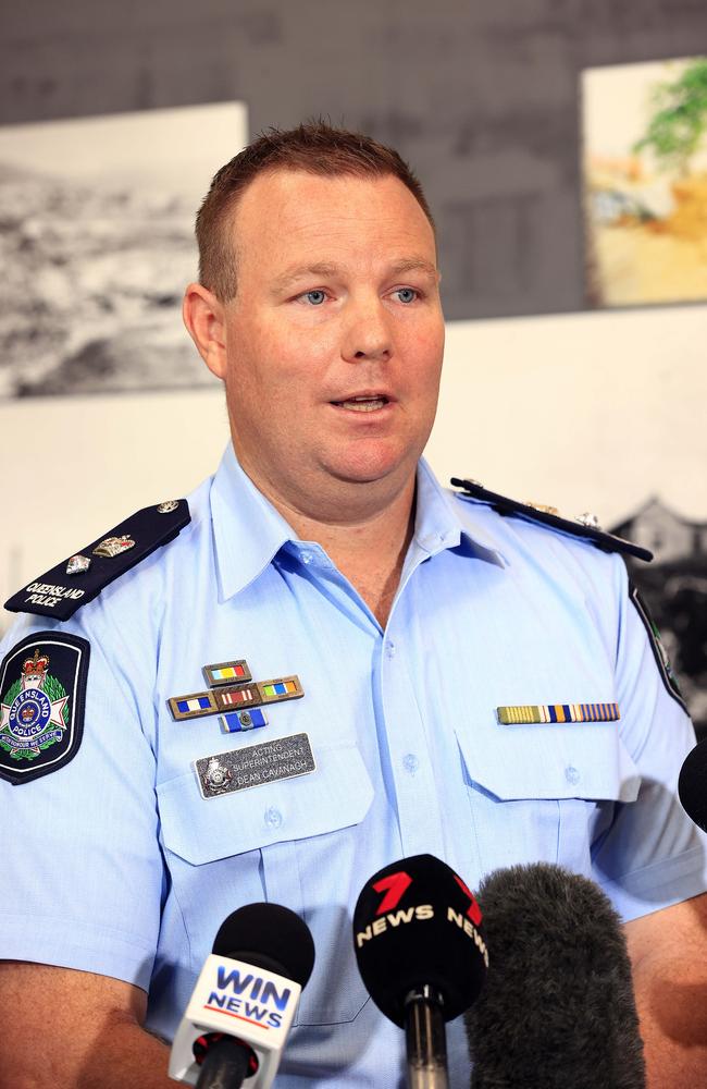
Acting Superintendent Dean Cavanagh said police had been out doorknocking in the Cungulla, Saunders Beach and Gumlow to ensure residents were well prepared.
He said officers may advise voluntary evacuations for some at-risk homes or residents with health concerns who may be at risk if their area becomes isolated by flood waters.
“It’s to get the message out there that if people deem themselves or their houses are at risk, please move out of those low-lying areas and areas that potentially could be isolated if this weather event continues,” he said.
“Please heed their advice, talk to the officers. They’re out there trying to keep you safe.
“Any advice they do have, please consider that and move with family and friends if possible.”
People who find it hard to move quickly should consider leaving now.
If your life is in danger, call Triple Zero (000) immediately.
For cyclone help, call the SES on 132 500.
Superintendent Cavanagh said they had also pre-deployed additional police commanders, officers and multiple vehicles to various locations, including Ingham, Ayr, Charters Towers and Palm Island.
“We’re just trying to be really well prepared,” he said.
He reiterated the importance of safety on the roads in the event of possible flooding and strong winds causing debris to fall on the roadway.
“It’s a really important message that if you need to drive on the roads, take as much care as you can, and please remember, if it’s flooded, forget it,” he said.
Evacuation centres activated
The LMDG says voluntary evacuations are in effect, targeting properties at risk. If you think your property is at risk of not withstanding a Category 2 Tropical Cyclone, then you should prepare to leave. Families are encouraged to seek shelter with relatives or use designated shelters/places of refuge.
If your home is not a safe place and you have no other options, there are evacuation centres open from 1pm on Wednesday 24 January at:
- Heatley Secondary College, 321 Fulham Road, Heatley
- Wills Street Evacuation Centre, Townsville City
Airport closure
Townsville Airport will be closed from noon on Thursday, with airlines changing their flight schedules tonight and tomorrow.

General manager Brendan Cook said people needed to be aware of the changes to their flights if they were expecting to fly on Wednesday, Thursday or Friday.
“At this point, the airport will be closed from midday tomorrow in preparation for gale force winds Thursday afternoon,” he said.
“The airport team will come back to the airport on Friday morning when it is safe to do so. (This is) to assess the condition of the airfield and reinstate operations as soon as possible.”
Mr Cook said dismantling an airport was a “big job”, with a lot of things to take apart.
“Then a lot of things are assessed before we can reinstate an airfield,” he said.
“Hopefully the winds die down Friday morning and we can get some teams on site early in the morning and maybe reinstate operations by early afternoon.”
Schools close ahead of cyclone
Dozens of public schools across the Townsville, Hinchinbrook and Burdekin regions will be closed on Thursday ahead of Cyclone Kirrily.
>> See the full list of closures here
Townsville Catholic Education will also temporarily close several Catholic schools along the coast of Queensland on Thursday.
It is expected that students will return to school next Monday, 29 January, unless updated communications are received.
In Townsville, the following schools will be closed: Good Shepherd Catholic School, Holy Spirit Catholic School, Ignatius Park College, Marian Catholic School, Ryan Catholic College, Southern Cross Catholic College, St Anthony’s Catholic College, St Benedict’s Catholic School, St Clare’s Catholic School, St Joseph’s Catholic School (The Strand), St Joseph’s Catholic School (Mundingburra), St Margaret Mary’s College and St Patrick’s College.
In Hinchinbrook, Gilroy Santa Maria College, Our Lady of Lourdes Catholic School, St Peter’s Catholic School and St Teresa’s College will also be closed.
On Palm Island, St Michael’s Catholic School will close along with Burdekin schools, Burdekin Catholic High School, St Francis Catholic School and St Colman’s Catholic School.
Columba Catholic College in Charters Towers will also be impacted along with Whitsundays schools, St Catherine’s Catholic College, St John Bosco Catholic School and St Mary’s Catholic School.
The Department of Education said on Wednesday that the safety of its students and staff was its top priority.
“The department’s school closures website provides communities with the most up-to-date information about the status of schools in areas affected by significant weather events,” it said on Wednesday afternoon.
“The website will reflect any impacts to learning and can be accessed at closures.qld.edu.au.)
The department said it and individual schools would keep communities updated as the situation changes.
“Parents, families and children are urged to not take risks, and be especially cautious around floodwater, or swift flowing water,” it said.
“Remember: If it’s flooded, forget it.”
Queensland Parks and Wildlife Service, meanwhile, has today temporarily closed mainland and island national parks and protected areas between Cardwell and Airlie Beach ahead of the expected impact of Tropical Cyclone Kirrily and associated weather conditions.
The closure includes all visitor facilities, camping areas, walking tracks and vehicle access areas.
“Members of the public are asked to observe all signage and barriers, follow directions from rangers, and never enter closed areas,” a QPWS spokesperson said.
Ferries cancel services Thursday, Friday
Residents and travellers still on Magnetic Island will be forced to remain there until the predicted Tropical Cyclone Kirrily makes landfall.
SeaLink North Queensland have cancelled ferry services from Townsville to Magnetic Island with the last ferry leaving Townsville Breakwater Terminal at 5:25pm, and Nelly Bay 6pm, Wednesday 25.
All services for Thursday January 25 and Friday January 26 have also been cancelled.
Palm Island will also remain inaccessible with SeaLink ferry services cancelled from Wednesday January 24 to Friday January 26.
Darren Spearman, SeaLink North Queensland General Manager said they will continue to monitor the and reassess weather conditions with the help of the Local Disaster Management Group, Port of Townsville and the Harbourmaster.
“We expect to be over the worst of it by Friday afternoon, but as we know cyclones remain unpredictable.” Mr Spearman said.
“Safety of our passengers and crew remains our top priority, and the weather has made cancellation of services the only option. We do not make these decisions lightly and realise the impact that this has on residents and visitors to our region.
‘We thank our customers for all their patience during this time and wish everyone to remain safe,’ Mr Spearman stated.
SeaLink will post updates about the resumption of services on their website. And urge customers to get their official government and weather advice from the Bureau of Meteorology.
Buses suspended
All Kinetic (Sunbus) services in Townsville and Magnetic Island will be suspended from the end of the day Wednesday until further notice in the interests of public and bus driver safety.
The cancellation includes school services and notification has been provided to schools.
Martin Hall, Executive General Manager North Qld – Kinetic said they “regret the impact of this suspension however the decision has been made in the interests of student, passenger and driver safety”.
“With worsening conditions expected from this evening and throughout Thursday we do not wish to leave passengers stranded should services commence on Thursday and not be able to safely continue throughout the day,” he said.
“Destructive winds, heavy rain and flash flooding is expected and services will remain suspended until operations can be safely resumed, subject to flooding, road conditions and our staff being able to safely return to work from their homes.”
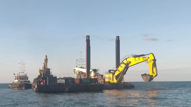
Port of Townsville prepares for cyclone
Port of Townsville has moved to Condition Orange, with commercial shipping operations at the Port finished Wednesday morning and all commercial vessels now departed and floating plant secured.
Closure of the Port landside operations was anticipated at 10am Thursday 25 January, pending changes to weather conditions.
Condition ORANGE preparations include:
- Completing removal of cargo, equipment and marine pollutants from any area that may be impacted by tidal surge or floods
- Completing tie-down or removal of all loose equipment and plant.
- Isolating part of the potable water and fire water services
- Directing non-operational staff to leave the Port
- Maintaining contact with Maritime Safety Queensland, Port tenants and users to minimise impact; and
- Reviewing resourcing plans for the coming days, particularly with respect to the recovery period.
Port of Townsville General Manager Customer, Operations and Safety, Drew Penny said Port staff were continuing to work closely with the Bureau of Meteorology, Maritime Safety Queensland and the Townsville Local Disaster Management Group as the weather system approaches.
“Our team has worked tirelessly in coordination with Port tenants and users over the past few days to prepare the Port for the severe winds and heavy rains expected as the Tropical Low approaches the coast.
“We are continuing to do all we can to minimise damage to critical port infrastructure over the coming days and to ensure we are ready to resume shipping as soon as Maritime Safety Queensland determines it is safe to do so.”
11AM TUESDAY: The Townsville Local Disaster Management Group has moved to ‘lean forward’, with sandbags offered at three locations: Lou Litster Park, Dalrymple Rd and the Ross Dam car park, corner of Bruce Highway and Mount Low Parkway, Bluewater SES Depot, Rupertswood Rural Fire Shed (14 Progress Rd, Alice River and Cungulla Community Centre.
One will include a sandbagging machine across from the Local Disaster Coordination Centre on Dalrymple Road, Garbutt, which will be set up after 2pm, January 23.
“We ask if you’re able-bodied to go to another area and fill your own sandbags. For those who aren’t able-bodied and would have difficulty we will provide you with sandbags and help you load them into your vehicle,” Mayor Jenny Hill said.
The Cr Hill also announced she would send sandbags to Cungulla and Cleveland Palms.
“It would appear under some modelling it’s really the southern part of the city that is likely to be hit most,” Cr Hill said.
As the weather event gets closer and the TLDMG gets a better indication of where it’s likely to cross they will advise the community of refuge centres they will open for at-risk residents with plans being finalised for the opening of cyclone shelters.
“Three days ago we thought we would have to evacuate 25,000 people from tidal areas,” Cr Hill said.
She said that number has significantly dropped to around 50 homes and it’s important to keep calm.
“It’s so far out to sea at the moment, it’s a bit of a ‘crystal ball’ that we have to do,” Cr Hill said.
“I know there was some criticism with the event recently, with Jasper that communities didn’t know and weren’t properly notified. We’re not going to make that same mistake.
“I want to be sure if we have to evacuate people I can stand on my soap box and say ‘you’ve got to go’ and the reasons why. I want to give the community confidence.”
The council have begun removing shade structures, stinger nets and anything at risk of damage from high wind gusts or coastal activity.
Because of the risk of high winds Cr Hill said they won’t be considering outdoor events for Australia Day with plans for citizenship ceremonies and other presentations to be moved inside.
Damaging winds and gals up to 120km/h are expected to begin as early as Wednesday evening, hitting the area between St Lawrence and Townsville. The winds would extend towards coastal and inland communities between Cairns and Townsville during Thursday.
Destructive wind gusts are expected on Thursday, reaching up to 150km/h between Cardwell and Bowen.
There are serious concerns about a dangerous storm tide impacting the coast between Townsville and Mackay with the sea level expected to rise steadily to a level well above the normal tide.
Flooding to low-lying areas close to the shoreline is expected.
Ergon has warned North Queenslanders to be prepared for power outages and prioritise electrical safety.
General manager field delivery northern Chris Hooper said recent severe weather events were a reminder of what to expect and plan for.
“We can start to see the impacts of a cyclone well before it crosses the coast as winds pick up and bring down trees, branches and other debris into powerlines, so you should be prepared for prolonged power interruptions,” he said.
“Storm surges and flooding also have the potential to impact the underground power network.
“Cyclone Jasper demonstrated how severe and widespread the damage to infrastructure can be and how long repairs can take, so it pays to be prepared for the worst-case scenario.
“Think about how your household can function without power for a week or more and get your storm kit ready, especially if you rely on powered medical equipment.”
Mr Hooper said Ergon crews would be ready to roll as soon as weather conditions allowed, but flooding was likely to impede access to some sites and delay damage assessment, network repairs and power restoration.
“The unpredictable nature of cyclones means that we are always prepared for a range of scenarios, and we have crews, vehicles and equipment on standby in strategic locations to ensure we are ready to respond when and where we are required,” he said.
SeaLink has revealed that services between Townsville and Magnetic Island may cease from as early as Wednesday, January 24 at 4pm.
The ferry operator has released this information, based on the most recent advice from the Bureau of Meteorology.
SeaLink will continue to update service details as more information becomes available.
Townsville Airport says it is working with the Department of Defence and airlines to prepare the airport as necessary.
While services have not been cancelled yet, people travelling to and from the airport in coming days are urged to keep in contact with their airline about the status of flights.
More details will be released on the Townsville Airport Facebook page.
The Palm Island ferry service has been cancelled for Wednesday and Thursday.
Hinterland flights are expected to continue to the Indigenous community on Tuesday, with the service to monitor winds on Wednesday before deciding if it will operate.
The Palm Island Barge will continue until Wednesday, but has been cancelled for Thursday and Friday.
Residents prepare homes
Monday, January 22:
Gulliver resident Nicole McMahon didn’t waste time getting her sandbags from Lou Litster Park.
“I’ve gone through all my drawers to get out the batteries, I’ve got the girls finding what food we need, I’m doing as much as I can while I’m still waiting on my pay to come through,” Ms McMahon said.

“Gulliver is an old suburb. When Hugh Street goes down our end of Tippett Street is the first to flood.”
Ms McMahon said she’ll used the sandbags to barricade her laundry and bathroom, which are both built at ground level behind her low-set rental.
“We’ve been living here four years, and once the toilet goes down, pretty much the entire street’s toilets go,” she said.
“We knew five of our neighbours last year and we had a nice little community going, but they’ve all gone and I don’t know anyone. I’m hoping to say hello this week just to put a face to them.”
With the sandbags protecting the plumbing outlets, Ms McMahon’s next contingency plan is her new cyclone-rated shed in the backyard.
“If the house starts leaking, I’ll move the kids and the dogs in there,” she said.
Chief Inspector Damien Crossby encouraged new residents to use the online Disaster Management Board and said that emergency services personnel will be pre-deployed to Palm Island and the Burdekin prior to the weather event.
“Everyone has a responsibility to plan, prepare and have an emergency action plan ready,” he said.
Cruise ships cancel visit
Highly touted, internationally esteemed cruise ship Vasco da Gama has cancelled a leg of its most recent journey that would have brought it to Townsville as the city continues to await news of expected Tropical Cyclone Kirrily.
Over 1500 prospective visitors will now be detoured elsewhere as the cruise ship avoids North Queensland due to the presence of a tropical low off the coast.
Townsville Enterprise Limited’s Director of Visitor Economy and Marketing Lisa Woolfe said the cancellation would represent a substantial blow to the NQ economy.
“Today’s cancellation of the Vasco da Gama is a hit to our local tourism economy, with more than $330,000 in economic injection that was anticipated from this vessel. This comes off the back of the industry already feeling the brunt of cancellations and slow forward bookings in response to Cyclone Jasper,” Ms Woolfe said.
Billabong Sanctuary owner and operator Bob Flemming said the business had been anticipating a significant influx of people from the cruise ship and that the news was disappointing.
“While we understand Vasco da Gama’s decision to divert from Townsville due to the potential cyclone, it is disappointing we won’t be able to welcome the international visitors that this ship would have brought,” Mr Flemming said.
Originally published as Townsville cyclone: Kirrily on track to North Qld as BOM releases latest forecast
Join the conversation

Why most Queenslanders don’t want ‘cheap’ Games
Many Queenslanders have resoundingly rejected Premier Steven Miles’ no frills option for an Olympic Games stadium, instead backing the more ambitious proposals which could also lure major artists like Taylor Swift to Queensland. SPECIAL REPORT
Read more

Woman left with ‘life-threatening injuries’ after alleged DV attack
Police have declared a crime scene after a 41-year-old woman suffered ‘life-threatening injuries’ during a shocking alleged domestic violence-related attack in Townsville.
Read more