
kunanyi/Mt Wellington still covered in snow
Thick snow has continued to blanket kunanyi/Mt Wellington, with honeymooners taking the opportunity to build a snowman. LATEST>>

Tasmania
Don't miss out on the headlines from Tasmania. Followed categories will be added to My News.
Thick snow has continued to blanket kunanyi/Mt Wellington, with honeymooners taking the opportunity to build a snowman.

kunanyi/Mt Wellington Explorer Bus posted a great shot of the newly weds on their Facebook this morning, with the happy couple posing with a mini snowman.
Snow is also still covering popular ski spot Mt Mawson.
Large swells up to 4-5m were also expected on Wednesday and Thursday but strong southwest winds were likely to keep most surfers at bay.
How to see snow when the gates close - May 18
TASMANIA has started off the week with a wintry blast as temperatures plummeted and snow blanketed peaks across the state on Monday – and the seven-day forecast offers little reprieve from winter’s bite.
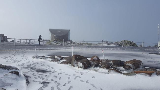
kunanyi/Mt Wellington was given a dusting of snow as temperatures plummeted to a top of 3C.
kunanyi/Mt Wellington Explorer Bus managing director Jonathon Gregory said Tasmanians were flocking to the bus service after seeing snow on the mountain this morning.
“It’s absolutely exciting - the buses are working really well and they are well patronised,” Mr Gregory said.
“We’re running to schedule and we are near capacity, there are four departures a day from the city.”

People have been urged to book in advance to ensure they can get up the mountain, with the shuttle service the only opportunity to drive to the summit while Pinnacle Rd is closed in these conditions.
The occasional surges in passenger numbers were all part of the fun of running the service, Mr Gregory said.
“We don’t actually have a snow season - it’s quite sporadic so we can have snow today and not the following day,” he said.
“We have the ability to increase departures when snow springs up, commonly on the weekend and there’s plenty of sun out so people can clearly see the snow on the mountain … that’s when we have our busiest days.”
Snow also covered ski fields at Mt Mawson in Mount Field National Park.


The cold front brought with it a sheep graziers alert in the Upper Derwent Valley for extremely cold temperatures, which was downgraded on Monday afternoon.
A large high is expected to roll in from Friday, with wintry conditions and frosty mornings ahead.
Damaging wind warning for #Tas was cancelled overnight, still strong and gusty w-nw winds today, will moderate a little Tuesday but increase again on Wednesday. Wintry days, frosty morns coming up from Fri onwards as a huge high rolls in, looking like a good wknd this time round!
— Bureau of Meteorology, Tasmania (@BOM_Tas) May 15, 2022
Maximum temperatures for lowlying areas of the state will hang around the 10-15C range into the weekend with alpine snow dusting high Tasmanian peaks over the next three days.
A bushwalkers warning for the western forecast district remained current at time of publication.
Hikers were advised that snow as low as 800m was expected during Monday evening.
Large swells up to 4-5m were also expected on Wednesday and Thursday but strong southwest winds were likely to keep most surfers at bay.
‘Damaging wind, thunderstorms’: Weather warning issued for north
3pm Sunday May 15
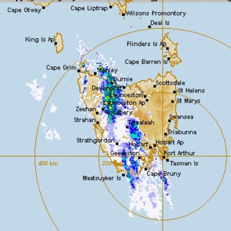
A severe weather warning has been issued for large parts of the state as a strong and gusty front crosses western and northern Tasmania later today.
According to the Bureau of Meteorology, a cold front crossing The Bight is forecast to hit western Tasmania this afternoon, before crossing the state during the evening and overnight.
The BOM expects it to bring sustained strong winds and gusty showers and thunderstorms.
Forecasters said damaging winds averaging 60 to 70 km/h with peak gusts of around 100 km/h are likely in Tasmania’s west and far north west from mid afternoon, before moving across northern parts of the state during the evening.
Update to the severe weather warning for #Tasmania with potentially damaging winds from mid-afternoon about the W and far NW, extending to the N and Central Plateau in the evening. Warning to sheep graziers and bushwalkers weather alert also current for Mon, with snow to ~700m. pic.twitter.com/AGV8pLQny4
— Bureau of Meteorology, Tasmania (@BOM_Tas) May 15, 2022
“Damaging wind gusts are most likely with showers or thunderstorms,” a BOM statement said.
“The damaging wind risk is expected to contract to the northeast of Tasmania late in the evening, and then clear the state by early morning, leaving a moderately gusty westerly stream over Tasmania on Monday.”
“Locations which may be affected include Devonport, Burnie, Smithton, Launceston, Scottsdale, Strahan and Queenstown.”
Originally published as kunanyi/Mt Wellington still covered in snow

Crafters love the challenge Rum’un offers
Tasmania’s love for Devils’ mascot Rum’un continues to grow with one shop creating its own merch in homage to the unique character.
Read more

‘Heavy hearts’: Popular Tassie craft brewery placed into administration
A beloved Tasmanian craft brewery has been placed into voluntary administration while its financial backer is investigated by ASIC, with its owners vowing to “come through the other side”.
Read more