
CYCLONES are a part of life in Far North Queensland.
Each year from November until April, we wait to see what the Coral Sea will throw at us.
From Australia’s deadliest cyclone, Mahina, in 1899 to the $800m damage bill caused by Yasi in 2011, cyclones test our spirit but also highlight our resilience.
This special three-part series explores how cyclones affect the lives of Far North Queensland residents.
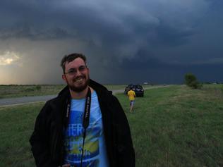
In Part 3, weather enthusiast Jacob Grams tells of his passion for storm chasing and what makes weather in the Far North unique.

BEING a storm chaser in Far North Queensland is not as idyllic as some people might think.
Don’t get me wrong, plenty of interesting stuff goes on in this part of the world, or more specifically in those fluid layers of atmosphere above our heads.
It really depends what you’re into.
Some chasers I’ve met in the past six years in the US an in southeast Queensland, where I was based up until six months ago, drive straight into thunderstorms to find the biggest hailstone.
There’s not much chance of that in the Far North, but it can happen, just ask the farmers in Innisfail who bore the brunt of a severe storm in November last year (while I was in southeast Queensland chasing blue sky).

I like to keep my distance somewhat, check out the structure of the clouds and look to capture a crazy lightning bolt without getting fried.
This lends itself to isolated thunderstorms with strong updrafts that command all the energy of the surrounding atmospheric environment.
That’s where my problem lies. In the tropics there’s so much moisture around that any disturbance leads to clouds forming anywhere and everywhere all wanting their little piece of energy.

Usually it means showers or what we call “pulse” storms that last barely enough time to get your camera gear together.
If there was colder air in the upper levels of the atmosphere, the development might be more vigorous and storms could be longer-lived.
It’s another story hoping they happen in the few areas of suitable terrain with a nice view of everything unfolding in front of you.

The advantage southeast Queensland has is, being a subtropical area, the collision of hot, moist and cool, dry air masses, creating instability and thunderstorms with a decent degree of predictability.
So much so I made a 36-hour mercy dash to Brisbane and back before Christmas in the hope of storms and jumped in a car with mates headed to the southern Darling Downs region.
We were rewarded with a spectacular rotating low-precipitation supercell north of Goondiwindi and a lightning show lasting far too long for me to stick around to watch (another symptom of a heap of cold air aloft).
But one thing I’d like to check out, if it happens, is how thunderstorms act in the bands or the wake of a tropical cyclone.
It’s business time in the Coral Sea so it should only be a matter of when.

Add your comment to this story
To join the conversation, please log in. Don't have an account? Register
Join the conversation, you are commenting as Logout
Who Owns Tassie’s farms: Biggest investors, landholders named
An annual investigation can reveal Tasmania has been a key destination for capital in the race to invest in Aussie agriculture. See the full list.
Families, billionaires and foreign owners of SA’s largest farms revealed
From sprawling stations in the north to prime cropping in the south – meet those who own South Australia’s largest farming properties. See the full list.