
No end to crazy weather as SES responds to hundreds of calls for help as wild winds batter Adelaide
Flights have been grounded at Adelaide Airport and thousands of properties across Adelaide are without power this morning as SA’s wild summer weather continues.
SA News
Don't miss out on the headlines from SA News. Followed categories will be added to My News.
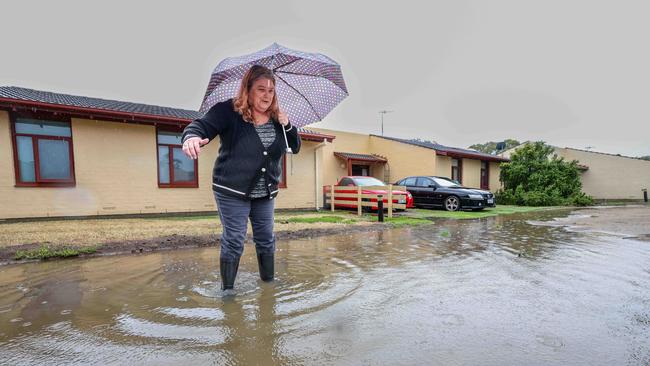
Stormy weather has again pummelled parts of South Australia again overnight, downing trees – leaving thousands of properties without power – and flooding roads.
Some flights were delayed at Adelaide Airport earlier this morning due to the lightning, almost a week after wild weather caused similar issues.
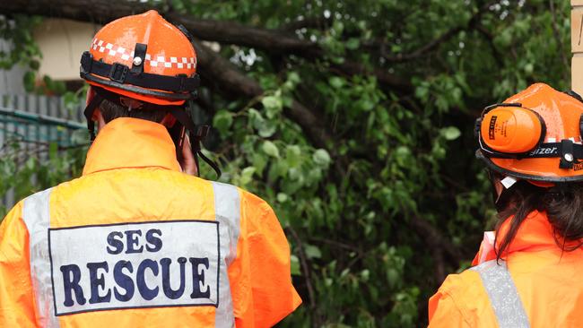
Since Friday, the SES has received 550 callouts, mainly for trees and branches smashing into properties, including on the corner of Pirie and Pulteney streets in the CBD, and on Anzac Hwy at Glenelg.
Across SA, there were 61 outages affecting more than 20,000 customers just after 8am on Monday morning – up from just a few thousand earlier in the Monday.
In the eastern suburbs almost 1100 properties in Dulwich, Eastwood, Fullarton, Glenside, Kent Town, Norwood, Rose Park, Toorak Gardens and 1700 in Beulah Park, Kensington, Kensington Park, Marylands and Norwood are in the black. The traffic lights at the Fullarton/Greenhill roads intersection are out.
Click here for latest on the stormy weather
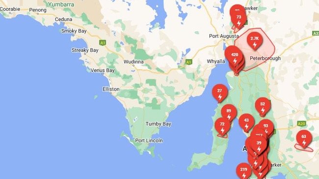
In Adelaide’s north-east, almost 2500 properties in Athelstone, Highbury, Hope Valley, Houghton, Montacute, Paracombe, St Agnes, Upper Hermitage and Vista have lost power, while Modbury, Redwood Park, Ridgehaven and St Agnes are also affected with almost 900 properties hit.
Outside of Adelaide, about 2700 homes in the mid-north near Peterborough are without power.
The wild conditions are expected to ease by this afternoon with Adelaide expecting a top of 29C on Monday.
It follows an hour of power on Sunday that toppled trees and cut electricity supplies to thousands of residents.
The State Emergency Service received almost 150 calls for help from midnight to 5pm, with about half of those occurring inside an hour.
The Bureau of Meteorology warned of damaging winds in the Adelaide Hills, eastern and southern suburbs of Adelaide, and the Mid-North district.
Sellicks Hill recorded winds of 69km/h, gusting to 85km/h at 2.30pm, just outside the hour of havoc that sent SES crews scrambling to Aldinga Beach as other calls for help rushed in.
The bureau said the risk of damaging gusts in excess of 90km/h were possible until late Monday morning.
SES media liaison Phillip Krasnoff said of the 144 calls for help to 5pm Sunday, more than half were received from 3.30pm – 4.30pm.
“We were expecting flooding to happen in the Eyre Peninsula but we haven’t seen that,” he said.
Instead it has been reports of trees down and some water through roofs.
“We’ve got crews across the state and we have given them the heads up to prepare for the wind activity,” Mr Krasnoff said.
“We also have crews on standby.”
Residents are urged to take storm preparation measures including securing loose items in their properties, moving vehicles out from under trees and under cover, and for them to stay indoors and away from windows.
SA Power Networks spokesman Paul Roberts said technicians were “resourced and ready to respond in the Hills and metro area overnight”.
“We’re expecting strong winds from the east, and with that the risk of trees falling and downed power lines which could lead to outages,” Mr Roberts said.
A spokesman for the Bureau of Meteorology said Sellicks Hill recorded the highest wind speed seen in SA today, peaking at 85 km/h at around 4pm.
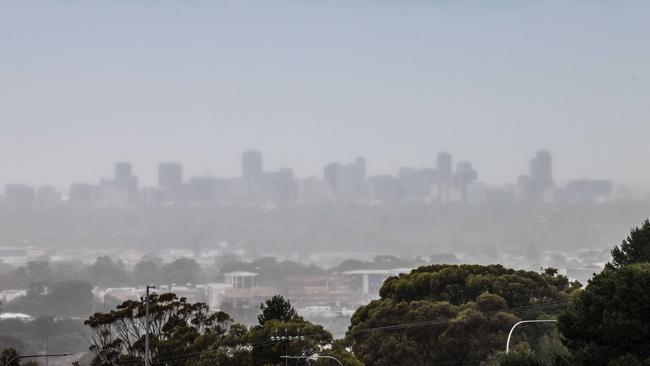
The Adelaide metro was battered by 40-60km/h winds coming from the south which gave it a colder bite, while average rainfalls reached 30-40mm in the last 24 hours.

Wild weather set to ease as the week begins with a top of 30C
A weekend of thunderstorms, flash floods and heatwaves is set to ease this week with warnings downgraded.
While Sunday’s top was 17C in Adelaide, Monday will see a significant rise in temperature with a high of 29C.
The day is set to be partly cloudy with a high chance of a shower or two, with possible rainfall of 5mm.
The following two days in Adelaide are predicted to stay in the high 20s, with Tuesday expecting a maximum of 26C and Wednesday a high of 27C – before temperatures drop again to a top of 23C on Thursday.
Although the tail end of the week will see temperatures in the low 20s, the chance of rainfall will drop drastically.
Thursday is set to see a medium chance of a shower or two, while Friday will see clouds clearing and a 10 per cent chance of rain.
While Port Augusta will see a top of only 25C on Monday, temperatures will rise by Wednesday to a top of 31C.
Port Lincoln is forecast to have temperatures in the low to mid-20s and partly cloudy, while Coober Pedy will reach 35C by Saturday.
Temperatures will reach a maximum of 40C in Renmark on Monday after a top of 27C on Sunday.
However the Riverland town won’t see a sunny day till Friday with a high of 29C.

Senior meteorologist at the Bureau of Meteorology Simon Timcke said “the wettest period for Adelaide is behind us”.
“We have seen an easing of the rainfall,” he said.
“Conditions will get windy in the late afternoon (Sunday) until late Monday afternoon.”
Mr Timcke said Friday would likely be Adelaide’s driest day after 31.2mm of rainfall fell between 9am Saturday and 1.30pm Sunday.
The North East Pastoral heatwave warning dropped on Sunday.
“While temperatures have reduced, hot weather may still be experienced. It may take you a few days to recover and you should continue to take care,” a warning issued by SES said.
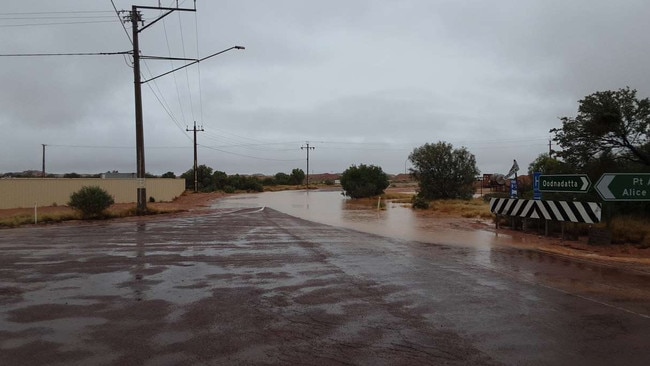
The SES issued a flood advice warning for the Eyre Peninsula, Yorke Peninsula, western parts of the Flinders Ranges and Mid North and parts of the North West Pastoral areas.
“There is a risk of localised flooding for the Eyre Peninsula and parts of the North West Pastoral areas which may threaten you and your family’s safety,” the warning advice message said.
“Heavy rain is forecast across the warning areas on Sunday into Monday morning.”
Some outback roads across the Eyre Peninsula have been forced to close amid rainfall.
The following roads are closed to all vehicles:
Iron Knob to Hiltaba: Nonning Rd, Hiltaba Rd
Thurgla Station to Kimba: Buckleboo Rd
Yardea Station to Minnipa: Yardea Rd
Kingoonya to Wirrulla: Gawler Rangers Rd
Skull Tanks to Pondana Ruins via Kangaroos Well: Skull Camp Tanks Rd
Tarcoola to Glendambo: Tarcoola Rd
Kingoonya to Stuart Highway: Gosses Rd
Roxby Downs to Bopeechee: Borefield Rd
William Creek to Marree: Oodnadatta Track
Coober Pedy to William Creek: William Creek Rd
Oodnadatta to Coober Pedy: Kempe Rd
Mt Barry to San Marino: Evelyn Downs Rd
Mt Barry to Arckaringa: Arckaringa Rd
Mt Dare to Hamilton: Mount Dare Rd
Painted Desert Rd
Yorkeys Crossing (Port Augusta Heavy Vehicle Bypass)
Cooper Creek Ferry Crossing Rd
Birdsville Inside Track
The SES received 48 requests for help from midnight to 12pm Sunday. On Saturday, 125 requests were reported including 58 for fallen trees and 15 for flooding and flash-flooding incidents.
“The majority of those calls occurred in our southern areas as the rain swept through Adelaide (Saturday),” SES state duty officer Brenton Clarke said.
“There’s been no reported significant damage but there has been some damage to homes and fencing.”
“Across the state it was generally not too bad with the steady downpour throughout the day.”
Mr Clarke said there were 21 callouts in the Eyre and York peninsulas and the Hills region.

Originally published as No end to crazy weather as SES responds to hundreds of calls for help as wild winds batter Adelaide
Join the conversation

‘I don’t think I’d still be here’: Mum’s raw 27-week abortion story
A South Australian woman has given a raw and personal account of what her late-term abortion was like and why she chose that path.
Read more

Dramatic scenes as abortion vote descends into chaos
A Liberal MP is furious with party colleagues after late night drama erupted over what was expected to be a foregone conclusion.
Read more