
Warnings of significant flooding, erosion as Tropical Cyclone Alfred set to head for southeast
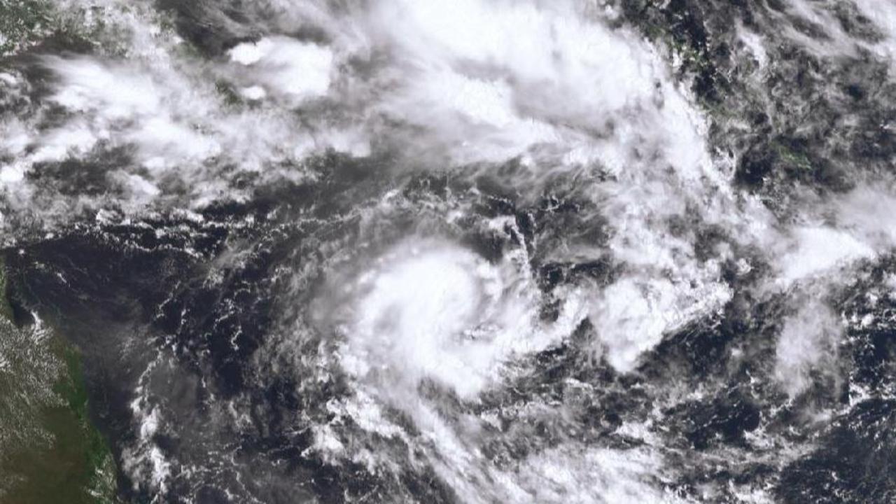
Tropical Cyclone Alfred has intensified overnight, and the latest data suggests it will cross the Queensland coast, with millions of residents in the southeast being told to prepare. LATEST DEVELOPMENTS
QLD News
Don't miss out on the headlines from QLD News. Followed categories will be added to My News.
Millions of Queenslanders are being told to prepare amid warnings of the first cyclone to cross the state’s southern coast in half a century.
Tropical Cyclone Alfred could make landfall in South East Queensland by Thursday as a category 2 system – packing gale-force winds and up to 600mm of rain.
SCROLL DOWN FOR ALL THE LATEST WARNINGS
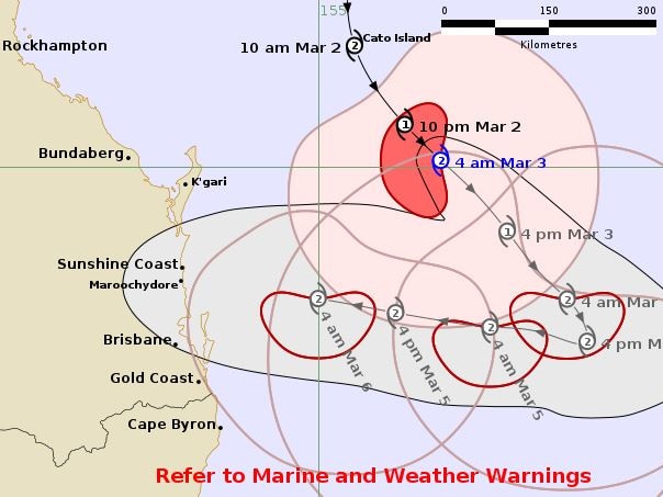
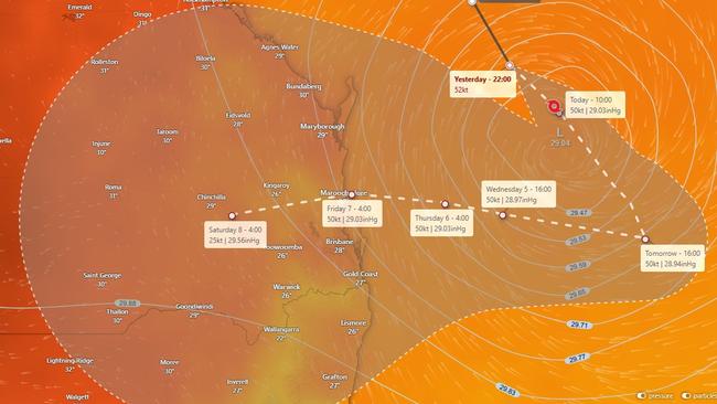
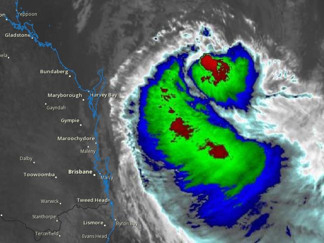
Alfred was downgraded to a category 1 system on Sunday but has since restrengthened back to a category 2 system on Monday morning and is expected to continue towards the southeast moving at 13km/h.
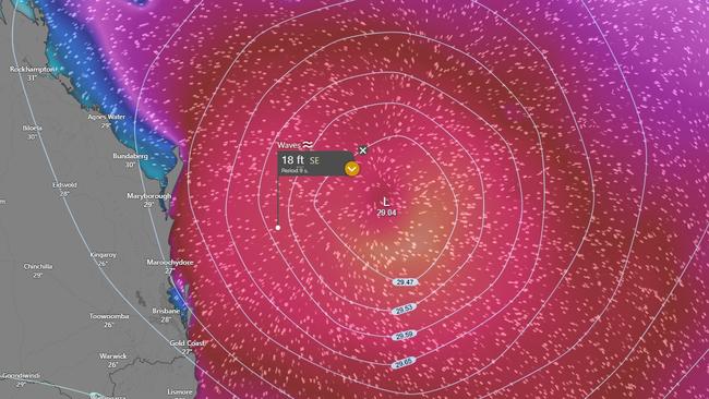
In its latest report, at 4am on Monday, the Bureau of Meteorology said Alfred is a category 2 system about 465km northeast of Brisbane and 401km east northeast of Maroochydore, heading south.
BE PREPARED: CYCLONE SAFETY GUIDE
It is forecast to slow down and turn westward from Tuesday, moving towards the southern Queensland coast, and is then expected to make landfall somewhere along the coast from Bundaberg to the Gold Coast on Thursday as a possible category 2 system.

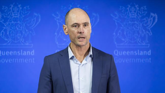
Speaking to ABC Radio on Monday morning, Premier David Crisafulli urged Queenslanders to get prepared for the cyclone – the first to cross the state’s southern coast in half a century.
“It did intensify overnight, and all of the modelling from the bureau is showing that it will cross the coast, so that has firmed up overnight,” he said.
“We have to make sure that people are taking those precautionary approaches.”
Mr Crisafulli said he saw the preparation in three phases: coastal erosion, winds and flooding.
He said details on the strength of the wind that could be expected will be firmed up towards the middle to the back half of this week.
“We’ve got a little bit of time, but those winds will be challenging,” he said.
Mr Crisafulli said flooding on the southern part of the system will be a big risk.
“When you’re talking about falls of a few hundreds millimetres or more in a short period of time, there will be a challenge, so it’s important that people do all the little things you can at your place,” he said.
“When you look at how wide the area is at the moment of where this potentially could cross, that means that there will be a community that does experience a fair amount of rainfall in that southern part of the system, and it will be a populated area.
“We’re already prepositioning generations and some of our island communities.
“There’ll be some challenges for people, and they will have to make a decision whether to go or stay.”
Residents in flood-prone areas are advised to keep up to date with warnings and advice as rain was set to intensify across the coming days, with a flood watch issued for both Queensland and New South Wales.
“Heavy rainfall (will increase) from late Wednesday continuing into Thursday and Friday and catchments across Queensland are dry to moderately wet,” he said.
“As well as the abnormally high tide coming through it does increase the risk of flooding for those coastal low lying areas but once the rainfall does pick up we could see minor to major flooding across the Queensland flood watch area from late Wednesday.”
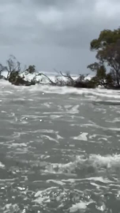
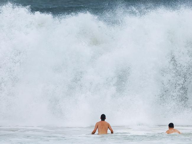
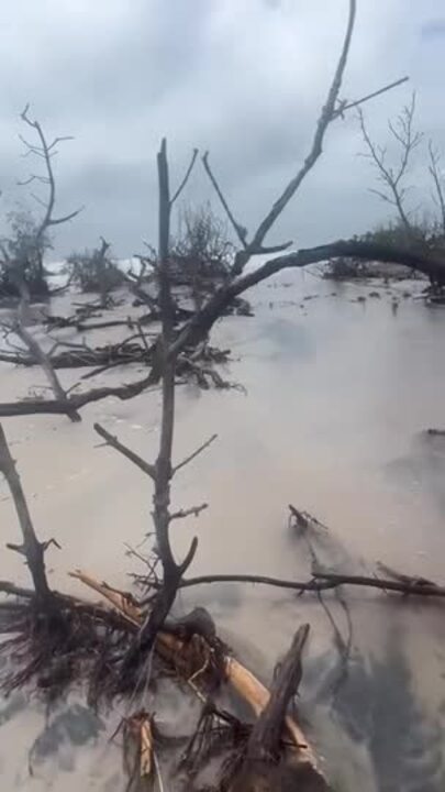
Mr Crisafulli said Queensland has experienced challenges with coastal erosion after reports of 15m swells off the coast of Wide Bay.
“We’ve seen some significant erosion in little parts of the Great Keppel Island, and people would have seen breakthrough on the north part of Bribie (Island) through the Pumicestone Passage into Caloundra, so that is an area that we’re definitely of concern and we’re certainly watching,” he said.
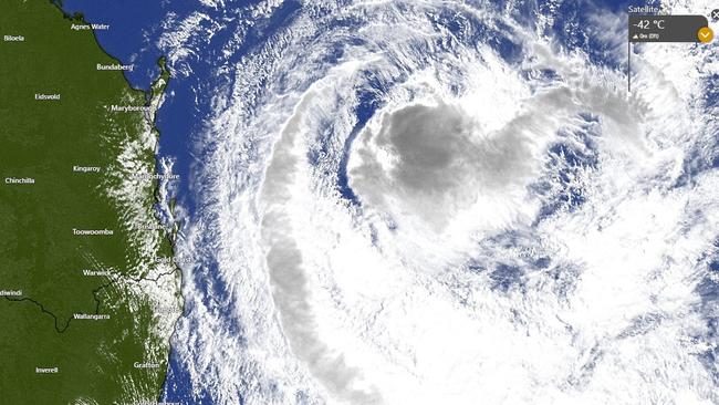
Senior meteorologist Jonathan How on Monday morning said latest observations showed sustained winds near the centre of the Cyclone of 95km/h and wind gusts to 130km/h.
Coastal hazard marine warnings remain in place for southeast Queensland and northeast New South Wales, as damaging winds are set to increase from Wednesday and sustain until Tropical Cyclone Alfred draws near.
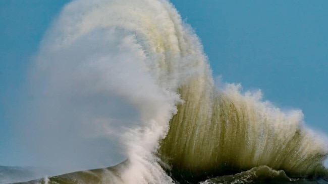
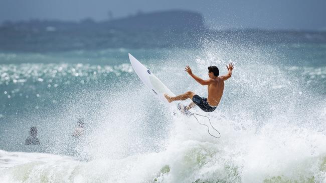
Mr How said abnormally high tides and powerful waves have led to beach erosion in southern parts of Queensland and will continue.
“We do have marine wind warnings all the way from K’gari to the Sunshine Coast off Brisbane, Gold Coast and northern rivers of New South Wales for strong to gale force winds,” Mr How said.
“Those high-tide peaks will gradually start to reside from today, but those strong waves coming from the east will persist for several days as Tropical Cyclone Alfreds sits off the coast.”
Past cyclones to reach SEQ
Mr Crisafulli and Brisbane Lord Mayor Adrian Schrinner on Sunday evoked the memories of historical storm events as a wake-up call for southeast Queenslanders to ready their properties.
The last time an active cyclone crossed the coast so far south was Nancy in 1990, which, after tracking south just offshore of Brisbane, brushed Byron Bay – bringing up to 530mm of rainfall.
Before that you need to go back to Cyclone Zoe, which made landfall on March 12, 1974 just north of Tweed Heads – and then what has become known as the Great Gold Coast Cyclone, which caused extensive damage in 1954 when it crossed as what would now be called a category 3 system.
The severe weather – which has already prompted Queensland authorities to call in the Australian Defence Force – meant flood watches had been issued for river catchments from the Mary River at Gympie south to the Gold Coast.
Premier Crisafulli sought to shake southeast Queenslanders from any complacency over a cyclone threat.
“There may be Queenslanders who can be forgiven for thinking that this is something that doesn’t occur – well, history shows that it does, and that’s why we are taking that precautionary approach and asking people to do everything you can to get ready,” he said.
Mr Crisafulli said he expected a formal Tropical Cyclone Warning would be issued in coming days, but the signs were already serious enough for the government to enter what he called “a precautionary and preparation phase”.
“We will work with the councils as well as statewide messaging to make sure that messages are up to date, accurate, and by working with those telco providers, we can get them in real time, or as close as possible to real time,” he said.
Acting Police Commissioner Shane Chelepy warned the window would soon close to leave islands including Moreton and North Stradbroke, and those in the inner-bay.
“I ask you to think about the risk for you and make a decision as to whether or not you should leave those islands and when you should leave those islands, because that window to leave the island will close later in the week,” Mr Chelepy said.
He said he had been in contact with the National Emergency Management Agency and the Australian Defence Force to co-ordinate planning ahead of the weather event.
Bureau of Meteorology senior forecaster Felim Hanniffy said a little upper trough moving across southeast Australia was helping drag Alfred southeast.
The warmer than usual waters south have also let Alfred maintain its status as a tropical cyclone.
Mr Crisafulli said he had spoken to telecommunication companies about freeing up bandwidth so critical messaging was not disturbed.
“I’m determined to make sure that everything humanly possible is done to provide the capacity to get as many messages to as many people as quickly as possible,” he said.
All schools so far would remain open, the Premier said, but he asked supermarkets to ensure adequate stock had been delivered.
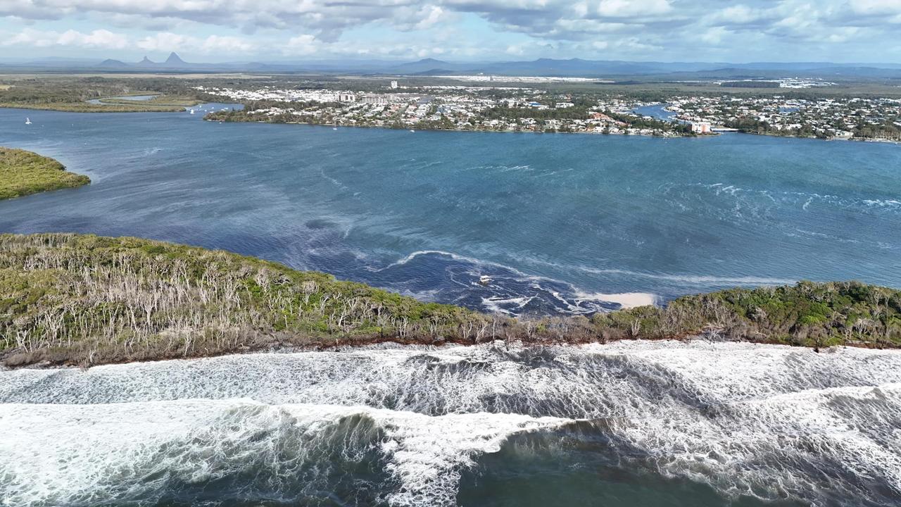
He highlighted the particular challenge for the Pumicestone Passage, where suburbs around Golden Beach could be impacted should the weather see a breakthrough along the northern part of Bribie Island.
“I am mindful that there is a real challenge there because of how severe the breakthrough has been in recent times and the prospect of those winds coupled with big tides presents a real challenge in that Pumicestone Passage area,” Mr Crisafulli said.
Mr Crisafulli’s key message was for Queenslanders to be prepared and keep up to date with the warnings.
“It’s important that people do everything they can to also stay connected,” he said.
“Text messages is one element, but it’s also important that people, for example, go to the Disaster Queensland website, that they go to the BoM’s website.”
Speaking to ABC Radio on Monday morning, Mr Crisafulli said a decision to reschedule any AFL games has not been made yet after communicating with Brisbane Lions chief executive Greg Swann.
“Greg tells me that both of the teams have a bye in round three, so there is the opportunity for that game to be rescheduled,” he said.
“It may be that there is an opportunity for that game to be rescheduled.
“I’m sure they’ll do that with plenty of time for people to make arrangements, and we wish them all the best for the season.”
He said the state government will be providing them with information and they will make the call on Thursday night.
LATEST WEATHER WARNINGS
Coastal hazard warning
The Bureau issued a Coastal hazard warning for people in parts of Wide Bay and Burnett and Southeast Coast forecast districts at 4.21am on Monday.
It warns of abnormally high tides and damaging surf along the southeast Queensland coast.
“Tropical Cyclone Alfred is moving southwest through the Coral Sea generating large and powerful east to northeasterly waves,” the warning says.
“These waves will combine with spring tides to produce abnormally high tides and severe beach erosion for southern Queensland. High tide peaks will start to recede slightly from today but large waves are expected to persist for several days as Alfred remains in the southern Coral Sea.
“Water levels on Monday morning high tide may exceed the highest tide of the year by less than half a metre and ease further into Tuesday but may start to increase again during the week depending on the movement of Tropical Cyclone Alfred. This could lead to minor flooding of the foreshore and coastal erosion.
“Damaging surf conditions leading to significant beach erosion are likely between Sandy Cape and Coolangatta, and may also continue throughout most of next week depending on the movement of Tropical Cyclone Alfred.
“A Hazardous Surf Warning is also current for Capricornia, K’gari, Sunshine and Gold Coast waters.
“Locations which may be affected include Gold Coast, Maroochydore, Coolangatta, Moreton Island, North Stradbroke Island, Noosa Heads, Rainbow Beach, and K’gari.”
Hazardous surf warning
The Bureau issued a hazardous surf warning at 4.21am on Monday for K’gari Coast, Sunshine Coast Waters and Gold Coast waters, with surf and swell conditions expected to be hazardous for coastal activities such as rock fishing, boating, and swimming.
People are advised to stay out of the water and avoid walking near surf-exposed areas.
Rock fishers are advised to avoid rock platforms that are exposed to the ocean.
Boaters are advised to reconsider their plans if they involve crossing shallow water and ocean bars, and those already on the water should carry the appropriate safety equipment and wear a lifejacket.
Flood watch
An initial flood watch has been issued for South East Queensland, with the prospect of widespread minor to major flooding with significant localised flooding possible later this week.
The warning, issued on Sunday afternoon, said heavy rainfall associated with Tropical Cyclone Alfred is likely from late on Wednesday, continuing on Thursday, Friday and into the weekend.
“High sea levels and large waves are likely at coastal locations, and may exacerbate flooding and cause flooding impacts,” the warning said.
“Minor to major flooding may develop across the flood watch area from late Wednesday into Thursday.
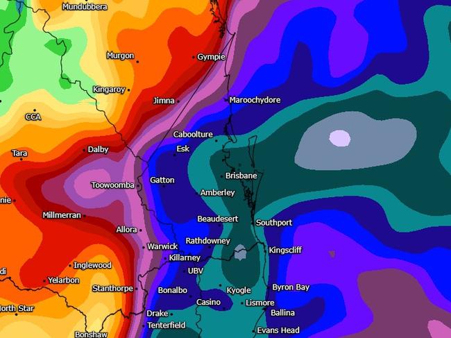
“The location of the most severe flooding will depend on the location of the heaviest rainfall, and the areas at risk will continue to be revised during the coming days.
“Rapid river levels rises and flash flooding is expected across many creeks, associated with the heaviest rainfall with widespread, including major, riverine flooding possible.”
Catchments likely to be affected include:
Mary River
Noosa River
Sunshine Coast Rivers and Creeks
Pine and Caboolture Rivers
Upper Brisbane River
Lower Brisbane River
Logan and Albert Rivers
Gold Coast Rivers and Creeks
Marine wind warning
Wind warnings for March 3
Gale Warning for the following areas:
Capricornia Coast, K’gari Coast, Sunshine Coast Waters and Gold Coast Waters
Strong Wind Warning for the following areas:
Hervey Bay and Moreton Bay
Wind Warnings for Tuesday 4 March
Strong Wind Warning for the following areas:
Capricornia Coast, Hervey Bay, K’gari Coast, Sunshine Coast Waters, Moreton Bay and Gold Coast Waters
Originally published as Warnings of significant flooding, erosion as Tropical Cyclone Alfred set to head for southeast
Join the conversation
What should I pack? How do I prep house? Qld cyclone safety guide
With residents from Bundaberg down to the NSW coast urged to prepare for Tropical Cyclone Alfred, here’s everything you need to know about staying safe during a cyclone. QUESTIONS ANSWERED
Read more

Trump should be ashamed of himself – but he never, ever will be
Everything with Donald Trump is transactional. It’s how he became a billionaire – not doing anything without getting something in return.
Read more