
NT weather: Cyclone risk falls as Victoria River flooding continues
A tropical low over the Gulf of Carpentaria is expected to move the NT’s heavy rainfall to North Queensland, but flood waters have continued to inundate some parts of the Territory.
News
Don't miss out on the headlines from News. Followed categories will be added to My News.
A tropical low that could develop into a cyclone is on its way out of the Territory, taking heavy rainfall to North Queensland instead.
Bureau of Meteorology senior meteorologist Billy Lynch said the tropical low was currently located on the coast between Borroloola and the Queensland border.
A tropical low over northeast #NT is bringing rain and gusty storms to parts of northern #Aust and is forecast to move over the southwest Gulf of Carpentaria from Sunday. For latest warnings check 👀 https://t.co/vgisNf20Erpic.twitter.com/IlaE2Y9Nx5
— Bureau of Meteorology, Australia (@BOM_au) March 4, 2023
Mr Lynch said the tropical low had a “low risk of developing into a Tropical Cyclone” at just 10 per cent.
“We’re expecting it to move out over water in the southern Gulf of Carpentaria later today (Sunday),” he said.
“It’s going to remain there for much of next week, fairly slow moving, but what that means is that most of the heavy rainfall will stay out of the Northern Territory.”
Mr Lynch said there could be some isolated heavy rainfalls in the Borroloola region on Sunday or Monday.
He said the Bureau was also keeping an eye on a trough that was expected to become more active across the Top End.
“Probably on Monday and Tuesday, we’ll see an increase in showers and thunderstorms across the Top End,” he said.
“But from Wednesday onwards, we then might see a decrease in rainfall again.”
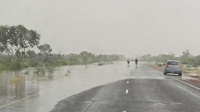
A flood watch is active for parts of the Top End, Eastern Inland, and Carpentaria Coastal catchments.
In the 24 hours to 9am on Sunday, the Bureau recorded 40-80mm of rainfall across the impacted areas.
“Catchments throughout the Flood Watch area are generally saturated and will respond quickly to further heavy rainfall,” the Bureau said.
“Rainfall is expected to cause further elevated river levels and areas of flooding.
“This may also prolong or cause renewed flooding and local ponding and overland flooding.”
The affected catchments include Waterhouse River, Roper River, Towns River, Limmen Bight River, Rosie River, McArthur River, Robinson River, Calvert River, Settlement Creek, Nicholson River, and Barkly.
The Bureau said the Upper Victoria River near Kalkarindji was no longer flooding, with the river at 2.9m and falling.
The Australian Defence Force evacuated 409 people from Kalkarindji, and finished its support efforts on Friday evening.
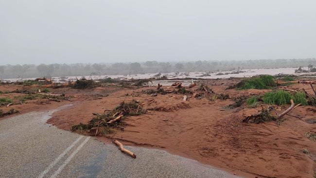
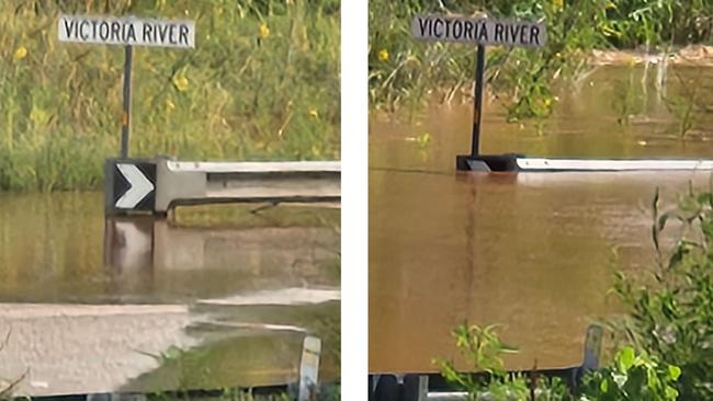
Parts of the Victoria River below Battle Creek are still rising, with floodwaters 0.87m above the Victoria River Crossing Bridge deck, which stands at 19.5m.
Victoria River Roadhouse shared photos of the rising river levels on Facebook, and said the bridge railings were no longer visible under the water.
“Unless you have a big boat, even then I doubt you will get across, there is no road,” they wrote.
The Victoria Hwy is closed, with closures at the Buntine Hwy and Victoria Hwy – towards Timber Creek – also in place.
Rail transport company Aurizon also closed a portion of the Tarcoola to Darwin railway line – from Tennant Creek to Newcastle Waters – due to the week’s significant rainfall.
“Aurizon is working with customers for the movement of critical freight by road,” an Aurizon spokeswoman said.
“Services will be resumed as soon as it is safe to do so.”
SATURDAY, 1PM: Cyclone risk remains despite break from heavy rain
Forecasters are keeping a close eye on a tropical low moving east over the Top End, with a moderate risk of a cyclone developing expected from Wednesday.
The Bureau of Meteorology’s Rebecca Patrick said a low pressure system was expected to move north east into the Gulf of Carpentaria.
“It’s expected to be slow moving for the next few days,” she said.
“Depending on the amount of time it sits over the coast there is an increased risk as we go into the middle of the week for cyclone development.”
Ms Patrick said by Wednesday it is expected to grow to a moderate risk, which carries a 20 to 50 per cent chance of a cyclone occurring.
“It’s quite close to the NT-Queensland border but there’s still a bit of uncertainty as to where exactly the position will be,” she said.
“The system could see some heavier rainfall over coastal communities on the Gulf of Carpentaria, but at the moment most of the heavier falls are on the Queensland side.
“For those coastal areas we could see isolated falls of up around 120mm.”
It comes as a severe weather warning was cancelled on Saturday morning for the Carpentaria and Barkly districts.
However the impacts of the week’s wild weather remain, with residents near the Victoria River Roadhouse preparing to evacuate due to rising river levels.
While flooding has eased around the upper Victoria River around Kalkarindji, after 600 people were evacuated from the area, levels are rising below Battle Creek as the main peak moves downstream.
River levels were expected to possibly surpass the Victoria River Crossing bridge at 19.5m overnight Saturday into Sunday, and remain elevated into next week.
Meanwhile, Telstra has contacted its customers in Kalkarindji, Daguragu, Pigeon Hole, Yarralin to offer free data and call packages as well as fixed phone connection services.
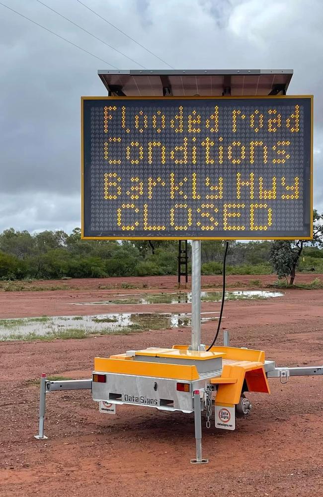
In the east, the Barkly Highway between Avon Downs and the QLD border was also closed on Saturday morning.
Several parts of the Stuart Highway north and south of Tennant Creek also remain impacted by water over the road, with some areas recommended for high vehicle clearance only.
However Ms Patrick said Darwin and the wider Top End was likely to see a decrease in rainfall over the weekend.
“We’ll continue to see rainfall over the Barkly but the good news is that over western areas, the Gregory district where we have seen significant flooding, will see less rainfall over the next few days,” she said.
“Across the Top End we’re likely to see a decrease in rainfall this weekend but perhaps some heavier showers and storms returning early next week.”
More Coverage


Originally published as NT weather: Cyclone risk falls as Victoria River flooding continues
Join the conversation

Wong dodges media, gives priority to ABC
The mainstream media were left hanging on Sunday when Foreign Minister Penny Wong rocked up to a major media event on the condition she would only speak to one particular outlet.
Read more

Private prison officers duties to be expanded in NT
The duties of private prison staff have been expanded by the NT Government provoking concerns from United Workers Union members about the privatisation of the corrections system.
Read more