
Australians brace for stormy New Year’s Eve washout
Millions of Aussies have been urged to prepare for a thunderous start to 2024, with storms and wet weather mounting to New Year’s Eve.

Weather
Don't miss out on the headlines from Weather. Followed categories will be added to My News.
Millions of Aussies have been urged to brace for a wet start to 2024, with severe thunderstorms forecast to return from this weekend, including on New Year’s Eve and New Year’s Day.
Storms are expected to develop across large parts of Australia during the final weekend of 2023, threatening to dampen NYE celebrations in several capital cities.
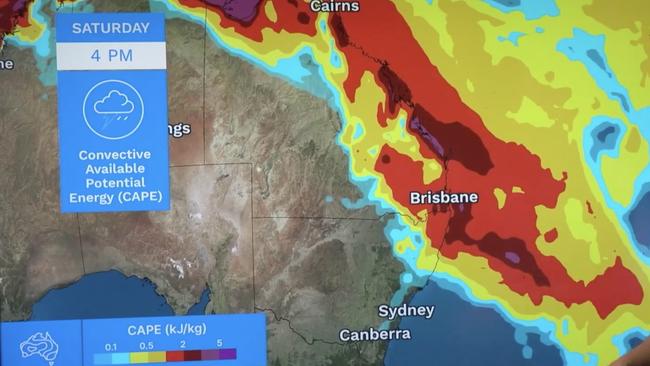
Maps from the Bureau of Meteorology show significant potential energy, which helps to drive thunderstorms, building across northeastern NSW, the entire Queensland coast and the Cape York peninsula from Saturday through to Sunday.
“In this area, we could see isolated, very dangerous thunderstorms bringing flash flooding, destructive winds and giant hail,” said BOM meteorologist Jonathon How.
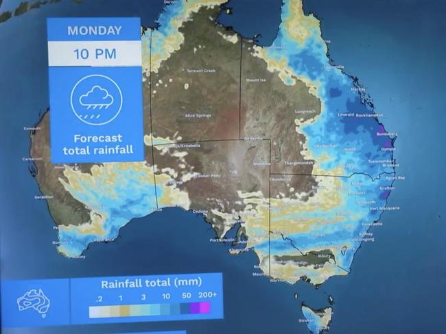
A whole weekend of wet weather is on the cards, with rainfall forecast in every state and territory. An illustration from the BOM shows widespread rainfall totals or 50mm of higher between Friday and Monday across the Queensland coast and northeastern NSW.
The wettest totals are expected around Bundaberg, Gympie, Rockhampton and Grafton, where falls could exceed 100mm.
Brisbane and Sydney are expected to be the worst-affected capitals.
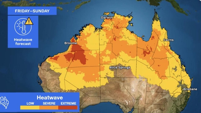
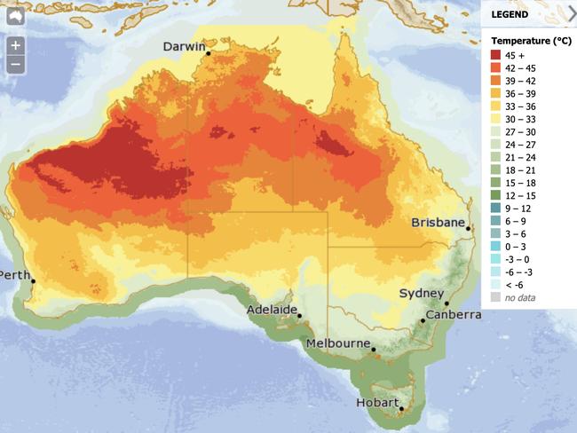
Meanwhile, a massive heatwave has begun to develop across the northern half of Australia, with most of Queensland, the NT and WA impacted by low-intensity conditions.
Pockets of severe heat are forecast in central areas of all three jurisdictions between Friday and Sunday, as well as extreme heatwave conditions around Broome and Darwin.
The heat doesn’t, however, mean dry weather. Many of the same areas will be impacted by the rain event, making for a hot and humid New Year’s Eve.
The rain event doesn’t end on New Year’s Eve, either. In fact, the forecast indicates a wet start to 2024 across large parts of Australia, as a second area of low pressure builds from next week.
“Heading into the first few days of the new year, we see the risk of severe thunderstorms continue across much of eastern Australia, even extending down into NSW and Victoria by the middle of [next] week,” Mr How explained.
State-by-state New Year’s Eve forecast
Though many areas are likely to be rainy, with a bit of luck, most of the capitals should dry out by the time midnight rings in.
NSW
Northeastern NSW is expected to shoulder a significant portion of Sunday’s stormy weather, though rain is expected in varying amounts across the entire NSW coast and into the central west.
Showers and cool conditions are expected in Sydney on New Year’s Eve, but the rain is forecast to clear up in time for the midnight fireworks. The famous display may, however, be obscured by lingering cloud cover.
A low of 18C is forecast in Sydney on Sunday, warming up to 24C.
Victoria
Victoria, too, is forecast experience a wet weekend, though not as drastically as NSW and Queensland.
The rain is forecast to focus on the state’s north, with showery conditions in the south.
Though rain is expected in Melbourne on Saturday, it should clear by New Year’s Eve on Sunday, when partly cloudy conditions and a high of 21C are forecast.
Queensland
Queensland is expected to be the state worst affected by the rain event, with large parts of its east coast forecast to receive totals exceeding 50mm.
Isolated severe storms in Bundaberg and Gympie could drive those totals past 200mm between Friday and Monday.
Brisbane is set to be the wettest capital city on New Year’s Eve. Showers and potential thunderstorms are forecast to ring in 2024 and are unlikely to clear before the evening fireworks show.
A low of 22C, warming up to 29C, is expected.
WA
In WA, the rain is forecast to be isolated to the state’s southern and northern coasts, with a fairly dry interior.
Severe heatwave conditions are building around Broome and the northwest.
Farther south in Perth, it should be a sunny end to 2023, with blue skies and a high of 31C forecast on Sunday.
SA
SA is expected to stay mostly dry through the weekend, save slight showers in the southeast and southwest.
The state’s interior may be impacted by severe heatwave conditions around the red centre.
New Year’s Eve should be sunny in Adelaide, with a maximum temperature of 26C.
Tasmania
Light rain is forecast in Tasmania through the weekend, particularly in the western half of the state.
Hobart should largely escape the wet weather, with a high of 23C forecast on Sunday.
NT
The NT is forecast to stay largely dry this weekend, save rainfall on the northern coast driven by the wet season.
Darwin’s New Year’s Eve weather is characteristic of this time of year, with rain and a possible thunderstorm forecast on Sunday, as well as a high of 35C.
Originally published as Australians brace for stormy New Year’s Eve washout

Severe frost alert for Aussie farmers
Farmers are being urged to keep their livestock warm as a freezing start to winter puts animals at risk.
Severe frost alert for Aussie farmers
Farmers are being urged to keep their livestock warm as a freezing start to winter puts animals at risk.