
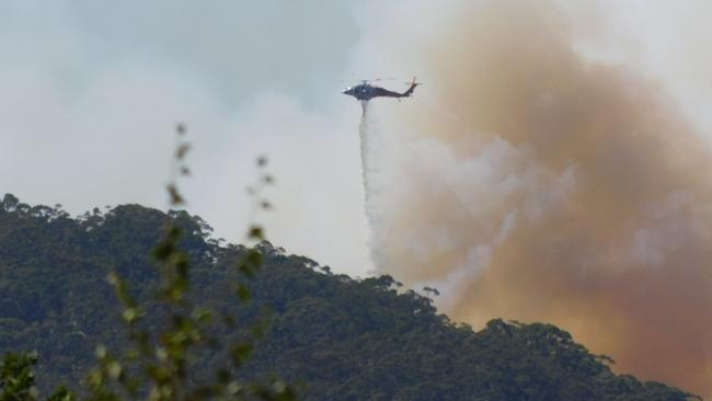
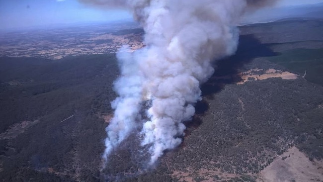
Air support and ground crews fight Mt Buninyong bushfire
A relief centre has been opened for people evacuated due to an out of control bushfire travelling south at Mt Buninyong.
Goulburn Valley
Don't miss out on the headlines from Goulburn Valley. Followed categories will be added to My News.
MT BUNINYONG UPDATE, 3.56PM MARCH 5: A bushfire at Mt Buninyong is not yet under control with a relief centre now open at the Buninyong Community Facilities and Reserve.
The bushfire is travelling in a southerly direction towards Scotsburn.
A watch and act has been issued for residents in Buninyong and Scotsburn to monitor conditions and enact fire survival plans.
People are encouraged to leave if they feel unsafe and are reminded to take pets, medications, phones and phone charges.
Mt Buninyong Rd from Yendon No 1 Rd to the top of Mt Buninyong, Yendon No 2 Rd between Yuulong Rd and the Midland Highway, Yuulong Rd between Yendon No 2 Rd and the Midland Highway, and Blackberry Lane between Mt Buninyong Rd and Granny White Lane are closed.
Advice to stay informed has been issued for areas of Buninyong and Scotsburn to the north and east of Mt Buninyong.
There is currently no threat to that community but should be prepared if the situation changes.
The fire began before noon on Wednesday and at least 17 emergency services vehicles are responding.
Air attack support has also been called in for the incident.
People can stay informed using the VicEmergency app, website or hotline.
GLENROWAN UPDATE, TUESDAY:
More than 30 firefighting units are battling a grassfire near Glenrowan with air attack crews called in for support.
A Country Fire Authority (CFA) spokesman said units responded to reports of a grassfire on Glenrowan-Moyhu Rd about 2pm on Monday.
“32 CFA appliances from multiple local brigades responded to the incident,” he said.
“Upon arrival, crews found an active grass and scrub fire travelling in a north-easterly direction.
“Air attack support was requested to assist ground crews.”
The spokesman said a watch and act warning to monitor conditions as they are changing remained current for Glenrowan, Greta West, Laceby.
Increased wind speed, change in wind direction, smoke or poor visibility can indicate the situation is changing.
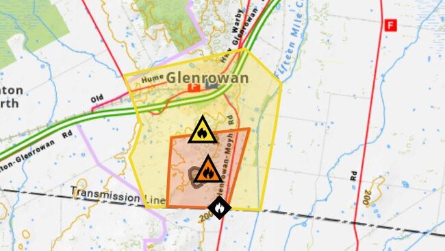
The spokesman said Glenrowan-Moyhu Road between Laceby-Glenrowan Road and Mills Road in Glenrowan were closed.
“The fire has burnt approximately 24ha,” he said on Tuesday afternoon.
“The incident is not yet under control.”
People are also encouraged to enact their fire survival plan.
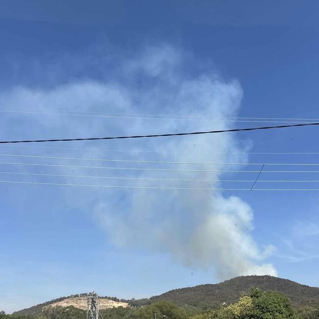
Smoke will visible from nearby communities and roads and people are asked to be aware of emergency services moving in the area.
Firefighters have been able to slow the spread of fire for now, but the situation could change at any time.
People can stay informed using the VicEmergency app, website or hotline.
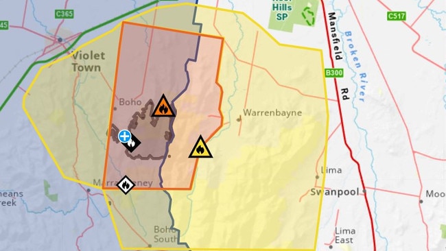
It comes as a fire in the in the Strathbogie State Forest near Violet Town has now burnt more than 1400ha as firefighters continue to work to keep the blaze contained.
At noon on Tuesday there were at least 38 emergency service vehicles responding to the scene.
The fire is now under control.
The previous “watch and act” message has been changed to an advice message to stay informed for Baddaginnie, Boho, Boho South, Marraweeney and Warrenbayne.
Communities are advised there was currently no threat, but they should stay informed and plan for what they would do if the situation changes.
Smoke will remain visible from the Hume Freeway and surrounding towns including Benalla, Euroa and Violet Town
Firefighters are focusing on treating unburnt areas within the constructed containment lines while aircraft and heavy machinery will remain in the area.
There are road closures in place at intersections of Boho Church Rd and Smiths Rd, Creamery Rd and Hayes Rd, Boho Rd and School Rd, Upper Boho Rd and Mildrens Track and Sessions Rd and Mildrens Track.
STRATHBOGIE UPDATE, MONDAY:
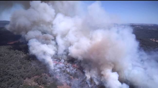
More than 180 firefighters are battling a bushfire at Boho Stilo’s Track in the Strathbogie State Forest near Violet Town.
The fire was first reported on March 1 and had spread to 1220ha by Monday morning, travelling in a northerly direction.
It is not yet under control.
Forest Fire Management Victoria (FFMVic) incident controller Scott Edwards said the firefighting focus was to directly attack the fire and hot spots with aircraft and crews.
“Machinery is working around the clock to construct containment lines as close to the fire as it is safe to do so.
“Backburning operations are helping to strengthen the containment lines to protect private property and adjoining pine plantations.”
There is a “Watch and Act Bushfire – Threat is Reduced – Monitor Conditions” message in place for Baddaginnie, Boho, Boho South, Warrenbayne.
Residents have been advised the spread of the bushfire had “slowed for now”, but the situation could change at any time.
Increased wind speed, change in wind direction, smoke or poor visibility can indicate the situation is changing.
People are encouraged to enact their fire survival plan and leave if they feel unsafe.
An Advice Bushfire Stay Informed message is also current for surrounding communities including Harry’s Creek, Lima, Marraweeney, and Violet Town.
For those communities there is no current risk but residents are asked to monitor conditions, review fire plans and keep roads clear for emergency services.
Community information meetings were held yesterday at Boho and Warrenbayne.
FFMVic firefighters are being supported by Country Fire Authority units.
On-ground crews are being supported by firebombing aircraft and 17 dozers, graders and excavators which are working around the clock to construct containment lines around the 17km perimeter of the fire.
The cause of the fire is currently under investigation by police.
A Victoria Police spokesman said the cause of the fire was yet to be determined and a fire investigator would attend the scene.
“The investigation is ongoing and anyone with information should contact Crime Stoppers on 1800 333 000 or visit www.crimestoppersvic.com.au,” he said.
Upper Boho and Desaillys Rd, Upper Boho Road and Boho Church Rd, Sessions Rd and Hurrell Rd is closed.
Smoke may be visible from the Hume Freeway and surrounding towns including Benalla, Euroa and Violet Town.
People can stay informed using the VicEmergency app, website or hotline.


How Shepparton could join ‘Big Things’ list
Are you really an Australian town if you don’t have a Big Thing? For Shepparton that answer could come in the shape of a Big Pear. Find out how.

Cobram house fire sends court matter into disarray
A committal for the alleged killer of a Cobram woman has been thrown into disarray after a witness was charged with setting a house on fire at the weekend.