
Picture special: How Victoria’s beach destinations have changed over a decade
Shocking images show how the state’s most visited beach destinations have changed due to wild winds, damaging tides and rising sea levels.
Bass Coast News
Don't miss out on the headlines from Bass Coast News. Followed categories will be added to My News.
Erosion has been seen on coastlines around the world for hundreds of years.
Each winter, beaches around Victoria endure wild winds, damaging tides and rising sea levels before they regenerate in the summer.
But this year La Nina exposed some beaches to unforeseen weather conditions which compounded the conditions ahead of winter.
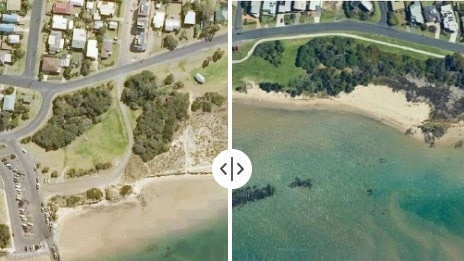
Visible impacts of erosion include loss of dune vegetation, receding sand or falling cliff faces, while other impacts such as exposed reefs are best seen from above.
See the shocking aerial images provided by Nearmap and the Bass Coast Shire Council of the changing face of Victorian beaches from the past decade.
The Great Ocean Road is a world-famous destination on the southern coast of Victoria, and covers more than 240km from Warrnambool to Torquay.
But recent events threaten the destination as the ocean encroaches on infrastructure, vegetation and natural wonders.
The Great Ocean Road Coast and Parks Authority reported a 5m swell combined with the highest astronomical tide on May 18.
It was the “perfect storm” that damaged a rock wall at Cosy Corner and caused sand lost at Point Impossible Beach.
Beaches were also affected at Lorne, Kennett River, Jan Juc and Wye River.
Wye River is a “priority” for the authority as recent events led to urgent protective measures.
In 2019 the river channel migrated to the east and threatened to encroach on the Surf Life Saving Club and the camping grounds.
This shift significantly increased the erosion of the dune as the combination of the river flow and wave action battered the sand.
According to the authority, 15m of dune has been lost in two years.
Groynes were installed in 2021 which successfully shifted the river channel west, away from the infrastructure, and sand began to regenerate on the beach.
To further protect Wye River, sand renourishment works are underway to shield the foreshore ahead of winter — typically the season which experiences increased river flows and wave action.
This, however, is a short-term solution as the authority suggests installing groynes could shift the problem further south.
Jan Juc has experienced erosion over the past decade, as seen in the images.
The reef is now exposed and the beach is classified with a high erosion rating thanks to data collected by the authority as part of the Victorian Coastal Monitoring Program.
The coastline is more prominent as the ocean carves out the cliff each winter.
In September 2021, the Department of Environment, Land, Water and Planning, Parks Victoria and the Great Ocean Road Coast and Parks Authority determined the temporary beach closure at Demons Bluff, Anglesea would be made permanent.
The decision was made as landslides and cliff cracks were declared unsafe to the public.
Tensions cracks of up to 50m long and 2m deep are seen in the area which means cliff falls are inevitable.
Fencing, permanent signage and exclusion zones will be reinforced to ensure the safety of everyone who visits this section of beach.
Groyne work is underway in Apollo Bay to help preserve the beach and manage coastal erosion.
The $7.4m two-stage project began in February last year with stage one already complete.
Upon completion, three 70m groynes will be installed, as well as two rock seawalls which will protect the dune, walking path, cypress trees and Great Ocean Road.
Bells Beach is Australia’s most famous wave break which hosts the Rip Curl Pro each year, but the cliffs are eroding and becoming unstable.
In the past decade, Inverloch Beach has lost 70m of sand.
Simon Woodland, Bass Coast council’s environmental scientist said the impacts of coastal erosion are devastating the community.
“Over recent years, people have literally watched the ocean advance and dunes collapse in front of them, and they feel helpless,” he said.
Other areas affected by erosion on the Bass Coast include Kilcunda, when a section of the Bass Coast Rail Trail was relocated in 2021, and Phillip Island’s main town, Cowes.
The construction of rock walls and groynes are underway to ensure the longevity of the beach, but Bass Coast’s mayor Michael Whelan said they were short-term solutions.
“As the energy of the sea crashes in to the rock walls, we end up losing the beach in front of them. They also require maintenance, they’re not the answer,” he said.
Permanent solutions for coastal erosion depend largely on monitoring and analysis based responses which takes time and costs money.
Councils along the coastline are asking for funding to assist in protecting the famous destinations in order to maintain Australia’s identity as a world-class beach destination.
The imagery is from Australian location intelligence Nearmap- a company which provide high resolution aerial imagery, city-scale 3D content, artificial intelligence data sets, and geospatial tools to businesses.
This assists with urban planning, monitoring and development projects in Australia, New Zealand, and North America.


Bass Coast sale and auction results, week ending June 21
See the latest auction and sales results on the Bass Coast for last week.

Group of teens break windows, yell at children in Yarragon
A group of teens have stirred up trouble in a small Gippsland town by smashing the windows of the local primary school, climbing on football club equipment and yelling at children.